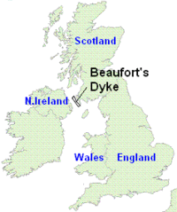
Beaufort's Dyke
Coordinates: 54°47′06″N 5°25′12″W / 54.785°N 5.420°W
Beaufort's Dyke is the sea trench between Northern Ireland and Scotland within the North Channel. The dyke is 50 km long, 3.5 km wide and 200–300 metres deep.

Because of its depth and its proximity to the Cairnryan military port, it became the United Kingdom's largest offshore dump site for conventional and chemical munitions after the Second World War; in July 1945, 14,500 tons of 5-inch artillery rockets filled with phosgene were dumped in Beaufort's Dyke.[1] The Ministry of Defence estimates that there is well over a million tons of munitions at the bottom of Beaufort's Dyke [2]
Munitions have subsequently been washed up on beaches in the area. In particular, in 1995, incendiary devices were discovered on the Scottish and Northern Irish coasts. This coincided with the laying of the Scotland-Northern Ireland pipeline (SNIP), a 24-inch gas interconnector being constructed by British Gas.
Projects for a tunnel or Irish Sea fixed crossing between Northern Ireland and Scotland have been suggested at various times from the late nineteenth-century onwards. The Dyke has always been an important problem for such proposals, in terms both of practicality and cost.
Nuclear waste
According to documents discovered at the Public Record Office approximately two tonnes of concrete-encased metal drums, filled with radioactive laboratory rubbish and luminous paint, were dumped into Beaufort Dyke, 300 metres deep and 10 kilometres off the Scottish coast.[3]
References
- ↑ Dr. Lewis Moonie, Member for Kirkcaldy (23 April 2002). "Beaufort Trench (Mustard Gas)". Parliamentary Debates (Hansard). House of Commons. col. 192W–193W.
- ↑ http://news.bbc.co.uk/1/hi/sci/tech/4032629.stm
- ↑ Arthur, Charles (1 July 1997). "Ministers admit nuclear waste was dumped in sea". The Independent. London: INM. Retrieved 29 April 2015.
External links
Bibliography
- G FORD, L OTTEMÖLLER, B BAPTIE. 2005. Analysis of Explosions in the BGS Seismic Database in the Area of Beaufort’s Dyke, 1992-2004. British Geological Survey Commissioned Report, CR/05/064. 15pp.