Becca di Nona
| Becca di Nona Pic de Nona | |
|---|---|
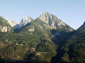 Becca di Nona in the foreground, with the higher Monte Emilius in the background (left). | |
| Highest point | |
| Elevation | 3,142 m (10,308 ft) |
| Coordinates | 45°41′17.19″N 7°21′54.09″E / 45.6881083°N 7.3650250°ECoordinates: 45°41′17.19″N 7°21′54.09″E / 45.6881083°N 7.3650250°E |
| Geography | |
 Becca di Nona Pic de Nona Location in Italy | |
| Location | Aosta Valley, Italy |
| Parent range | Graian Alps |
Becca di Nona (French: Pic de Nona) is a peak in the Graian Alps of the Aosta Valley in north-western Italy. Together with Monte Emilius, it is one of the main mountains visible from Aosta looking southwards.
History
This mountain was known in the past as Pic de douze heures, that is to say "12 p.m. peak" in French, as the sun stands right on top of it at noon.
In 1857, the Aostan mountaineer and doctor Laurent Cerise nominated it Pic Carrel, to dedicate it to Georges Carrel, but his proposal was not accepted.
The hagiography of St Anselm written by his chaplain Eadmer records that, when he was a child, he had a mystical vision of God and his court on the mountain.[1]
Sports
At the top is a cast iron statue of St. Mary. Every year a running race, the Becca di Nona Skyrace or Skyrace Ville d'Aoste, is organized starting from Émile Chanoux square in Aosta, arriving to the peak and returning to the city.
References
Citations
- ↑ Rule (1883), p. 12–14.
Bibliography
- Rule, Martin (1883), The Life and Times of St. Anselm, Archbishop of Canterbury and Primate of the Britons, Vol. I, London: Kegan Paul, Trench, & Co.