Beinn Eighe
| Beinn Eighe - Ruadh-stac Mòr | |
|---|---|
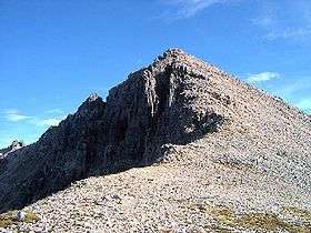 Sgurr nan Fhir Duibhe, one of the peaks of Beinn Eighe | |
| Highest point | |
| Elevation | 1,010 m (3,310 ft) [1] |
| Prominence | 632 m (2,073 ft) [2] |
| Parent peak | Liathach |
| Listing | Munro, Marilyn |
| Naming | |
| Translation | Big Red Stack (Gaelic) |
| Pronunciation | Scottish Gaelic: [peɲ ˈe.ə ˈrˠuəs̪t̪ak ˈmoːɾ] |
| Geography | |
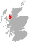
| Location | Torridon Hills, Scotland |
| OS grid | NG951611 |
| Topo map | OS Landranger 19 |
| Listed summits of Beinn Eighe | ||||
| Name | Grid ref | Height | Status | |
|---|---|---|---|---|
| Ruadh-stac Mòr | NG951611 | 1,010 m (3,314 ft) | Marilyn, Munro | |
| Spidean Coire nan Clach | NG966597 | 993 m (3,258 ft) | Munro, Marilyn | |
| Sail Mhòr | NG938605 | 980 m (3,215 ft) | Munro Top, Murdo | |
| Còinneach Mhòr | NG944600 | 976 m (3,202 ft) | Munro Top, Murdo | |
| Sgùrr Bàn | NG974600 | 970 m (3,182 ft) | Munro Top, Murdo | |
| Sgùrr nan Fhir Duibhe | NG981600 | 963 m (3,159 ft) | Munro Top, Murdo | |
| Creag Dhubh | NG983604 | 930 m (3,051 ft) | SubMurdo | |
| Creag Dhubh North Top | NG985607 | 909 m (2,982 ft) | deleted Munro Top | |
| Ruadh-stac Beag | NG972613 | 896 m (2,940 ft) | Corbett, Marilyn | |
Beinn Eighe is a complex mountain massif in the Torridon area of the Highlands of Scotland. It forms a long ridge with many spurs and summits, two of which are classified as Munros. The name Beinn Eighe comes from the Scottish Gaelic meaning File Mountain. Unlike the neighbouring hill Slioch it has a cap of Cambrian basal quartzite which gives the peaks of Beinn Eighe a distinctive light colour. Its complex topography has made it popular with both hillwalkers and climbers and the National Nature Reserve on its northern side makes it an accessible mountain for all visitors.
Geography
Located between Loch Maree and Glen Torridon on the west coast of Scotland, Beinn Eighe is a complex mountain. A main ridge runs on a line extending from close to Kinlochewe in the north-east to the narrow glen of the Coire Dubh Mor separating it from the neighbouring mountain of Liathach in the south-west. The slopes into Glen Torridon on the south side are steep with few features and covered in white quartzite screes. On the north side are four large corries between which are a series of spurs extending out from the main ridge.[3]
Munro Summits
Two of Beinn Eighe's summits are classified as Munros. Ruadh-stac Mòr ('Big Red Stack' in Scottish Gaelic) is on one of the spurs off the main ridge and stands at a height of 1,010 m (3,314 ft). The second Munro, Spidean Coire nan Clach ('Peak of the Corrie of Stones' in Scottish Gaelic), is the highest point on the main ridge itself. It stands at a height of 993 m (3,258 ft) and commands an extensive view over both Glen Torridon and the rest of the Beinn Eighe massif.
Triple Buttress
One of the most famous features of Beinn Eighe is the corrie of Coire Mhic Fearchair, often simply known as the “Triple Buttress Corrie” after the three large rock features which dominate the view from the north. There are many rock climbs on the buttresses and hillwalkers can access the tops of the buttresses from the head of the corrie.
The Triple Buttress was also the scene of an aviation tragedy. A post-war converted Lancaster, now operating in a maritime reconnaissance role by 120 Squadron, had taken off from RAF Kinloss just after 18.00 hours on the evening of 13 March 1951 for a NAVEX in the vicinity of Rockall and the Faroe Isles. The aircraft was due back at RAF Kinloss around 02.25 hours the following morning. However, while on the return journey, the aircraft experienced atrocious and freezing weather conditions, together with a strong N'Easterly wind. Some time after transmitting its last radio message, the Lancaster crashed just 4.6m (15 feet) below the summit of Beinn Eighe, and at the top of the almost inaccessible Far West Gulley ('Fuselage Gulley'), west of Triple Buttress and above Loch Coire Mhic Fhearchair. Unaware of the crash location, the search teams could still find no trace of the missing aircraft after two days. However, at the time of the accident, a boy in Torridon had witnessed a red glow over Beinn Eighe. Believing this to be coming from one of the fishing boats on the loch, he thought nothing of it. However, two days later, on hearing about the missing aircraft, he remembered what he had seen and reported it. RAF Kinloss were notified of the boy's report together with the reports of several other witnesses who also had seen the red flash over Beinn Eighe. As a result of these reports, the RAF redirected their search efforts to the extensive ridge which included Beinn Eighe. On 16 March, an Airspeed Oxford aircraft located the crashed Lancaster on the mountain and reported its position back to the ground search teams. The rescue teams arrived at the base of the mountain on 17 March and began their attempted recovery from 18 March onward. However, because of the very difficult terrain and atrocious winter weather conditions, the teams could not reach the Lancaster, even after several attempts.
Although experienced civilian mountaineers offered their services, the RAF declined their assistance initially. This was unfortunate, as—unlike today, and unlike the civilian mountaineers of that day—RAF recovery teams were not fully trained or equipped for arduous mountain rescues or recoveries. Indeed, it was as a result of this incident that the modern RAF Mountain Rescue Teams (RAF MRTs) were formed. Eventually, two Royal Marine commandos reached the crash site and located one of the bodies. A few more bodies were recovered by the end of March—two weeks after the accident. However, it was not until nearly 6 months later—on 28 August 1951—that the remaining bodies of the eight crew members were recovered from the site. Local Keepers and Ghillies also assisted using Garrons (horses) to evacuate the bodies from the mountain. This would be the start of the local Kinlochewe and Torridon Mountain Rescue Team.
Those who died in this tragic accident were:
•Fl/Lt Harry Smith Reid DFC (29), Pilot, RAF.RAF.Buried Groves Cemetery Aberdeen
•Sgt Ralph Clucas (23), Co-Pilot, RAF. Buried at Kinloss Abbey.
•Flt Lt Robert Strong (27), Navigator, RAF. Buried Bramwood End Cemetery, Birmingham
•Fl/Lt Peter Tennison (26), Air Signals, RAF. Buried at Kinloss Abbey.
•Sgt James Naismith (28), Air Signals, RAF. Buried at Kinloss Abbey.
•Sgt Wilfred D Beck (19), Air Signals, RAF. Buried at Kinloss Abbey.
•Sgt James W Bell (25), Air Signals, RAF. Buried at Kinloss Abbey.
•Sgt George Farquhar (29), Flight Engineer, RAF.RAF. Buried Buckie Cemetery, Banffshire.
Geology
Beinn Eighe is unusual amongst the Torridon mountains in that its summit is not composed of Precambrian Torridonian Sandstone, but Cambrian basal quartzite, a very hard but brittle rock. This gives it its familiar light coloured summits, a notable contrast to the other peaks in the area. Underlying the quartzite is a bed of Torridonian Sandstone.
Ascents
Beinn Eighe's complex topography offers both hillwalkers and climbers a wide variety of routes, climbs and traverses. For the hillwalker a popular route is the western traverse which includes both of the Munro summits and Coire Mhic Fearchair. A full traverse of Beinn Eighe includes navigating a series of pinnacles known as the Black Carls, which provide good scrambling and are located at the eastern end of the main ridge. Approached from the National Nature Reserve the Black Carls are a popular climb in their own right. Also within the National Nature Reserve, a moderate route ascends to the 'Conservation Cairn' at 560 m (1,837 ft) which offers extensive views of the surrounding landscape including Loch Maree and the nearby mountain Slioch.
National Nature Reserve
The Beinn Eighe National Nature Reserve is managed by Scottish Natural Heritage. Declared in 1951 by Dr John Berry in his role as Director of Nature Conservancy in Scotland,[4] it was the first such area in Great Britain.[5] Scottish Natural Heritage provides a visitor centre two miles north-west of Kinlochewe, extensive marked trails through woodland on the lower slopes of Beinn Eighe, picnic areas and viewpoints. SNH also provides a field station with full laboratory facilities for up to fourteen people.[6] which is used by scientists and researchers to co-ordinate field data recording and as a base for undergraduate fieldwork.
Within its 4,800 hectares, the reserve includes open moorland, woodland and bogs, and is home to protected species including red deer, golden eagles and pine martens. Many rare plants, including two variants of dwarf shrub heath and a western variant of moss heath, are also to be found on the reserve.
Beinn Eighe is also a UNESCO Biosphere reserve.
Gallery
-
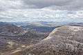
View from the top of Ruadh-stac Mòr to the north east
-
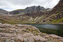
The triple buttresses of Coire Mhic Fearchair
References
- ↑ Butterfield, Irvine; David & Charles (2000). The Magic Of The Munros (2nd ed.). Hong Kong Graphics & Printing Ltd:. ISBN 0-7153-0850-5.
- ↑ "Beinn Eighe - Ruadh-stac Mor, Scotland". Peakbagger.com. Retrieved 2009-08-21.
- ↑ "Walking Scotland - Beinn Eighe". Retrieved 2009-08-21.
- ↑ http://www.royalsoced.org.uk/cms/files/fellows/obits_alpha/berry_john.pdf
- ↑ "Beinn Eighe National Nature Reserve Website". Retrieved 2009-08-21.
- ↑ "UNESCO Beinn Eighe Biosphere Reserve Information Website". Retrieved 2009-08-21.
6. http://www.aircrashsites-scotland.co.uk/lancaster_eighe.htm
External links
| Wikimedia Commons has media related to Beinn Eighe. |
 |
|  | |
| Northern Highlands | 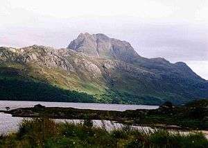  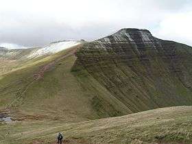 | |
|---|---|---|
| Western Highlands | ||
| Central and Eastern Highlands | ||
| Southern Highlands | ||
| Islands | ||
| Scottish Lowlands, England and Wales | ||