Belcarra Regional Park
| Belcarra Regional Park | |
|---|---|
|
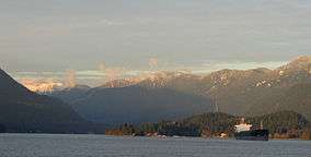
Belcarra Regional Park from Westridge Terminal. Eagle Ridge in the background, with part of Mamquam Mountain, which lies east of Squamish, visible at left rear. | |
 | |
| Location | British Columbia, Canada |
| Nearest city | Belcarra, British Columbia |
| Coordinates | 49°19′06″N 122°53′37″W / 49.3184°N 122.8936°WCoordinates: 49°19′06″N 122°53′37″W / 49.3184°N 122.8936°W |
| Area | 1,100 hectares (2,700 acres) |
| Governing body | Metro Vancouver |
| http://www.metrovancouver.org/services/parks/parks-greenways-reserves/belcarra-regional-park | |
Belcarra Regional Park is a 1,100-hectare (2,700-acre) regional park located in metropolitan Vancouver, British Columbia.[1] It is northeast of the meeting of Burrard Inlet with Indian Arm, beginning near Belcarra Bay and extending to Sasamat Lake. Sasamat is one of the warmest lakes in Greater Vancouver. It's located in Belcarra Regional Park. The park is northwest of the Village of Anmore and to the southwest of Buntzen Lake.
Included in the park is a First Nations archaeological site, which is operated and maintained by Metro Vancouver Regional Parks.[2]
References
- ↑ Belcarra Regional Park Metro Vancouver
- ↑ Sydney Charlton (1977). "The archaeology of the Belcarra Park site : a contribution to Strait of Georgia prehistory".
This article is issued from Wikipedia - version of the 11/18/2016. The text is available under the Creative Commons Attribution/Share Alike but additional terms may apply for the media files.