Berat County
| Berat County Qarku Berat | ||
|---|---|---|
| County | ||
|
| ||
| ||
 Location of Berat County within Albania. | ||
| Coordinates: 40°38′N 20°5′E / 40.633°N 20.083°ECoordinates: 40°38′N 20°5′E / 40.633°N 20.083°E | ||
| Country |
| |
| Municipalities | 5 | |
| Villages | 239 | |
| Established | 2000 | |
| County Seat | Berat | |
| Government | ||
| • Council Chairman | Fatlli Adilaj | |
| Area | ||
| • Total | 1,798 km2 (694 sq mi) | |
| Elevation | 455 m (1,493 ft) | |
| Population (2015 census) | ||
| • Total | 135,944 | |
| • Density | 76/km2 (200/sq mi) | |
| Time zone | CET (UTC+1) | |
| • Summer (DST) | CEST (UTC+2) | |
| NUTS Code | AL031 | |
| Website | Official Website | |
Berat County (Albanian: Qarku i Beratit) is one of the 12 counties of Albania. The population at the 2011 census was 141,944, in an area of 1798 km².[1] Its capital is the city Berat.
History
Archaeologists have found artifacts including silver women's earrings and bronze belt-buckles in Bronze Age tumuli in Pëllumbas, one of the villages of Berat. These items are similar to other artifacts found in northern Albania (Kukës and Mat), Kosovo (Gjilane) and northwestern Greece (Pogoni).[2]
Antipatrea (Greek: Αντιπάτρεια) was an ancient Greek polis in the region of Epirus, now Berat. It was founded by Cassander as Antipatreia, who named it after his father Antipater at 314 BC.[3] An ancient Greek fortress and settlement are still visible today.[4] Dassaretae tribe existed in the area,[5] as early as the 6th century BC. It was captured by the Romans in the 2nd century BC. Livy (31.27.2) describes Antipatrea as a strongly fortified city in a narrow pass that the Romans sacked and burned. The city was composed of two fortifications on both banks of the Osum River.[6]
Historical manuscripts such as the 6th century Codex Purpureus Beratinus, discovered in 1868,[7] and the Codex Aureus, a 9th-century Greek language manuscript have revealed much about the history of the region and that Berat had a reputation for producing manuscripts; 76 of the 100 codes protected in the National Archives of Albania are from Berat, indicating its historical importance.[6][8]
The town of Berat became part of the unstable frontier of the Byzantine Empire following the fall of the Roman Empire and, along with much of the rest of the Balkan peninsula, it suffered from repeated invasions by Slavs and other tribes. During the Byzantine period, it was known as Pulcheriopolis.[6]
The Bulgarians under Simeon I captured the town in the 9th century and renamed it Beligrad (White City). They were eventually driven out in the 11th century. During the 13th century, it fell to Michael I Ducas, the ruler of the Despotate of Epirus.[6]

In the latter part of the 13th century Berat again came under the control of the Byzantine Empire. In 1272 Berat was captured by the forces of the Kingdom of Albania, while Michael VIII Palaiologos sent letters to the Albanian leaders of Berat and Durrës asking them to abandon their alliance with Charles I of Naples; they sent the letters to Charles as a sign of their loyalty.[9]
In 1274 Michael VIII recaptured Berat and after being joined by Albanians, who supported the Byzantine Empire marched unsuccessfully against the Angevin capital of Durrës.[10]
In 1280–1281, the Sicilian forces under Hugh the Red of Sully laid siege to Berat. In March 1281, a relief force from Constantinople under the command of Michael Tarchaneiotes was able to drive off the besieging Sicilian army.[11] In 1335-1337, Albanian tribes took control of the area between Berat and Vlorë for the first time, that time the Muzakaj formed the Lordship of Berat.[12][13] Serbs took control of the area in 1345.[6] Later, it passed back into the hands of Muzakaj, restoring the Lordship, until 1450.
The Ottoman Empire conquered it in 1450 from the Muzakaj family. Skanderbeg's Albanian forces unsuccessfully besieged the fort in 1455. It remained under Ottoman control until 1912, when it became part of Albania. Ali Pasha (born 1744-died 1822), an Ottoman Albanian ruler, took control of Berat between 1788-1822, as a semi-autonomous ruler. His domains were called the Pashalik of Yanina. He refortified the city in 1809.[6][14] In 1867, Berat became a sanjak in the Janina (Yanya) vilayet. During Ottoman rule, it was known Arnavut Belgradı in Turkish (meaning "Albanian Belgrade") at first and then Berat.
During the early period of Ottoman rule, Berat fell into severe decline. By the end of the 16th century, it had only 710 houses. However, it began to recover by the 17th century and became a major craft centre in the Ottoman Balkans, specializing in wood carving. During the 19th century, Berat played an important part in the Albanian national revival.[6] It became a major base of support for the League of Prizren, the late 19th century organisation which was pro-Albanian independence.
Between 1912 and 1914, it was under the control of the Albanian provisional government, and controlled by the Principality of Albania between 1914 and 1915. It was occupied by the Allies in 1915 during the First World War, despite Albania's neutrality, before falling to Austro-Hungarian forces in 1916. Austria-Hungary sustained the occupation until 1918, after which it was occupied by Italy. Italy had plans to create an autonomous province over Albania, including the area of Berat. However, following the defeat of Italy in the Vlora War, Albania retook control of Berat. Italy again occupied Berat in 1939 during the Italian invasion of Albania. Following Italy's capitulation, Germany occupied Albania between 1943 and 1944. In November 1944, the communist-controlled Anti-Fascist National Liberation Council of Albania declared in Berat that it was the provisional government of the country, signalling the beginning of the Enver Hoxha dictatorship.[6] Communist Albania retained control over Albania for many decades, until finally falling in 1992. Berat has since then been part of the Republic of Albania.
Geography
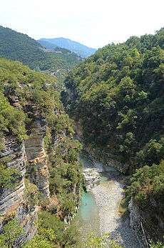
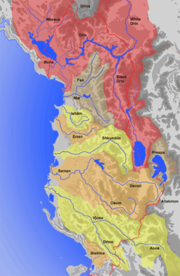
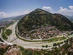
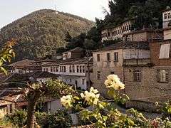
Alone among the counties of Albania, Berat neither borders the sea nor another country. It is bounded by Elbasan County to the north, Korçë County to the east, Gjirokastër County to the south and Fier County to the west. The biggest river is the Osum which flows through the town of Berat and joins the Molisht River. Berat is bounded by Tomorr (known as "Mount Olympus" or "the throne of gods"),[15] elevation 2,416 metres (7,927 ft), and Shpirag, elevation 1,218 metres (3,996 ft), mountains covered with rich pine forests. A deep ravine cut by the Osum River on its west side, which is 915 metres (3,002 ft) deep in a limestone formation, is where the Berat city is situated on stepped terraces. Other rivers include the Çorovoda River which passes through the town of Çorovodë home to the canyon known as "Pirogosh".[6][16]
.jpg)
The geographical formations of the region are frequently mentioned in local folklore. According to legend, Tomorr Mountain personified a giant who fought his brother Shpirag, personified by a nearby mountain, for the love of a young woman.[8] The two brothers fought bitterly for her affections and ended up killing each other. Deep in sorrow, the legend states, the grieving woman for whom they had contested wept over their deaths; her tears created the Osum River.[6][8][17] She was then said to have turned to stone, becoming the foundation on which Berat Castle is now built.[8] Both Tomorr and Shpirag mountains are visible from Berat.
The climate in the region is generally Mediterranean but varies by local topography. There are diverse microclimates in the county, including Alpine.[16] Summers are dry while heavy rains are experienced during the winter. Climate conditions near Berat are conducive to farming and related agricultural industries.[16]
Administrative divisions
Until 2000, Berat County was subdivided into three districts: Berat, Kuçovë, and Skrapar. Since the 2015 local government reform, the county consists of the following 5 municipalities: Berat, Kuçovë, Poliçan, Skrapar and Ura Vajgurore.[18] Before 2015, it consisted of the following 25 municipalities:
The municipalities consist of about 240 towns and villages in total. See Villages of Berat County for a structured list.
Demographics
According to the last national census from 2011 this county has 141,944 inhabitants. Ethnic groups in the county include:[1]
- Albanians = 119,159 (83.95%)
- Greeks = 180 (0.13%)
- Macedonians = 13 (0.01%)
- Montenegrins = 1 (0.00%)
- Aromanians = 670 (0.47%)
- Romani = 202 (0.14%)
- Egyptians = 108 (0.08%)
- others = 36 (0.03%)
- no answer = 20,427 (14.39%)
Religion and culture

The main religions practiced in Berat County are Islam and Orthodox Christianity. The landscape of a mixture of minarets of mosques and grand Orthodox churches and chapels are a testament to the religious coexistence of Berat inhabitants.[19] Berat was the seat of a Greek Orthodox Bishpric in medieval and modern times, and today Aromanian and even Greek speakers can be found in the city and some surrounding villages.[20] In 2008, Berat was added to UNESCO's World Heritage list as an example of the co-existence of religions and cultures.[21]
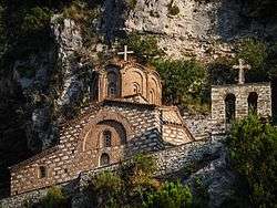
The St. Mary of Blachernae Church in Berat dates to the 13th century and contains 16th century mural paintings by Nikola, son of the Albania's most famous medieval painter, Onufri. The first inscription recording Onufri's name was found in 1951, in the Shelqan church. The Kastoria church dates to 23 July 1547 and has a reference to Onufri's origin: "I am Onufri, and come from the town of Berat." Onufri's style in painting was inherited by his son, Nikola (Nicholas), though not so successful as his father. Onufri's museum contains works of Onufri, Nikola and other painters. There is also a number of icons and some fine examples of religious silversmith's work (sacred vessels, icon casings, covers of Gospel books, etc.). Berat Gospels, which date from the 4th century, are copies (the originals are preserved in the National Archives in Tirana). The church itself has a magnificent iconostasis of carved wood, with two very fine icons of Christ and the Virgin Mary. The bishop's throne and pulpit are also of considerable quality.[6][19]
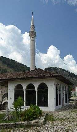
Near the street which descends from the fortress is the Bachelors' Mosque (Albanian: Xhami e Beqareve), built in 1827. It has an attractive portico and an interesting external decoration of flowers, plants, and houses. The King Mosque (Albanian: Xhamia e Mbretit), the oldest in the town built in the reign of Bayazid II (1481–1512), is notable for its fine ceiling. The Lead Mosque (Albanian: Xhamia e Plumbit), built in 1555 and so called from the covering of its cupola. This mosque is the centre of the town. The Halveti Teqe (Albanian: Teqeja e Helvetive) of 1790 is a khanqah (or zawiya) of the Khalwati Sufi order. It has a porch and a carved and gilded ceiling. Near of tekke is purported to be the grave of Shabbatai Zevi, a Turkish Jew who had been banished to Dulcigno (present day Ulcinj) who created controversy among his followers upon his conversion to Islam.[6][19]
Folk music culture exists in Berat County and the performers often wear traditional dress.[6]
See also
References
- 1 2 2011 census results
- ↑ Spieser, J.-M.; Cutler, Anthony; Papaconstantinou, Arietta (2007). The material and the ideal: essays in medieval art and archaeology in honour of Jean-Michel Spieser. BRILL. p. 60. ISBN 978-90-04-16286-0. Retrieved 11 January 2011.
- ↑ Epirus: the geography, the ancient remains, the history and topography of ... by Nicholas Geoffrey Lemprière Hammond, "founded Antipatreia in Illyria at c. 314 BC"
- ↑ The Cambridge Ancient History, Volume 6: The Fourth Century BC by D. M. Lewis (Editor), John Boardman (Editor), Simon Hornblower (Editor), M. Ostwald (Editor), 1994, ISBN 0-521-23348-8, page 423, "These Dassareti not to be confused with the Greek speaking Dexari or Dessaretae of the ," ????
- ↑ The Illyrians by John Wilkes, page 98, "the Dassaretae possessed several towns...Chrysondym, Gertous or Gerous."
- 1 2 3 4 5 6 7 8 9 10 11 12 13 "Berat". Albanian Canadian League Information Service. Archived from the original on 2011-01-10. Retrieved 2010-09-07.
- ↑ Pierre Batiffol, Les manuscrits grecs de Berat d'Albanie et le Codex Purpureus Φ, Paris 1886.
- 1 2 3 4 "The Castle". Castle Park. Archived from the original on December 26, 2010. Retrieved September 5, 2010.
- ↑ Nicol, Donald M. (2010-02-11). The Despotate of Epiros 1267-1479: A Contribution to the History of Greece in the Middle Ages. Cambridge University Press. p. 16. ISBN 978-0-521-13089-9. Retrieved 1 February 2011.
- ↑ Bartusis, Mark C. (1997). The late Byzantine army: arms and society, 1204-1453. University of Pennsylvania Press. p. 62. ISBN 978-0-8122-1620-2. Retrieved 1 February 2011.
- ↑ Norwich, John Julius. The Decline and Fall of the Byzantine Empire. (New York: Alfred A. Knopf, 1996) p. 246-247
- ↑ Steven G. Ellis, Lud'a Klusáková. Imagining frontiers, contesting identities. Edizioni Plus, 2007 ISBN 978-88-8492-466-7, p. 134 "In 1337 the Albanians of Epirus Nova invaded the area of Berat and appeared for the first time in Epirus".
- ↑ Nicholas Geoffrey Lemprière Hammond. Migrations and invasions in Greece and adjacent areas. Noyes Press, 1976, ISBN 978-0-8155-5047-1, p. 61 "By 1335 they were in possession also of the area between Berat and the Gulf of Valona"
- ↑ The New American encyclopaedia: a popular dictionary of general ..., Volume 1. D. Appleton. 1865. p. 354. Retrieved 2010-09-07.
- ↑ "Albanian Tourist Information" (pdf). Republic of Albania. Retrieved 2010-09-07.
- 1 2 3 "Eonomic Development of the City of Berat" (PDF). Agenda Institute. Archived from the original (pdf) on 2010-11-05. Retrieved 2010-09-07.
- ↑ A dictionary of Albanian religion, mythology and folk culture, Robert Elsie, C. Hurst & Co. Publishers, 2001, ISBN 1-85065-570-7, p. 253.
- ↑ Law nr. 115/2014
- 1 2 3 "UNESCO.orgHistoric Centres of Berat and Gjirokastra". Unesco.org. Retrieved 2010-09-07.
- ↑ Winnifrith Tom. Badlands, borderlands: a history of Northern Epirus/Southern Albania. Duckworth, 2002, ISBN 978-0-7156-3201-7, p. 29.
- ↑ Berat as an example of the co-existence of religions and cultures (Albanian)
External links
| Wikimedia Commons has media related to Berat County. |
Counties in Albania are administrative divisions made up of municipalities and local administrative units. | |
| (12) | |
Administrative Divisions of Berat County | ||
|---|---|---|
County Seat: Berat | ||
| Municipality of Berat |  | |
| Municipality of Kuçovë | ||
| Municipality of Poliçan | ||
| Municipality of Skrapar | ||
| Municipality of Ura Vajgurore | ||