Bergenhus
| Bergenhus bydel | ||
|---|---|---|
| Borough | ||
| ||
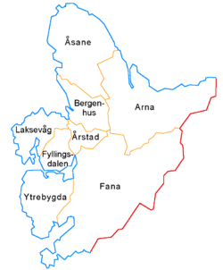 Map of the 8 boroughs of Bergen | ||
| Coordinates: 60°24′N 5°20′E / 60.400°N 5.333°ECoordinates: 60°24′N 5°20′E / 60.400°N 5.333°E | ||
| Country | Norway | |
| Region | Western Norway | |
| County | Hordaland | |
| City | Bergen | |
| Area | ||
| • Total | 25.41 km2 (9.81 sq mi) | |
| Area rank | 6th | |
| 5.7% of total | ||
| Population (2014) | ||
| • Total | 40,606 | |
| • Rank | 2nd | |
| • Density | 1,600/km2 (4,100/sq mi) | |
| 14.9% of total | ||
| Time zone | CET (UTC+01:00) | |
| • Summer (DST) | CEST (UTC+02:00) | |
| ISO 3166 code | NO-120102 | |
Bergenhus is a borough of the city of Bergen in Hordaland county, Norway. This borough encompasses the city centre and is the most urbanized area of the whole city. The 25.41-square-kilometre (6,280-acre) borough has a population (2014) of 40,606. This gives Bergenhus a population density of 1,598 inhabitants per square kilometre (4,140/sq mi).[1]
Location

Named after the historic Bergenhus Fortress, Bergenhus makes up the city centre and the neighborhoods immediately surrounding it, including Sandviken and Kalfaret, as well as the mountains to the north and east of the city centre. It stretches from Haukeland University Hospital in the south to Lønborg in the north, and covers the entire mountain side and the peninsula bounded by the bay of Store Lungegårdsvannet, Puddefjorden and Byfjorden that forms the city's center. Bergenhus is surrounded by the neighborhoods Åsane in the north, Arna in the east, Årstad to the south, Laksevåg to the west and by Askøy to the northwest.
The borough of Bergenhus includes the neighborhoods of Bryggen, Ladegården, Kalfaret, Møhlenpris, Nordnes, Sandviken, Solheimsviken, Sydnes, and Verftet. It is the site of some of the most historic buildings in Bergen including Bergenhus Fortress with Haakon's Hall and Rosenkrantz Tower. It is also the location of the University of Bergen, Bergen Cathedral, Mariakirken, and the Korskirken.
Higher education
Neighborhoods
The list of neighborhoods include: Bontelabo,[2] Bryggen, Eidemarken, Engen, Fjellet, Kalfaret, Ladegården, Marken, Møhlenpris, Nordnes, Nygård, Nøstet, Sandviken, Sentrum, Skansen, Skolten,[2] Skuteviken, Strandsiden, Stølen, Sydnes, Verftet, Vågsbunnen, and Ytre Sandviken.
Sentrum
Sentrum (English: Centre) is a neighborhood (that lies within the boundaries of a former borough with the same name) that borders the neighborhoods Vågsbunnen, Strandsiden, Nøstet, Engen, Sydnes, Nygård and Marken.
The neighborhood lies around Torgallmenningen and Lille Lungegårdsvann.
The boundaries of the neighborhood are the road Østre Muralmenning to the north; Strandgaten, Vågsalmenning, and Allehelgensgate to the east; Fredrik Motzfeldt's Street, Lille Lungerårdsvannet to Fossvinkels gate to St Paul Church, to Rosenbergsgaten, then to Vestre Torvgate, then to Vaskerelven, then down to Vaskerelvsmauet to Olav Vs plass, to Øvre Ole Bulls plass, to Veiten, to Markeveien, to Christian Michelsens gate, to Kalmargaten and Gartnergaten to Kjellersmauet, to Østre Muralmenning.
The neighborhood encompasses three grunnkrets: Strandkaien, Torgalmenningen, and Vaskerelven. These had 818 inhabitants in 2014.
Monuments
Monuments include ["the blue stone"] "Den blå stein"; the one portraying Amalie Skram (located at Klosterhaugen).
Local attractions
| Historical population | ||
|---|---|---|
| Year | Pop. | ±% |
| 1980 | 35,532 | — |
| 1990 | 29,850 | −16.0% |
| 2001 | 32,097 | +7.5% |
| 2011 | 38,544 | +20.1% |
| Source: Statistics Norway. | ||
- Bergenhus Fortress
- Haakon's Hall
- Rosenkrantz Tower
- Koengen
- Sverresborg Fortress (Bergenhus festning)
- St Mary's Church (Mariakirken)
- Bergen Cathedral (Bergen domkirke)
- St John's Church (Johanneskirken)
- Cross Church (Korskirken)
- New Church (Nykirken)
- Sandvik Church (Sandvikskirken)[3]
References
Footnotes
- ↑ Store norske leksikon. "Bergenhus" (in Norwegian). Retrieved 2014-10-22.
- 1 2 Byen i grøften
- ↑ Sandviken (Kirker i Bergen Kommune)
Bibliography
- Hartvedt, Gunnar Hagen (1994). Bergen byleksikon. Oslo: Kunnskapsforlaget. ISBN 8257304859.
- Gjerstad, Jo (2007). En kort beretning om Kalfaret: med hovedvekt på eiendommen Lille Kalfaret: et bidrag til Bergens kulturhistorie. Bergen: Bodonio. ISBN 9788271284664.
- Lidén, Hans-Emil; Magerøy, Ellen Marie (1983). Norges kirker. Oslo. ISBN 8205142998.
Boroughs of Bergen | ||
|---|---|---|
 | ||