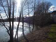
Berges du Rhône
| Quais du Rhône | |
|
Lafayette bridge and Augagneur quay | |
| Length | 5 km[1] (3 mi) |
|---|---|
| Area | 10 ha |
| Coordinates | 45°45′14″N 4°50′17″E / 45.754°N 4.838°ECoordinates: 45°45′14″N 4°50′17″E / 45.754°N 4.838°E |
| Construction | |
| Other | |
| Status | World Heritage Site (1979) |
| Website | Grand Lyon – Berges du Rhône |

The Berges du Rhône (Banks of the Rhône) or Quais du Rhône (Quays of the Rhône) refer to a series of parks, quays, streets and walking paths along the Rhône river in Lyon, France. The construction for the modern Berges du Rhône took place between 2005 and 2007, resulting in the development of 10 hectares of land on the left and right banks of the Rhône from Parc de la Tête d'Or to Parc de Gerland.
History of development
Several dams were built during the nineteenth century to prevent flooding on the left bank of the Rhône, in particular the flood of 1856.[2][3] The Grand Camp dam (digue du Grand Camp) was built in 1859.
Modern development
In 1984, the Lyon Fair was moved from its original location upstream of the quays of the Rhône near Parc de la Tete d'Or to Chassieu to become the Eurexpo. The vacant land was used to build Cité Internationale, which includes the Musée d'art contemporain de Lyon, cinemas, an auditorium, the Palais des congrès de Lyon and the global headquarters of Interpol.
The modern Berges du Rhône
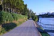
The modern Berges du Rhône were developed with the aim of creating a space for relaxation and leisure activities including paths for walking and cycling along the Rhône. Space was created by eliminating parking spaces. The developed area covers an area of 10 hectares (25 acres), over a distance of 5 kilometres (3.1 miles), from Parc de la Tête d'Or to Parc de Gerland.
In 2001 the Lyon city planning agency developed a scope statement outlining the goals for the project, which included the replacement of parking spaces and flood reduction. The project cost was estimated to be €15.5 million at the time. In 2002 the city released the design for the project.[4]
A development team was chosen in 2003, and a consultation phase began the same year. During the consultation phase, the municipal opposition criticized the removal of parking spaces on the banks of the Rhône and their replacement with paid parking garages. In the second quarter of 2004, the project was presented in its final version. A budget of €44 million was finalized for the project.[5]
In 2005 work began by eliminating parking along the Rhône and constructing a dolphin in the river.[6] Work was completed during the 3rd and 4th quarter of 2007.
Later development
On the right bank Parc Saint-Clair was created, which stretches along the river from the entrance to Saint-Clair to Poincaré bridge.
Construction of the 220-metre (720-foot) long Passerelle de la Paix began in March 2012 and completed in 2013, linking Caluire and Cité internationale.[7]
-
Berges du Rhône at Parc Saint-Clair -
Berges du Rhône at avenue Général-Leclerc
Right bank
The following quays were developed at the right bank of the Rhône:
- Quai Perrache – Perrache
- Quai du Docteur Gailleton – Bellecour
- Quai Jules Courmont – Bellecour
- Quai Jean Moulin – Cordeliers
- Quai André Lassagne – Terreaux
- Cours D'Herbouville – Croix-Rousse
- Cours Aristide Briand – Caluire
- Quai Charles Sénard – Saint-Clair
Left bank

The following quays were developed on the left bank of the Rhône:
- Quai Charles de Gaulle – Brotteaux
- Avenue de Grande-Bretagne – Brotteaux
- Quai de Serbie – Brotteaux
- Quai du général Sarrail – Brotteaux
- Quai Victor-Augagneur – La Part-Dieu
- Quai Claude Bernard – Montplaisir
- Avenue Leclerc – Gerland
- Quai Fillon – Gerland
See also
References
- ↑ "Extraordinary Development Re-connects City With The River Bank". Landscape Architects Network. 30 September 2014. Retrieved 8 January 2016.
- ↑ "Berges du Rhône" (in French). Grand Lyon. Retrieved 5 February 2016.
- ↑ Villien, H. (1937). "L'endiguement du Rhône et de la Saône. les quais de Lyon et leur efficacité contre les inondations" (in French). 13 (1). Retrieved 5 February 2016.
- ↑ Grafton, Quentin; Daniell, Katherine A.; Nauges, Céline; Rinaudo, Jean-Daniel; Wai Wah Chan, Noel, eds. (May 2015). Understanding and Managing Urban Water in Transition. Netherlands: Springer. pp. 532–534. ISBN 9789401798013. Retrieved 8 January 2016.
- ↑ Landrin, Sophie (5 May 2007). "Lyon se réconcilie avec son fleuve en réaménageant les quais du Rhône". Le Monde (in French). Retrieved 8 January 2016.
- ↑ "les berges du Rhône" (PDF) (in French). Grand Lyon. Archived from the original (PDF) on 26 April 2005.
- ↑ "Opération spectaculaire pour la Passerelle de la Paix à Lyon". batiweb (in French). 9 December 2013. Retrieved 12 January 2016.
Bibliography
- Communauté urbaine de Lyon (1992), "schéma d'aménagement des Berges de la Saône et du Rhône", Plan bleu (in French), Communauté Urbaine de Lyon, p. 77
- Desgrandchamps, Valérie (2009), Les berges du Rhône à Lyon (in French), S. Bachès, p. 85, ISBN 978-2-35752-017-2
External links
| Wikimedia Commons has media related to the Berges du Rhône. |