Bernau im Schwarzwald
| Bernau im Schwarzwald | ||
|---|---|---|
| ||
 Bernau im Schwarzwald | ||
Location of Bernau im Schwarzwald within Waldshut district 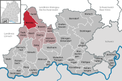
 | ||
| Coordinates: 47°48′04″N 08°02′11″E / 47.80111°N 8.03639°ECoordinates: 47°48′04″N 08°02′11″E / 47.80111°N 8.03639°E | ||
| Country | Germany | |
| State | Baden-Württemberg | |
| Admin. region | Freiburg | |
| District | Waldshut | |
| Government | ||
| • Mayor | Rolf Schmidt | |
| Area | ||
| • Total | 38.04 km2 (14.69 sq mi) | |
| Population (2015-12-31)[1] | ||
| • Total | 1,976 | |
| • Density | 52/km2 (130/sq mi) | |
| Time zone | CET/CEST (UTC+1/+2) | |
| Postal codes | 79872 | |
| Dialling codes | 07675 | |
| Vehicle registration | WT | |
| Website |
www | |

Bernau is a municipality in the district of Waldshut in Baden-Württemberg in Germany.
Geography
Bernau is located in a high valley in the southern Black Forest, south of the Feldberg and west of the Schluchsee. Bernau includes the valley Bernauer Alb, a source stream of the Alb, and extends from 800 meters above sea level up to 1415 meters high.
Neighboring communities
The municipality is bordered to the north by the municipality of Feldberg, in the east by Menzenschwand and the city of St. Blasien, in the south of Ibach, in the southwest of Todtmoos and on the west by the city of Todtnau in the district of Lörrach.
Weather
The annual rainfall is 1919 mm. The driest month is September; most precipitation falls in December. In the wettest month, rain falls about 1.9 times more than the driest month. The temperatures are quite cool with -2.5 °C in January and 13.9 °C in July, and in the morning lower temperatures than on the Feldberg in Bernau are usually measured. The place is one of the snowiest of the Black Forest. Here the snow nearly two meters high was in the winter of 2006.
Monthly average temperatures and precipitates for Bernau (928m) [3]
|
History
The colonization of today's municipal area began in late 11th century with deforestation and construction of courts by lay brothers of the monastery of St. Blasien. The first mention was made in 1157 at the inauguration of a chapel in the district court. With the secularization of the monastery St. Blasien 1806, the centuries-old monastery rule while the membership ended on Front Austria, the place came to the newly created Grand Duchy of Baden.
1922 built the church together with the wooden goods works Präg GmbH in Präg the E-Werk Wacht, which then supplied the wood works and all residents of the community with electric energy. 1934 four independent municipalities of Bernauer valley, Bernau-Innerlehen (with Riggenbach and Schwendele), Hof, Bernau-Dorf with Goldbach and Bernau-Except feudal united (with the Imperial House, Altenrond, Oberlehen, Gass, Unterlehen and Weierle) to the community Bernau. Since then the town was essentially unchanged, using the Baden-Württemberg territorial reform in the 1970s away. The renaming in Bernau im Schwarzwald was carried out on 1 January 1999. [4]
Politics
Council
The council has 10 members in Bernau. The local elections on 25 May 2014 led to the following official results. The turnout was 67.3% (2009: 70.8%). The council consists of the elected honorary councilors and the mayor as chairman. The mayor is entitled to vote in the municipal council.
| Citizens for Bernau | 41.8% - 4 seats, | 2009: 4 seats |
| CDU | 36.1% - 4 seats, | 2009: 3 seats |
| CDU | 22.1% - 2 seats, | 2009: 3 seats |
Culture and sights
- Thoma Showroom
- Resenhof
Museums
- The Hans-Thoma-Kunstmuseum exhibits paintings, graphics and other works and documents by Hans Thoma. In addition, the museum presents works of the respective Hans-Thoma-Prizewinner and of Karl Hauptmann.
- The museum Resenhof, set in a 1789 built high black forest farm, provides an insight into the life and work of people in the Bernauer Hochtal of the 19th century.
Sports
Nearly 100 kilometers of well-marked hiking trails open up the 900 meter high and eight kilometers long high valley for hikers. The friends of Nordic walking are offered specially designated routes and mountain bikerswill find routes almost any level of difficulty. A flight school offers courses in paragliding on.
Even on winter sports almost everything is possible, downhill, slalom, snowboarding, and sledding. Five ski lifts and a ski school professional of the German Ski Instructors' Association are the friends of alpine sportsavailable. For cross-country skiers there are several cross-country ski trails, depending on snow conditions up to 32 kilometers in length.
In place of the football club FC Bernau that Skizunft SZ Bernau and Tennis Club TC Bernau exist. In winter, in Bernau and Todtmoos regularly sled dog races with international participation.
Economy and infrastructure
Traditionally, lived Bernauer of the country - and forestry and wood processing. Especially the wood carving has a long tradition. Manufactured were mainly in the winter months at first commodities like cooking spoons, wooden vessels, chip baskets and boxes. Later, wooden toys and craft items were added.
The sometimes extreme and erosion-prone hillsides made agriculture difficult, low yields and virtually non-mechanized. So already sat early in the 1930s, the structural transformation a, which after the Second World War strengthened continued - away from agriculture and towards tourism. The snow-sure location of the Black Forest allows almost year-round tourist season. 1960 was the first ski lift put into operation today (2006) there are six lifts, including two floodlit and four with snowmaking facilities.
Personalities
Sons and daughters of the city
- Hans Thoma (1839-1924), painter and graphic artist, was born in Oberlehen, grew up there and in 1909 was appointed an honorary citizen of Bernau.
- Ernst Koepfer (1878-1954), ski pioneer and founder of the company Karl Köpfer sons [5]
References
- High jump↑ Federal Statistical Office - municipalities in Germany with population on 31 December 2013 (XLS file, 4.0 MB) (Fort Written official population figures based on the 2011 Census) (help to).
- Jumping Up↑ The State of Baden-Württemberg. Official description after circles and municipalities. Volume VI: Region of Freiburg Kohlhammer, Stuttgart 1982, ISBN 3-17-007174-2. S. 1012-1013
- High jump↑ http://www.klimadiagramme.de
- High jump↑ StBA: changes in the communities in Germany, see 1999
- High jump↑ ski-koepfer.de: Ski Köpfer, access 25 February 2012
References
External links
- Official website (German)
- Bernau: History & Images (German)