Beyers Lakes
| Beyers Lakes | |
|---|---|
 | |
| Location | Nevada County, California[1] |
| Coordinates | 39°23′06″N 120°33′18″W / 39.38500°N 120.55500°W[1]Coordinates: 39°23′06″N 120°33′18″W / 39.38500°N 120.55500°W[1] |
| Basin countries | United States |
| Surface elevation | 6,860 feet (2,090 m)[1] |
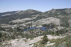
The Beyers Lakes are located in the Tahoe National Forest, in California.
They can be accessed via the Beyers Lakes Trail from Grouse Ridge Trail. Grouse Ridge trail can be accessed from the Eagle Lakes trailhead, off of Interstate 80, or from Grouse Ridge Campground.
They sit below the Black Buttes of Grouse Ridge, and are part of the Fordyce Creek watershed draining into Lake Spaulding.
See also
References
This article is issued from Wikipedia - version of the 2/21/2016. The text is available under the Creative Commons Attribution/Share Alike but additional terms may apply for the media files.