Big Diomede
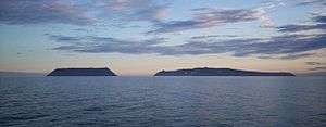
.jpg) Satellite image, Big Diomede on the left, Little Diomede on the right | |
| Geography | |
| Location | Bering Sea |
| Coordinates | 65°46′52″N 169°03′25″W / 65.78111°N 169.05694°W |
| Area | 29 km2 (11 sq mi) |
| Administration | |
| Demographics | |
| Population | 0 |
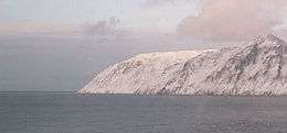
Big Diomede Island (Russian: о́стров Ратма́нова, ostrov Ratmanova (Russian for Ratmanov Island);[1] Inupiat: Imaqłiq) or "Tomorrow Island" (due to the International Date Line) is an island among the Diomede Islands in the middle of the Bering Strait. The island is a part of the Chukotsky District of the Chukotka Autonomous Okrug of Russia.
Geography
Big Diomede Island is located about 45 km (28 mi) southeast of Cape Dezhnev on the Chukchi Peninsula and is Russia's easternmost point. The coordinates are 65°46′52″N 169°03′25″W / 65.78111°N 169.05694°WCoordinates: 65°46′52″N 169°03′25″W / 65.78111°N 169.05694°W. The rocky tuya-type island has an area of about 29 km2 (11 sq mi)[2] The International Date Line is about 1.3 km (0.81 mi)[3] east of the island.
History
The island was originally inhabited by Inupiat. The First Alaskans Institute[4] says that, "The people of the Diomede and King Islands are Inupiat...".
The first European to reach the islands was the Russian explorer Semyon Dezhnyov in 1648. The Danish navigator (in Russian service) Vitus Bering re-discovered the Diomede Islands on August 16, 1728, the day on which the Russian Orthodox Church celebrates the memory of the martyr St. Diomede.[5]
In 1732, the Russian geodesist Mikhail Gvozdev plotted the island's map.
In 1867, during the Alaska Purchase, the new border between the nations was drawn between the Big Diomede and Little Diomede islands.
20th century
During World War II, Big Diomede became a military base, and remained so for some time into the Cold War.[6]
After World War II, the native population was forced off Big Diomede Island to the mainland in order to avoid contacts across the border. Today, unlike Alaska's neighboring Little Diomede Island, it has no permanent native population, but it is the site of a Russian weather station and a base of Russian Border Guard troops (FSB).[7][8]
During the Cold War, the section of the border between the USA and the USSR separating Big and Little Diomede became known as the "Ice Curtain". In 1987, however, Lynne Cox swam from Little Diomede to Big Diomede (approx. 2.2 miles (3.5 km)) and was congratulated jointly by Mikhail Gorbachev and Ronald Reagan.
Fauna
Eleven species of birds have been found on Big Diomede. In 1976 a rufous hummingbird was identified on the island.[9] This finding, unique so far in Russia, was very likely due to a dispersed specimen. Bowhead and gray whales inhabit the waters around the island.
See also
References
- ↑ ru:Ратманов, Макар Иванович
- ↑ "Diomede Islands". Funk & Wagnalls New Encyclopedia. World Almanac Education Group. 2006. Archived from the original on 2009-03-26.
- ↑ Wikimapia
- ↑ Bering Straits, First Alaskans Institute, Regional Fact Sheets
- ↑ Russia.com
- ↑ "Diomede – Inalik, Alaska". Usgennet.org. Retrieved 2012-03-24.
- ↑ Diomede Islands, britannica.com
- ↑ "Google Maps". Maps.google.com. 1970-01-01. Retrieved 2012-03-24.
- ↑ Newfield, Nancy L.; Nielsen, Barbara (1996). Hummingbird Gardens: Attracting Nature's Jewels to Your Backyard. Houghton Mifflin Harcourt. pp. 53–. ISBN 1-881527-87-5.