Big Smoky Valley
| Big Smoky Valley | |
| Valley | |
 Big Smoky Valley | |
| Country | United States |
|---|---|
| State | Nevada |
| Region | Northern and Southern Big Smoky Valley watersheds |
| Location | saddle of drainage divide (south of the Hadley Airport) |
| - coordinates | 38°39′52″N 117°10′16″W / 38.664436°N 117.171078°WCoordinates: 38°39′52″N 117°10′16″W / 38.664436°N 117.171078°W |
| Area | 4,960 sq mi (12,846 km2) [1] (watersheds' area) |
 Location of Big Smoky Valley in Nevada
| |
Nevada Historical Marker | |
| Reference no. | 42[2] |
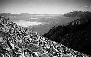
The Big Smoky Valley is a landform of the Tonopah Basin between the Toiyabe and Toquima mountain ranges. It is about 100 miles (160 km) in length, and is known by other names (some with different spellings): including Great Smoky Valley, Smokey Valley, Smoky Valley, Wen-A-No-Nu-Fee Valley, and Won-A-No-Nu-Fee Valley. The U.S. Geological Survey usually refers to it as "Big Smoky Valley," but the chamber of commerce in the valley calls itself the Greater Smoky Valley Chamber of Commerce.
Approximately 2,500 people live in the valley, which has seven small communities. There is an open-pit gold mine at the southern end of the valley, and local industry includes mining, agriculture, and ranching. The valley traverses three counties: Esmeralda, Nye, and Lander. Average yearly precipitation in most of the valley is less than 10 inches (25 cm). The North and South Twin Rivers flow into the Big Smoky Valley—the latter at an elevation of 6,401 feet (1,951 m)—and the water is completely diverted except during periods of high flow.[3]
References
- ↑ "Boundary Descriptions and Names of Regions, Subregions, Accounting Units and Cataloging Units". United States Geological Survey. Retrieved August 22, 2010.
- ↑ Nevada Historical Marker 42
- ↑ "South Twin River near Round Mountain, Nevada (Station 10249300)". United States Geological Survey. Retrieved May 13, 2013.
- A History of Smoky Valley Nevada, by Robert D. McCracken (1997) (ISBN 0-9652908-2-4)
- U.S. Geological Survey Geographic Names Information System: Big Smoky Valley
- Photographs of the Big Smoky Valley