Birmingham Wholesale Markets
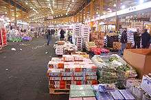
The Birmingham Wholesale Markets are the largest combined wholesale food markets in the United Kingdom,[1] with 235 trading units totalling 31,000 m2 (330,000 sq ft).[2] Located just south of the Bull Ring in the centre of Birmingham, they include markets selling meat, fish, poultry, fruit, vegetables and flowers and are run by Birmingham City Council under a charter granted in 1166.[3]
History
Birmingham's wholesale food markets date from 1166, when the Lord of the Manor Peter de Birmingham obtained a royal charter permitting him to hold a market at "his castle at Birmingham", though later members of the de Birmingham family claimed that markets in Birmingham had been held since before the Norman Conquest.[4] It was this market that provided the first impetus to the growth of Birmingham as a commercial town from the twelfth century onwards.[5] Until the nineteenth century the markets were held throughout the streets of the centre of the town: a cornmarket and Welsh and English markets selling cattle are recorded in 1553, with butchers shambles and a fish market recorded from the eighteenth century.[4]
The organisation of the market was one of the main concerns of the Birmingham Street Commissioners following their establishment in 1769, with the body taking on responsibility for the collection of tolls in 1806 and buying the marketing rights outright from the Lord of the Manor in 1824, before handing responsibility to the Birmingham Corporation in 1854.[4] In the early nineteenth century the clearance of buildings from the Bull Ring allowed the concentration of the markets on the site. In 1817 the Street Commissioners opened the Smithfield market on the site of the Birmingham Manor House, new wholesale fruit and vegetable markets opened on Moat Row in 1883,[6] and the pig and cattle trades moved to a new market in Montague Street between 1892 and 1898.[4] The wholesale fish market in Bell Street was opened in 1869 and extended in 1883, while in 1897 a new meat market with an attached slaughterhouse was opened in Bradford Street.[4]
Increasing congestion in the markets area, coupled with the demolition of the Fish Market for the construction of the Bull Ring Centre in 1958 and the increasing inadequacy of the Smithfield and City Meat markets, led to post-war plans to develop a new wholesale market complex. The first phase of the current market buildings opened in February 1974.[6]
Current markets
The current market includes a 25,300 m2 (272,000 sq ft) horticultural market, a 3,500 m2 (38,000 sq ft) meat market and a 3,000 m2 (32,000 sq ft) fish and poultry market. The markets are open from 4am every day apart from Sunday and receive 13,000 customer visits per week.[7]
Proposed move
Birmingham City Council has plans to move the wholesale markets to a new larger site at Witton, with the current site in Birmingham City Centre being redeveloped under the Big City Plan.[1][3]
References
- 1 2 Dale, Paul (2009-03-03). "Birmingham Council set to give green light to Digbeth market scheme". Birmingham Post. Retrieved 2009-10-29.
- ↑ "Bull Ring Markets". Birmingham City Council. Retrieved 2009-10-29.
- 1 2 Tyler, Jane (2009-05-18). "Birmingham Wholesale Markets move still on track". Birmingham Post. Retrieved 2009-10-29.
- 1 2 3 4 5 Reynolds, Susan (1964) [1955]. "Markets and Fairs". In Stephens, W. B. The City of Birmingham. A History of the County of Warwick. 7. Oxford: Oxford Universoty Press. pp. 251–252. Retrieved 2009-10-29.
- ↑ Holt, Richard (1986). The early history of the town of Birmingham, 1166-1600. Dugdale Society Occasional papers. 30. Oxford: Printed for the Dugdale Society by D. Stanford, Printer to the University. pp. 3–7. ISBN 0-85220-062-5.
- 1 2 "Markets Wholesale Markets History". Birmingham City Council. Retrieved 2009-10-29.
- ↑ "Wholesale Market - Buying and Selling". Birmingham City Council. Retrieved 2009-10-29.
Coordinates: 52°28′29″N 1°53′33″W / 52.4747°N 1.8924°W