Bixby Creek Bridge
| Bixby Creek Bridge | |
|---|---|
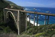
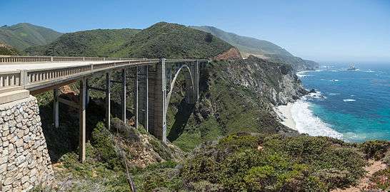 Bixby Creek Bridge from its northern end | |
| Coordinates | 36°22′17″N 121°54′07″W / 36.37139°N 121.90194°WCoordinates: 36°22′17″N 121°54′07″W / 36.37139°N 121.90194°W |
| Carries |
|
| Crosses | Bixby Creek |
| Locale |
Big Sur Monterey County |
| Maintained by | Caltrans |
| Characteristics | |
| Design | reinforced concrete open-spandrel arch bridge |
| Total length | 714 feet (218 m)[1] |
| Width | 24 feet (7 m) |
| Height | 280 feet (85 m) |
| Longest span | 360 feet (110 m)[1] |
| Clearance below | 260 feet (79 m)[1] |
| History | |
| Construction begin | August 24, 1931 |
| Construction end | October 15, 1932 |
| Opened | November 27, 1932 |
| Statistics | |
| Daily traffic | 4,500[2] |
 Bixby Creek Bridge Location in California | |
Bixby Creek Bridge, also known as Bixby Bridge, on the Big Sur coast of California, is one of the most photographed bridges in California due to its aesthetic design, "graceful architecture and magnificent setting."[3][4] It is a reinforced concrete open-spandrel arch bridge. The bridge is 120 miles (190 km) south of San Francisco and 13 miles (21 km) south of Carmel in Monterey County along State Route 1.
Prior to the opening of the bridge in 1932, residents of the Big Sur area were virtually cut off during winter due to the often impassable Old Coast Road that led 11 miles (18 km) inland. At its completion, the bridge was built under budget for $199,861 (equivalent to $3.5 million in 2015) and was the longest concrete arch span at 360 feet (110 m)[1] on the California State Highway System. It is one of the tallest single-span concrete bridges in the world.[5]
History
After the native Esselen people who resided in the area were virtually exterminated by the Spanish,[6]:114 the land from present day Carmel south to Palo Colorado Canyon, two miles north of Bixby Creek, was part of the Mexican land grant Rancho San Jose y Sur Chiquito given in 1839 by Governor Juan Alvarado to Marcelino Escobar. The land was later acquired by José Castro. He had a trail built from Monterey to Palo Colorado Canyon as early as 1853, when he filed a map of his purchase.[7][8]
Originally Mill Creek
Bixby Creek is named after pioneering businessman Charles Henry Bixby. Originally from Livingston County, New York, he arrived in California in 1852 and remained for five years. He returned east before coming back to California. After some success raising cattle in Sonoma County, he obtained a patent on April 10, 1889 for 160 acres south of Bixby Creek,[9] and later bought additional tracts of land on the north side of the creek, between it and Palo Colorado Canyon. He built a sawmill on the creek, which for many years was known as Mill Creek. He harvested timber and turned it into shakes, shingles, railroad ties, and trench posts. He also harvested the bark of the Tanbark Oak which was used for tanning cow hides. Bixby discovered lime deposits on Long Ridge above Mill Creek. He used mules to haul the lime to the coast on wooden sleds. He had kilns built and sold the fired lime as use in mortar and other building materials.[4]
He tried to persuade the county to build a road to Bixby Creek, but they refused, replying that "no one would want to live there." It was impossible to build a wharf from the cliffs that dropped into the ocean, and he instead built a hoist that could be used to ferry goods to and from ships anchored slightly offshore.[10][11] In 1870, Bixby and his father hired men to improve the track and constructed the first wagon road including 23 bridges from the Carmel Mission to Bixby Creek.[12]
Sometime later Bixby partnered with William B. Post and extended the road south to his ranch. At Bixby Creek, the road was necessarily built 11 miles (18 km) inland to circumvent the deep canyon. It then led to the Post Ranch on the Rancho El Sur.[11][8]:4–2 The 30-mile (48 km) trip could take three days by wagon or stagecoach.[13]:24 The single-lane road was closed in winter when it became impassable. Coast residents would occasionally receive supplies via a hazardous landing by boat from Monterey or San Francisco.[8]:4–4

In 1906, after he exhausted the supply of commercial timber, Bixby sold the land to the Monterey Lime Company. Lime was in great demand to help re-build San Francisco following the 1906 earthquake. That company built a 3 miles (4.8 km) aerial tram to haul limestone from Long Ridge to Bixby Landing. A small group of homes grew up around the original Bixby Homestead. The kilns operated for four years until high operating costs closed the kilns in 1910. The tram was used for a while longer to off and on-load supplies for the community from schooners.[14]
Brazil Ranch

The former Brazil Ranch is located on Serra Hill immediately south of Bixby Creek and the Bixby Creek Bridge, making it one of the most photographed spots on the Big Sur coast. Job Heath obtained a land patent on May 20, 1884 and he and his wife Serena Waters homesteaded the ranch.[15] Antonio Brazil married Mary Pfeiffer and they bought Heath's property.[16]
The Brazil family operated the 1,255 acres (508 ha) ranch for nearly a century. In 1977, Tony and Margaret Brazil sold the ranch to Allen Funt, creator of the television show Candid Camera. Funt raised quarter horses and cattle on it.
Proposed development
In 1986 the Humboldt County-based Philo Lumber Company owned the property formerly owned by Bixby. They obtained a state permit to log over a million board feet of redwood. The residents of Palo Colorado Canyon were intensely opposed to the plan, but it was only derailed by the savings and loan crisis. The property was seized by federal financial regulators and was later sold to the Big Sur Land Trust, which then sold it to the Monterey Peninsula Regional Park District in 1988. The district joined it with three adjacent properties to form the Mill Creek Redwood Preserve.[14]
A 2.7 mile trail has been built from Palo Colorado Road to an overlook. Access is limited to day use. The trail head is located 6 miles (9.7 km) up Palo Colorado Road from the coast. Visitors must obtain a permit from the district in advance to visit the preserve. To limit traffic on narrow Palo Colorado Road, only six permits per day are available.[14][11]
After Funt died in 1999, the former Brazil Ranch land was purchased in 2000 by Woodside Partners, who planned to split it into nine parcels for development. Local community leaders and activists joined together to prevent subdivision and development of the land. In 2001, the Trust for Public Land bought the property. On September 24, 2002, they and the U.S. Forest Service announced that the land had been added to the Los Padres National Forest.[17] The unmarked entrance is located .1 miles (0.16 km) south of the Bixby Creek Bridge.[18][12]
Construction
The state first began building Route 56, or the Carmel-San Simeon Highway, in 1919. A number of bridges needed to be constructed, the largest among them across Bixby Creek.[10]
Bridge location
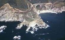
State engineers considered two alternatives to crossing the creek, an inland route and a smaller bridge, or a coastal location and a larger bridge. The inland route necessitated an 890-foot (270 m) tunnel cutting though the Santa Lucia Mountains to a 250-foot (76 m) bridge upstream.[10] The engineers selected the coast route, because it was safer, more scenic, and least affected the environment.
California state highway engineer C. H. Purcell and bridge engineer and designer F. W. Panhorst considered whether to build a steel or concrete span. A steel bridge would cost more to build and maintain, as the sea air would require expensive ongoing maintenance and painting. A steel bridge was also less in keeping with the natural environment. Using concrete reduced material costs and allowed more of the total cost to be paid to workers, which was a positive aspect of the design during the Depression.[3] They chose concrete in part because it would not only reduce both construction and maintenance costs but would also echo the color and composition of the natural rock cliff formations in the area.[19]
The state awarded a contract for $203,334 to the lower bidder, Ward Engineering Company of San Francisco, on August 13, 1931.[19] Construction began on August 24, 1931.[19]
Design and materials
Over 300,000 board feet (700 m3) of Douglas fir timber, used to build a 250-foot (76 m) high falsework to support the arch during construction, was transported from the railroad terminal in Monterey over the narrow, one-way road to the bridge site. The falsework, built by crews led by E. C. Panton, the general superintendent, and I. O. Jahlstrom, resident engineer of Ward Engineering Co., was difficult to raise, because it was constantly exposed to high winds. Some of the falsework timbers were 10 by 10 inches (250 mm × 250 mm).[20] It took two months to construct the falsework alone. When high waves threatened the falsework foundation, construction was halted for a short time until winter storms abated.[10]
The crews excavated 4,700 cubic yards (3,600 m3) of earth and rock.[21] Eight hundred twenty-five trucks brought in 600,000 pounds of reinforcing steel.[21] Sand and gravel were supplied from a plant in Big Sur.
Construction required 45,000 sacks or 6,600 cubic yards (5,000 m3) of cement[21] which was transported from Davenport, near Santa Cruz, and from San Andreas.[10] Crews began placing concrete on November 27. The concrete was transported across the canyon on platforms using slings suspended from a cable 300 feet (91 m) above the creek.
The bridge was completed on October 15, 1932,[22] although the highway was not finished for another five years. At its completion, the bridge cost $199,861 and, at 360 feet (110 m), was the longest concrete arch span on the California State Highway System.[19] The bridge was necessary to complete the two-lane road which opened in 1937 after 18 years of construction.[23]
Rainbow Bridge
After the bridge was completed, it was at times known as the Rainbow Bridge, due to the presence of the Rainbow Lodge resort on the creek upstream from the bridge. It was operated by former Army Captain Howard Sharpe and his wife, Frida. After timber harvesting was no longer profitable, Sharpe bought the Bixby Creek Canyon ranch in 1919. He built a dirt road from the lodge up the canyon to Bixby Landing and another road down to the beach at the mouth of Bixby Creek. He sold part of his land to the state as part of the bridge right-of-way in 1930.[10]
Seismic retrofitting
The bridge was retrofitted beginning in 1996 with an analysis by bridge engineering company Buckland & Taylor as part of the Caltrans Phase II seismic retrofit program.[24] In their detailed evaluation of the bridge's seismic vulnerabilities, they were challenged to find a solution that met several difficult issues, including severe load factors, extremely limited physical access, maintaining the appearance of the existing historical structure, and a requirement by the State of California that at least one lane of the bridge remain open at all times. The crux of the design was the longitudinal post-tensioning of the entire bridge deck from end to end.[25]
The $20 million seismic retrofit began in May 1998. The cost of the retrofit was considerably increased by the requirement to preserve the historical look of the bridge.[3] Prime contractor Vahani Construction of San Francisco was assisted by Faye Bernstein & Associates and Waldron Engineering. To reinforce the abutments supporting the bridge deck at either end, engineers put in place a floating slab, continuous with the deck, keyed into a massive pile cap with six 72-inch (1,800 mm) diameter cast-in-drilled-hole (CIDH) piles behind each abutment. To support the towers, engineers designed a full height structural wall that was integrated within each of the two existing towers. During the retrofit, they removed the top portion of the towers, including the roadway, and replaced them with a prestressed diaphragm that anchors the full height of the vertical tower. The diaphragm simultaneously distributes the vertical prestressing forces uniformly to the new concrete structural wall and the existing tower's concrete.[26]
The deck, which curves from one end to the other, was reinforced by adding heavily confined edge beams encasing high strength steel along the inside face of the exterior longitudinal girders underneath. These rods extended from one end of the roadway to the other. The reinforced edge beams ensure continuity across the many expansion joints and help distribute the bending strains due to lateral flexure.[26] In addition to the reinforced edge beam, four large prestressing tendons were installed the length of the bridge along the underside of the deck slab. These tendons are stressed to pre-compress the concrete deck to approximately 800 psi and also serve as flexural reinforcement along with the high strength rods. Finally, engineers found a way to reinforce the bent columns attached to the arch, which possess complex and varying geometric challenges. They encased the bent columns with thin, lightweight, composite carbon fiber jackets that provide the necessary degree of confinement to ensure ductile response and also mimic the original design.[26]
In addition to the analyses performed by Buckland and Taylor, Caltrans commissioned Lawrence Livermore National Laboratory to perform an independent study of the structure both with and without the proposed retrofit measures in place. The final report, which was published in June 1999, concludes that the retrofit appears to be appropriate even for earthquake ground motions including near-field displacement pulses, which were not considered in the original analyses.[27]
As a result of the retrofit, the continuous, stiffened deck has four lateral reaction points: two new massive abutments anchored by large-diameter, cast-in-drilled-hole piles. The two towers are strengthened and anchored to rock with tie-down anchors within the towers. The arch ribs are laterally supported at their crowns by new shear keys that link them to the reinforced deck.[25][28] The expensive retrofit, completed in November 2000, still left the bridge officially classified as "functionally obsolete" because at 24 feet (7.3 m) in width, the bridge is less than the 32 feet (9.8 m) standard required of newly built bridges.[3]
Characteristics
The bridge is 714 feet (218 m) in total length, 24 feet (7.3 m) wide, with 260 feet (79 m) of clearance below, and has a main span of 360 feet (110 m), which places 50% of the total roadbed above the arch.[1] The arch ribs are five feet thick at the deck and nine feet thick at the springing line, where they join the towers at their base. The arches are four and one-half feet wide.[29] The bridge was designed to support more than six times its intended load.[19]
The two large, vertical buttresses or supporting pillars on either side of the arch, while aesthetically pleasing, are functionally unnecessary. Engineers of later arch bridges such as the Frederick W. Panhorst Bridge omitted them from the design.[30] The Rocky Creek Bridge and the Malpaso Creek Bridge to the north are also open-spandrel arch bridges built of reinforced concrete.
In popular culture

The bridge is “one of the most photographed features on the West Coast”[31] due to its pleasing aesthetic design[3] and because of its location along the scenic Central Coast of California. "It is arguably the most photographed stretch of the entire Big Sur Coast, on postcards, TV ads, everywhere," according to Debra Geiler, project manager for the Trust for Public Land. "It's the gateway to Big Sur and the interior has never been logged. The land is pristine." Zad Leavy, former exeutive director of the Big Sur Land Trust, described the land as "...the most spectacular meeting of ocean and land in the entire United States."[32]
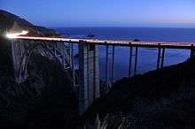
The bridge and adjacent land has frequently been used in automobile commercials. The bridge has become a regional landmark and was used in the opening sequences of the television series Then Came Bronson, the films Play Misty for Me and The Sandpiper. The bridge was also in the seventeenth episode of the first season of the NBC's show Heroes ("Company Man"), even though the scene was set in Texas. The bridge figures prominently in posters and other publicity material of the Big Sur International Marathon. An outline image of the bridge forms the logo for Central Coast ABC, the area's ABC Television Network affiliate on KSBW-TV (Channel 8.2).
The bridge was commemorated in an Express mail stamp issued on February 3, 2010. The United States Postal Service introduced a $18.30 definitive stamp designed by Carl T. Herrman of North Las Vegas, Nevada. The stamp features a color digital illustration of Bixby Creek Bridge in California, by Dan Cosgrove of Clarendon Hills, Illinois.[33]
Bixby Canyon Bridge is the title of the first track of indie rock band Death Cab For Cutie's sixth studio album, Narrow Stairs, released in 2008. The song references lead singer/frontman Ben Gibbard's journey to Big Sur; following in the footsteps of his favourite American writer, Jack Kerouac.

References
- 1 2 3 4 5 Bixby Creek Bridge (1933) at Structurae
- ↑ Bridgehunter – Historic Bridges of the U.S.: Bixby Creek Bridge
- 1 2 3 4 5 Rutherford, M. A. "A Critical Analysis of Bixby Creek Bridge" (PDF). Proceedings of Bridge Engineering 2 Conference 2009 April 2009, University of Bath, Bath, UK. Retrieved December 10, 2012.
- 1 2 Spradling, David (April 21, 2015). "Young Bixby Wagons West". Retrieved September 5, 2016.
- ↑ Craven, Jackie. "Bixby Bridge in Big Sur, California". Retrieved December 9, 2012.
- ↑ Pritzker, Barry M. (2000). A Native American Encyclopedia: History, Culture, and Peoples. Oxford: Oxford Univ. Press. ISBN 978-0-19-513877-1.
- ↑ "Diseño map of Rancho San Jose Y Sur Chiquito" (GLO No. 552 ed.). Monterey County, California. Retrieved 14 August 2016.
- 1 2 3 JRP Historical Consulting Services (November 2001). "Big Sur Highway Management Plan" (PDF). Corridor Intrinsic Qualities Inventory Historic Qualities Summary Report. CalTrans. p. 38. Retrieved November 14, 2009.
- ↑ "Charles H Bixby, Patent #CACAAA-090682". The Land Patents. Retrieved 20 August 2016.
- 1 2 3 4 5 6 Newland, Renee. "Bixby Creek Bridge". Monterey County Historical Society. Retrieved November 13, 2011.
- 1 2 3 Anderson, Corby. "Mill Creek Redwood Preserve Trail taps the serenity of Palo Colorado Canyon.". Monterey County Weekly. Retrieved August 12, 2016.
- 1 2 Walton, John (2007). "The Land of Big Sur Conservation on the California Coast" (PDF). California History. 85 (1). Archived from the original (PDF) on August 22, 2015e. Retrieved 14 August 2016.
- ↑ Elliott, Analise (2005). Hiking & Backpacking Big Sur. Berkeley, California: Wilderness Press.
- 1 2 3 "Mill Creek Redwood Preserve". Monterey Peninsula Regional Park District. Retrieved 5 September 2016.
 This article incorporates text from this source, which is in the public domain.
 - ↑ "Job W Heath Sr, Patent #CACAAA-090653". Land Patents. Retrieved 20 August 2016.
- ↑ Norman, Jeff (2004). Big Sur. Charleston, S.C.: Arcadia Pub. ISBN 978-0738529134. Retrieved 21 August 2016.
- ↑ "Big Sur Coastland Protected". Trust for Public Land. September 24, 2002. Retrieved 21 August 2016.
- ↑ "Brazil Ranch" (PDF). Retrieved August 12, 2016.
- 1 2 3 4 5 Vitousek, Sean. "Big Sur Bixby Bridge". Retrieved November 13, 2011.
- ↑ "Bixby Creek Bridge, Big Sur Coast on Highway One, Calif.". California Views Historical Photo Collection. December 1, 2012. Retrieved December 9, 2012.
- 1 2 3 Longfellow, Rickie (April 7, 2011). "Back in Time". Back in Time. U.S. Department of Transportation, Federal Highway Administration. Retrieved December 16, 2011.
- ↑ California Views: BCB from the Pat Hathaway collection
- ↑ "Bixby Creek Bridge Near Carmel, California, U.S.A.". Buckland & Taylor Ltd. Retrieved December 16, 2011.
- 1 2 Pollock, P.E., Brad. "Safeguarding Bixby Bridge". Retrieved December 10, 2012.
- 1 2 3 Wilson, J. G. "Innovative Techniques for the Seismic Retrofit of Bixby Creek Concrete Arch Bridge" (PDF). P. E. L. Panian. Retrieved December 9, 2012.
- ↑ McCallen, David; Noble, Charles; Hoehler, Matthew (1999). The seismic response of concrete arch bridges – With focus on the Bixby Creek Bridge. Carmel, California (PDF) (Technical report). Lawrence Livermore National Laboratory. UCRL-ID-134419.
- ↑ "Bixby Creek Bridge". Buckland & Taylor. Retrieved December 10, 2012.
- ↑ "Concrete Arch Bridges California Canyon". Popular Mechanics. April 1933.
- ↑ Elliot, Arthur L. (1983), "Esthetic Development of California's Bridges", Journal of Structural Engineering, 109 (9): 2159–2174, doi:10.1061/(ASCE)0733-9445(1983)109:9(2159)
- ↑ California Views: BCB Historical Collection
- ↑ McCabe, Michael. "Land Trust Saves Big Sur Ranch / Developer pockets $24 million after one-year ownership". SFGate. San Francisco Chronicle. Retrieved 17 November 2016.
- ↑ "Bixby Creek Bridge $18.30". US Postal Service. Retrieved December 10, 2012.
External links
| Wikimedia Commons has media related to Bixby Creek Bridge. |
- Pelicannetwork.net: Big Sur Bixby Bridge
- Popular Mechanics (April 1933) — Concrete Arch bridges California Canyon
This article contains content from government publications that are in the public domain.