Black Forest Trail
| Black Forest Trail | |
|---|---|
|
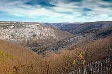
Canyon Vista on the Black Forest Trail (note orange tail blazes) | |
| Length | 42 mi (68 km) |
| Location | Tiadaghton State Forest, Pennsylvania, United States |
| Trailheads | Slate Run, Pennsylvania |
| Use | Hiking |
| Hiking details | |
| Trail difficulty | Strenuous |
| Season | Year-round |
| Sights | Vistas, Pine Creek Gorge |
| Hazards | Severe Weather, Poison ivy, Bears, Rattlesnakes, Ticks |

The Black Forest Trail is a 42-mile (68 km) loop trail that resides in Pennsylvania's Tiadaghton State Forest in parts of Lycoming, Potter, and Clinton Counties. Many other forest roads, hiking, and cross country ski trails cross the Black Forest Trail making it possible to do shorter loops for day hikes or shorter backpacking trips. The Black Forest Trail is known for many steep ascents and descents as well as spectacular views of the Pine Creek Gorge and other canyons to the west.
Marking
As with most long-distance trails in Pennsylvania, the BFT is blazed with orange. Side trails are blazed blue.
Trailheads
The official start of the trail is a short distance from the village of Slate Run (off of Pennsylvania Route 414) on Slate Run Road. The trail can also be accessed from Pennsylvania Route 44, which it crosses twice, north of Waterville, Pennsylvania. In addition the trail crosses several dirt forest roads.
Description
This is a brief description starting counter-clockwise at from the main trailhead at Slate Run. From the trailhead you walk a very short while through a pine plantation. The beginning of the trail crosses the Slate Run stream which is about 30 feet (9 m) wide and has a new foot bridge dedicated on October 24, 2014. You then climb about 1,000 feet (300 m) in a mile and a half. Part way up you come across an old quarry that offers spectacular views of the valley carved by Slate Run Creek. Then next several miles explore the plateau that is the Alcinda wilderness area. This section is generally level. About mile 6 (km 9.7) you descend along the Red Run, passing several nice campsites (including one at the top of the plateau before you descend), finally recrossing the Slate Run around mile 8 (km 13). You then are greeted with another gradual 1,000 feet (300 m) climb, part of which is on an old logging road. The trail once again follows the plateau to the west, with level hiking for the next several miles. The Sentiero Di Shay ski trail cross the BFT twice in this section and can be used to make alternative loops. Around the 13-mile (21 km) mark you cross Pennsylvania Route 44 in a beautiful stand of hemlocks. The trail slowly descends and for the next several miles and follows the County Line Branch stream. This section has many water crossings that can be difficult in high water; campsites can be found in this section with the nicest being around mile 17 (km 27) before you climb out of the valley.
Around mile 17 (km 27) the trail makes a steep climb to the plateau again. For the next 6 miles (9.7 km) the trail follows the plateau with views to the west. The hiking in this section is generally mostly level with a few minor climbs, as well as several nice campsites, especially around mile 21 (km 34). This section of trail also crosses several cross country ski trails that can be used to access Pennsylvania Route 44. Finally around mile 24 (km 39) the BFT recrosses Pennsylvania Route 44. Following the crossing you have another couple miles of level hiking before taking on the much more rugged eastern section of the trail. Around mile 26 (km 42) the trail drops down to Callahan Run (with camping at the bottom), one of many runs that flow into Pine Creek. After dropping down you immediately climb back up (this is the general pattern for the rest of the trail). After climbing up the trail heads to Hemlock Mountain. At the top around mile 29 (km 47) there is a wonderful, dry, mountaintop campsite with spectacular views of Pine Creek. Once again you drop down to Naval Run (nice large campsite at the bottom) and follow this for a little less than a mile before climb again up to the plateau. This particular climb has many outstanding views.
Hazards
Hazards on the trail include the Timber Rattlesnake which are found in reasonable numbers in the area. Although the chances of getting bitten are small, as a matter of caution hikers should pay attention to where they place their hands and feet,especially when scrambling over rock. The trail also includes several very steep climbs. Hikers should be certain they are in the proper physical shape to handle the strenuous terrain. Finally the trail has many unbridged stream crossings, especially on the County Line Branch stream. In periods of high water some crossings require fording. Alternative footwear for crossing streams and other possible water crossings is advisable.
External links
- Pennsylvania DCNR website about the Black Forest Trail
- Description of several hikes on the Black Forest Trail
- Description of the northern half of the trail
- Description of the southern half of the trail
Coordinates: 41°30′31″N 77°29′49″W / 41.50861°N 77.49694°W