Black Mixen
| Black Mixen | |
|---|---|
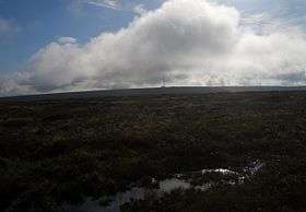 Black Mixen and the communications mast from the Rhos Fawr plateau | |
| Highest point | |
| Elevation | 650 m (2,130 ft) |
| Prominence | 45 m (148 ft) |
| Parent peak | Rhos Fawr |
| Listing | Hewitt, Nuttall, |
| Coordinates | 52°16′18″N 3°10′44″W / 52.2718°N 3.1789°WCoordinates: 52°16′18″N 3°10′44″W / 52.2718°N 3.1789°W |
| Geography | |
| Location | Powys, Wales |
| Parent range | Cambrian Mountains |
| OS grid | SO182639 |
| Topo map | OS Landranger 148 |
Black Mixen (Welsh: Y Domen Ddu) is a subsidiary summit of Rhos Fawr or Great Rhos in the Radnor Forest. The summit is large peat bog plateau. The summit is marked with a cairn, and is next to a radio transmitter and its building.[1]
Black Mixen is the only Nuttall to have a communications mast (a radio transmitter) on its summit .[2] To the east is Bache Hill, to the south are the Black Mountains, to the west is the Great Rhos plateau.
References
- ↑ Nuttall, John & Anne (1999). The Mountains of England & Wales - Volume 1: Wales (2nd edition ed.). Milnthorpe, Cumbria: Cicerone. ISBN 1-85284-304-7.
- ↑ "Pumlumon". Retrieved 2007-04-22.
External links
This article is issued from Wikipedia - version of the 12/14/2015. The text is available under the Creative Commons Attribution/Share Alike but additional terms may apply for the media files.