Black River (Chehalis River)
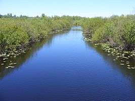
The Black River is a river in Thurston County in the U.S. state of Washington. It is approximately 25 miles (40 km) long with a drainage basin of about 144 square miles (370 km2).[1] The Black River's source is Black Lake, located about 3 miles (4.8 km) west of Tumwater. The river flows generally south, through the Mima Mounds State Natural Area, then southwest, passing by Rochester and entering Grays Harbor County, then emptying into the Chehalis River in the Chehalis Indian Reservation.[2]
The fur trader John Work was the first to describe the Black River in 1824: The Black River so named from the colour of its water . . . A great many dead salmon are in the river, and many that are just alive and barely able to move through the water.[3]
The Black River Unit of the Nisqually National Wildlife Refuge extends about 5 miles (8 km) along the river immediately south of Black Lake.
See also
References
- ↑ "Chehalis River Basin Nonpoint Action Plan - Black River". Chehalis River Council. Retrieved 2009-06-05.
- ↑ Course info mainly from: Washington Road & Recreation Atlas. Benchmark Maps. 2000. and
- ↑ Majors, Harry M. (1975). Exploring Washington. Van Winkle Publishing Co. p. 116. ISBN 978-0-918664-00-6.
External links
Coordinates: 46°49′16″N 123°13′10″W / 46.82111°N 123.21944°W