Blackfoot Mountains
| Blackfoot Mountains | |
|---|---|
 Taylor Mountain (Bingham County, Idaho) | |
| Highest point | |
| Peak | Taylor Mountain (Bingham County, Idaho) |
| Elevation | 2,220 m (7,280 ft) |
| Coordinates | 43°18′19″N 111°55′18″W / 43.30528°N 111.92167°W |
| Geography | |
| Country | United States |
| Provinces/States | Idaho |
| Range coordinates | 43°11′N 111°50′W / 43.18°N 111.83°WCoordinates: 43°11′N 111°50′W / 43.18°N 111.83°W |
| Parent range | Rocky Mountains |
The Blackfoot Mountains, also called the Blackfoot Range, is a small range of mountains located east of Blackfoot, Idaho. Most of the area is private property, including the range's tallest mountain, Taylor Mountain. This mountain was named after Sam Taylor, an early settler and brother of Matt Taylor.[1] The Blackfoot River carves through the region. Within this range is Wolverine Canyon, a public area that features sites for hiking, camping, kayaking, rock climbing and other recreational pursuits.
Ecology
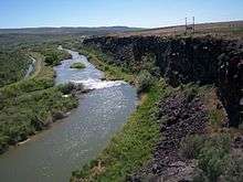
Wolverine Canyon is the result of Wolverine Creek eroding the mainly black basalt of the Blackfoot Mountains.
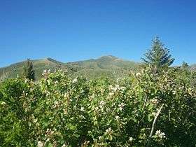
The Blackfoot Mountains as seen from near Iona, Idaho
This area is mainly a hilly shrub-steppe, covered in sagebrush and juniper. However, there are many springs and small streams which form microclimates with more water-loving plants. The mountains themselves are mainly basalt.
References
- ↑ Otteson, Connie B. (2005), Unsung Heroes and Settlers of Bonneville County, Idaho, Harris Publishing Company, Inc
This article is issued from Wikipedia - version of the 5/26/2015. The text is available under the Creative Commons Attribution/Share Alike but additional terms may apply for the media files.