Block 11
| Block 11 Auschwitz concentration camp | |
|---|---|
|
View of Block 11 (left) as seen from the site of the reconstructed death wall | |
|
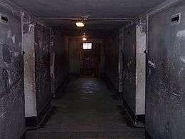
Corridor of Block 11 |

Block 11 was the name of a brick building in the Auschwitz concentration camp. The Block was in the so-called Stammlager (Auschwitz I main camp) and was intended solely to punish prisoners through torture. Between the tenth and eleventh block stood the death wall (reconstructed after the war) where thousands of prisoners were lined up for execution by firing squad.[1] The block contained special torture chambers in which various punishments were applied to prisoners. Some could include being locked in a dark chamber for several days or being forced to stand in one of four standing cells.[2] Punishment in these special compartments (one square metre each, with a hole 5x5 cm for breathing), consisted of confining four prisoners, who were forced by the lack of space to remain standing all night for up to twenty nights, while still being forced to work during the day.[3]
It was at Block 11 that the first attempts to kill people with Zyklon B were implemented.[1]
Interrogations
Prisoner interrogations involving extreme torture were also conducted within Block 11, often with use of the "Boger Swing" device,[4] (Boger-Schaukel) invented by Wilhelm Boger, an SS officer who served within Auschwitz's Political Department.[5]
References
- 1 2 Block No. 11. Jewish Virtual Library
- ↑ Auschwitz-Birkenau - Punishments and executions. Auschwitz.org
- ↑ Jacek Lachendro (2013). "Blok 11 . Kary i egzekucje (Block 11. Punishments and executions)" (in Polish). Państwowe Muzeum Auschwitz-Birkenau w Oświęcimiu. pp. 1 of 10. Retrieved February 2, 2013.
- ↑ "Paul Leo Seidel, of Munich, former inmate of the Auschwitz Extermination Camp, displays a model of the 'Boger Swing.'". WWII-Holocaust. Pinterest photo archive. Retrieved 1 March 2014.
- ↑ "Wilhelm Boger: Auschwitz - Political Department". Holocaust Education & Archive Research Team. Archived from the original on May 5, 2012. Retrieved March 1, 2014.
External links
 Media related to Auschwitz I death block 11 at Wikimedia Commons
Coordinates: 50°01′30″N 19°12′13″E / 50.0251°N 19.2035°E