Blyth Bridge

Coordinates: 55°41′42″N 3°22′34″W / 55.695°N 3.376°W
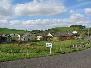
Blyth Bridge is a small hamlet in the Scottish Borders area of Scotland, near to West Linton.
It is located in a bend on the A701 which goes from Moffat to Edinburgh, close to the junction with the East-West road the A72 which goes to Peebles.
Places nearby include the Lyne Water, Carlops, Romannobridge, and the Deepsyke Forest.
There is an aqueduct carrying a large water main which supplies Edinburgh and passes over Tarth Water.
There are a number of iron age forts on the hills nearby, and the historic Drochil Castle is a short distance away.
Blythbank Farm nearby currently has a planning permission application to make it the largest free range egg farm in the world.[1]
See also
References
- ↑ "Villagers Stunned at Government Decision". Blyth Bank Action Group. 2008-03-26. Retrieved 2008-04-01.
External links
| Wikimedia Commons has media related to Blyth Bridge, Scottish Borders. |
- RCAHMS: Blyth Bridge, Blyth Mill
- PDF document from Scottish Borders Council
- Gazetteer for Scotland: Blyth Bridge
- Blythbank Action Group
- Newlands Community Development Trust