Bocaina Mosaic
| Bocaina Mosaic | |
|---|---|
| Mosaico Bocaina | |
|
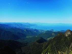
View from the Pedra da Macela on the RJ/SP border | |
 | |
| Nearest city | Paraty, Rio de Janeiro |
| Coordinates | 23°17′13″S 44°44′20″W / 23.287°S 44.739°WCoordinates: 23°17′13″S 44°44′20″W / 23.287°S 44.739°W |
| Area | 221,754 hectares (547,970 acres) |
| Designation | Protected area mosaic |
| Created | 11 December 2006 |
The Bocaina Mosaic (Portuguese: Mosaico Bocaina) is a protected area mosaic on the border between the states of Rio de Janeiro and São Paulo in Brazil. It provides coordinated management for a group of ten federal, state and municipal conservation units covering an area of Atlantic Forest along the coast and up the slopes of the Bocaina plateau.
Creation
A project to create three new protected area mosaics in the Serra do Mar Ecological Corridor began in December 2005, coordinated by the National Council of the Atlantic Forest Biosphere Reserve. These were the Bocaina Mosaic, Central Rio de Janeiro Atlantic Forest Mosaic and Mantiqueira Mosaic. Funding was provided by Conservation International, the Fund for the Global Environment Facility (GEF), the Government of Japan, the MacArthur Foundation and the World Bank.[1]
The Bocaina Mosaic was created by the ministry of the environment by decree 349 of 11 December 2006.[2] The mosaic acquired its formal structure in March 2007. The purpose is to give integrated management of different conservation units in the region, including federal, state, municipal and private units, which may be different types of strictly protected or sustainable use unit.[1]
Extent and purpose
The Bocaina Mosaic has an area of 221,754 hectares (547,970 acres) and contains 10 conservation units and their buffer zones on the southern coast of Rio de Janeiro and the northern coast of São Paulo.[3] It ranges from coastal areas through steep slopes to the top of the dissected Bocaina plateau at an altitude of 2,088 metres (6,850 ft). It is one of the main strongholds of Atlantic Forest vegetation, covered by dense rain forest (submontane, montane and high montane), high montane araucaria forest, alpine meadows, marine coastal and island ecosystems. The environment is still in good condition despite many places where humans have interfered.[2]
The Bocaina Mosaic aims to encourage integrated management of the various protected areas, contributing to the preservation and conservation of natural and fishing resources as well as sustainable development of the territory. It is included in the Atlantic Forest Biosphere Reserve recognized by UNESCO. The mosaic has an advisory board with representation of government agencies and civil society to provide integrated management of the conservation units and their buffer zones.[2]
Conservation units
The conservation units include:[2]
| Name | Level | Created | State | Area (ha) |
|---|---|---|---|---|
| Aventureiro Sustainable Development Reserve[lower-alpha 1] | State | 1990 | Rio de Janeiro | 1,300 |
| Paraty Bay, Paraty-Mirim and Saco do Mamanguá Environmental Protection Area | Municipal | 1984 | Rio de Janeiro | 3,070 |
| Bananal Ecological Station | State | 1987 | Rio de Janeiro | 884 |
| Cairuçu Environmental Protection Area | Federal | 1983 | Rio de Janeiro | 33,800 |
| Ilha Anchieta State Park | State | 1977 | São Paulo | 830 |
| Praia do Sul Biological Reserve | State | 1981 | Rio de Janeiro | 3,600 |
| Serra da Bocaina National Park | Federal | 1972 | Rio de Janeiro São Paulo | 97,953 |
| Serra do Mar State Park (includes the Cunha and Santa Virgínia nuclei) | State | 1977 | São Paulo | 47,500 |
| Tamoios Ecological Station | Federal | 1990 | Rio de Janeiro | 8,700 |
| Tamoios Environmental Protection Area | State | 1986 | Rio de Janeiro | 90,000 |
Notes
Sources
- "Corredor ecológico da Serra do Mar", Acervo da Folha do Meio (in Portuguese), FMA: Folha do Meio Ambiente, 20 December 2006, retrieved 2016-09-22
- Lino, Clayton Ferreira; Albuquerque, João Lucílio; Dias, Heloisa (2007), Mosaicos de unidades de conservação no Corredor da Serra do Mar (PDF) (in Portuguese), São Paulo: Conselho Nacional da Reserva da Biosfera da Mata Atlântica, retrieved 2016-09-22
- Mosaico de Unidades de Conservação da Bocaina - SP e RJ (PDF) (in Portuguese), RBMA, retrieved 2016-09-22
- "Reserva de Desenvolvimento Sustentável do Aventureiro - Ilha Grande - Angra dos", ilhagrande.org (in Portuguese), retrieved 2016-09-23