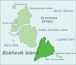
Bolshevik Island
| Native name: <span class="nickname" ">о́стров Большеви́к | |
|---|---|
 Bolshevik Island, Russia | |
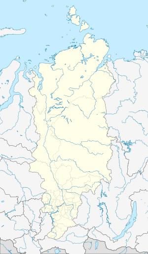 Bolshevik Island Bolshevik Island in Krasnoyarsk Krai, Russia | |
| Geography | |
| Location | Arctic |
| Coordinates | 78°37′48″N 102°28′50″E / 78.630006°N 102.480469°ECoordinates: 78°37′48″N 102°28′50″E / 78.630006°N 102.480469°E |
| Archipelago | Severnaya Zemlya |
| Area | 11,270 km2 (4,350 sq mi)[1] |
| Area rank | 66th[1] |
| Highest elevation | 935 m (3,068 ft) |
| Highest point | unnamed |
| Administration | |
|
Russia | |
Bolshevik Island (Russian: о́стров Большеви́к, pronounced [ˈostrəf bəlʲʂɨˈvʲik]) is an island in Severnaya Zemlya, Krasnoyarsk Krai, Russian Arctic.
History
The island, together with the eastern coast of what was named Emperor Nicholas II Land, was discovered by Boris Vilkitsky at the time of the 1913 Arctic Ocean Hydrographic Expedition. Its insularity, however, wasn’t proven until 1931, when Georgy Ushakov and Nikolay Urvantsev charted the archipelago during their 1930–32 expedition.[2]
Geography
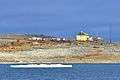
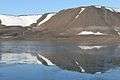
It is the southernmost island and the second largest island in the group. The area of this island has been estimated at 11,270 km².[1] The island is mountainous reaching a height of 935 m, and it houses an arctic base named Prima. About 30% of the island is covered by glaciers, while the coastal plains have a sparse vegetation of moss and lichen. Its northwestern shore has some fjords; the most important are: Fiord Tel'mana, Fiord Spartak and Fiord Partizan. Cape Unslicht (Mys Peschanyy) is the northernmost point of Bolshevik Island[3] and Cape Neupokoyev at the SW end the southernmost.[4]
Bolshevik Island houses at least three glacier systems: Leningrad and Semenov-Tyan Shansky glaciers, as well as a smaller glacier, Kropotkin.[5]
Ostrov Tash is a small island located on Bolshevik's southern shore. Lavrov Island and Blizky Island are located off the NE shore and Ostrov Lishniy off its northern tip.
Images
-
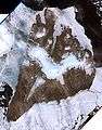
Bolshevik Island image (Landsat-7 1999-07-29)
-
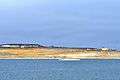
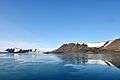
Southern coast of
Bolshevik Island:
Antsev Point (78°11’N, 103°7’E) -
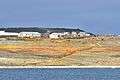
Southern coast of
Bolshevik Island:
Solnechnaya Bay (78°11’N, 103°7’E) -
Southern coast of
Bolshevik Island:
Solnechnaya Bay (78°11’N, 103°7’E) -
Southern coast of
Bolshevik Island:
Solnechnaya Bay (78°11’N, 103°7’E) -
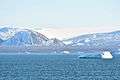
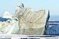
Bolshevik Island:
Akhmatowa Fiord (79°30‘N, 103°12‘E) -
Bolshevik Island:
Akhmatowa Fiord (79°30‘N, 103°12‘E) -
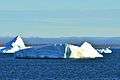
Bolshevik Island:
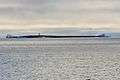
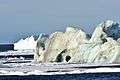
Mikojana Bay at one of the world’s most spectacular iceberg roads -
Bolshevik Island:
Mikojana Bay (79°22‘N, 102°E) -

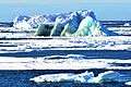
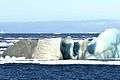
Northeast coast of Bolshevik Island:
iceberg road (79°28‘N, 103°E) -
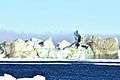
Northeast coast of Bolshevik Island:
iceberg road (79°28‘N, 103°E) -
-
-
-
Weather conditions
The weather on the island is extremely cold; the annual average temperature is −16 °C (3 °F).[5]
See also
References
- 1 2 3 McCoy, John F. (ed.) (2002) Geo-Data: The World Geographical Encyclopedia Thomson-Gale
- ↑ Barr, William (1975). "Severnaya Zemlya: the last major discovery". Geographical Journal. 141 (1): 59–71. JSTOR 1796946.
- ↑ "Mys Peschanyy". Mapcarta. Retrieved 27 November 2016.
- ↑ "Mys Neupokoyeva". Mapcarta. Retrieved 29 November 2016.
- 1 2 ""Severnaya Zemlya"". Archived from the original on 2010-12-23. Retrieved 2009-03-14. (translated as "North Land). Oceandots.com. Accessed May 2011
External links
 Media related to Bolshevik Island at Wikimedia Commons