Attack on Orleans
| Attack on Orleans | |||||||
|---|---|---|---|---|---|---|---|
| Part of the U-boat Campaign of World War I | |||||||
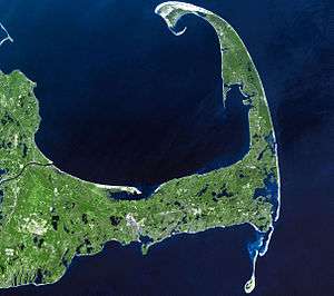
 A view of Cape Cod, the location of Orleans, from space. | |||||||
| |||||||
| Belligerents | |||||||
|
|
| ||||||
| Commanders and leaders | |||||||
| unknown |
| ||||||
| Strength | |||||||
|
Sea: 1 tugboat 4 barges Air: 9 Curtiss HS seaplanes | 1 submarine | ||||||
| Casualties and losses | |||||||
|
1 tugboat sunk 4 barges sunk, no human casualties | none | ||||||
The Attack on Orleans was a naval and air action during World War I which took place on 21 July 1918. A German U-boat opened fire on the American town of Orleans, Massachusetts, and several merchant vessels nearby. A tugboat was sunk, but shells fired in the direction of the town landed harmlessly in a marsh and on a beach.
On the morning of 21 July 1918 – during the last year of the First World War – the German submarine U-156, Captained by Richard Feldt, surfaced three miles off the coast of Cape Cod, Massachusetts, and began to shell the tugboat "Perth Amboy" and the four barges in her tow. A handful of the shells fired by the U-boat’s two deck guns struck Nauset Beach, giving the town of Orleans the distinction of being the first, and only, spot in the United States to receive fire from the enemy during the First World War.
Coming to Cape Cod’s defense was the United States Life-Saving Service and the fledgling air arm of the United States Navy. The lifesavers, who were based at Station No. 40, launched a surfboat under heavy enemy shellfire and rowed in the direction of the thirty-two sailors trapped aboard the tug and barges. Meanwhile, HS-1L flying boats and R-9 seaplanes were dispatched from the Chatham Naval Air Station and dive-bombed the enemy raider with payloads of TNT. It was the first time in history that American aviators engaged an enemy vessel in the western Atlantic. Local history reports that one citizen of Orleans armed himself with a double-barreled shotgun and fired back at the U-boat from the shore.
Today, a sign celebrates the historic engagement above the beach. It reads:
"Three miles offshore, in the direction of the arrow, was the scene of attack of a German submarine on a tug and barges July 21, 1918. Several shells struck the beach. This is the only section of the United States’ coast shelled by the enemy during World War I." [1]
Aftermath
U-156 got away and headed north, where it continued to attack other allied ships. Back in Orleans, a few shells and craters were found on shore; some also were found in the nearby marsh. The area sustained minor damage. The psychological effects on the population of Orleans were immediate as people began reporting the hearing of naval battles off the coast.
Others talked about the supposed "mother ship" for U-156. Newspapers dubbed the engagement as the "Battle of Orleans" and offered a reward for the discovery of submarine supply bases in the Bay of Fundy. Towns also banned lights for fear that German spies would use them to signal U-boats. The attack on Orleans was the only Central Powers raid mounted against the United States mainland during World War I.
It was also the first time the Continental United States was shelled by a foreign power's artillery since the Siege of Fort Texas in 1846. There were no fatalities.[2] The Continental U.S. would be shelled again twice in 1942 by Japanese submarines during the Pacific War. These two engagements are known as the Bombardment of Fort Stevens along the northwest Pacific coast of Oregon, and the Bombardment of Ellwood near Santa Barbara, California.
Notes
References
- Gibson, R.H.; Maurice Prendergast (2002). The German Submarine War 1914–1918. Periscope Publishing. ISBN 1-904381-08-1.
- Sheard, Bradley (1997). Lost Voyages: Two Centuries of Shipwrecks in the Approaches to New York. Aqua Quest Publications. ISBN 1-881652-17-3.
External links
- Helgason, Guðmundur. "WWI U-boats: U 156". German and Austrian U-boats of World War I - Kaiserliche Marine - Uboat.net.
- The U-Boat That Threatened America
Coordinates: 41°47′23″N 69°59′25″W / 41.78972°N 69.99028°W