Bonaventure River
| Bonaventure River | |
| Rivière Bonaventure | |
 Mouth of the Bonaventure | |
| Country | Canada |
|---|---|
| Province | Quebec |
| Region | Gaspésie–Îles-de-la-Madeleine |
| Tributaries | |
| - left | Hall River |
| - right | West Bonaventure River |
| Source | Chic-Choc Mountains |
| - location | Mont-Albert, Quebec |
| - elevation | 600 m (1,969 ft) |
| - coordinates | 48°53′00″N 65°32′30″W / 48.88333°N 65.54167°W |
| Mouth | Chaleur Bay |
| - location | Bonaventure, Quebec |
| - elevation | 0 m (0 ft) |
| - coordinates | 48°02′00″N 65°29′00″W / 48.03333°N 65.48333°WCoordinates: 48°02′00″N 65°29′00″W / 48.03333°N 65.48333°W |
| Length | 115 km (71 mi) [1] |
The Bonaventure River is a river in the Gaspé Peninsula of Quebec, Canada. It rises in the Chic-Choc Mountains and flows south to empty into Baie des Chaleurs near the town of Bonaventure, Quebec. The river is about 115 km (71 mi) long.[1]
The indigenous Mi'kmaq called the river Wagamet, meaning "clear water".[2] The river is still noted for its clear, cold water, making it well known as a great place for Atlantic Salmon fishing and recreational canoeing.
The origin of the river's name is uncertain. It may come from the French bonne aventure (meaning "good fortune"); or named in honour of Simon-Pierre Denys de Bonaventure; or named after the ship Bonaventure of Lord La Court de Pré-Ravillon et de Granpré who entered the Gulf of Saint Lawrence in 1591. In any case, this name was already in use in 1697 when Governor Louis de Buade de Frontenac and Superintendent Jean Bochart de Champigny granted both sides of the river as the Seignory of the Bonavanture [sic] River to Charles-Henry de La Croix.[1][3]
 Bonaventure River circa 1898
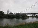 Footbridge over the Bonaventure
See also
References
- 1 2 3 "Rivière Bonaventure" (in French). Commission de toponymie du Québec. Retrieved 2012-01-03.
- ↑ Rand, Silas Tertius (1875-01-01). A First Reading Book in the Micmac Language: Comprising the Micmac Numerals, and the Names of the Different Kinds of Beasts, Birds, Fishes, Trees, &c. of the Maritime Provinces of Canada. Also, Some of the Indian Names of Places, and Many Familiar Words and Phrases, Translated Literally Into English. Nova Scotia Printing Company.
- ↑ "Bonaventure (Ville)" (in French). Commission de toponymie du Québec. Retrieved 2012-01-03.