Bonita Canyon
| Bonita Canyon | |
|---|---|
|
Bonita Canyon, facing east from the Bonita Creek picnic area. | |
 Bonita Canyon Location in the state of Arizona | |
| Location | Chiricahua Mountains, Arizona, USA |
| Floor elevation | 5360 ft[1] |
| Geography | |
| Coordinates | 32°00′29.70″N 109°21′22.16″W / 32.0082500°N 109.3561556°WCoordinates: 32°00′29.70″N 109°21′22.16″W / 32.0082500°N 109.3561556°W |
| Topo map | Cochise Head, AZ |
| Watercourses | Bonita Creek |

Bonita Canyon is a box canyon on the western slope of the Chiricahua Mountains in southeastern Arizona, which lies at 5360 feet in elevation and opens in a southwesterly direction into the Sulphur Springs Valley.[2]
The canyon walls are capped with outcroppings of volcanic tuff and separated by a narrow valley about a quarter of a mile wide. Bonita Creek flows west through the northern edge of the valley, along the northern wall of the canyon. The valley is carpeted with a variety of wild grasses and forested with oak and Arizona cypress. Animal life includes mountain lions, bobcats, black bear, mule deer, various bird and reptile species, and much more. Jaguars have also been spotted in the canyon.[2]
Bonita Canyon is now part of the Chiricahua National Monument and is also home to the Faraway Ranch Historic District, as well as a public campground. The headquarters for the Chiricahua National Monument is located just outside Bonita Canyon in the adjoining Madrone Canyon, near the Faraway Ranch.[2][3]
-
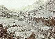
Neil Erickson relaxing on top of a rock formation in Bonita Canyon.
-
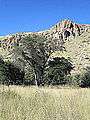
Oak woodland
-
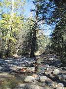
Bonita Creek
See also
References
- ↑ "Bonita Canyon, AZ at Topoquest". Retrieved 2014-12-12.
- 1 2 3 "National Register of Historic Places Inventory -- Nomination Form: Faraway Ranch Historic District" (PDF). National Park Service. Retrieved 2014-12-12.
- ↑ "Bonita Canyon Campground: Chiricahua National Monument (U.S. National Park Service)". National Park Service. Retrieved 2014-12-12.