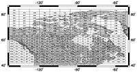
Borden System

The Borden System is an archaeological numbering system used throughout Canada and by the Canadian Museum System to track archaeological sites and the artefacts that come from them.
It was created by Charles Edward Borden with the help of Wilson Duff in 1952 at the University of British Columbia. [1]
How it Works
AaBb-11:1234
A is the Major South-North Locator - Each block represents 2 degrees of Latitude from south to north (A - U)
a is the Minor South-North Locator - Each block represents 10 minutes of Latitude from south to north (a - l)
B is the Major East-West Locator - Each block represents 4 degrees of Longitude from east to west (A - W)
(north of 62 degrees each major block represents 8 degrees of longitude)
b is the Minor East-West Locator - Each block represents 10 minutes of Longitude from east to west (a - x)
(north of 62 degrees each minor block represents 20 minutes of longitude)
Therefore, a full designation: AaBb-16 represents a roughly 16 km x 16 km area and the 16th site found within that area.
Since the number that follows is the number of the site within an area, assigned when the site is discovered, the whole number really only narrows the area to approximately a 16 km square. But it allows archaeologists to designate a site and to label every artefact from the site.
The number after the colon is the artefact number: e.g., AaBb-16:0123
Because the distance between lines of longitude get smaller with increasing latitude, the Borden System changes at 64 degrees north latitude, from a width of 4 degrees of longitude to a width of 8 degrees in order to keep the area within each designate roughly the same.
References
- ↑ Borden, Charles E.; Duff, Wilson (1952). "A Uniform Site Designation Scheme for Canada". Anthropology in British Columbia. 3: 44–48.
External links
- "Archaeology Survey of Canada: The Borden System of Site Identification". Oracles. Archived from the original on 30 September 2007. Retrieved 2007-08-17.