Branscomb Peak
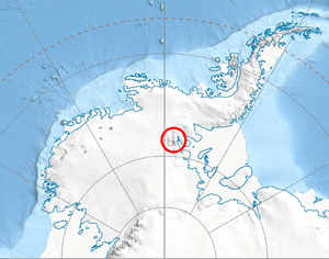
Branscomb Peak is a small snowy prominence of elevation 4,520 metres (14,830 ft), the highest point of the ridge that forms the top of the main west face of Vinson Massif in the Sentinel Range of the Ellsworth Mountains, Antarctica. It overlooks Jacobsen Valley to the northeast, Goodge Col to the north-northeast, the upper section of Branscomb Glacier to the west, and Roché Glacier to the south.
The peak was named by US-ACAN in 2006 in association with adjacent Branscomb Glacier.
Location
Branscomb Peak is located at 78°30′57″S 85°41′44″W / 78.51583°S 85.69556°WCoordinates: 78°30′57″S 85°41′44″W / 78.51583°S 85.69556°W, which is 1.27 miles (2.04 km) northwest of Mount Vinson, 2.29 miles (3.69 km) north-northwest of Silverstein Peak, 3.68 miles (5.92 km) east-southeast of Knutzen Peak and 3.74 miles (6.02 km) south of Mount Shinn. US mapping in 1961, updated in 1988.
Maps
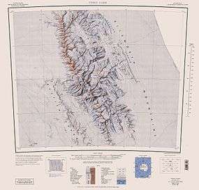
- Vinson Massif. Scale 1:250 000 topographic map. Reston, Virginia: US Geological Survey, 1988.
- Antarctic Digital Database (ADD). Scale 1:250000 topographic map of Antarctica. Scientific Committee on Antarctic Research (SCAR), 1993–2016.
References
- Branscomb Peak. SCAR Composite Gazetteer of Antarctica.
![]() This article incorporates public domain material from the United States Geological Survey document "Branscomb Peak" (content from the Geographic Names Information System).
This article incorporates public domain material from the United States Geological Survey document "Branscomb Peak" (content from the Geographic Names Information System).