Brectouville
| Brectouville | |
|---|---|
|
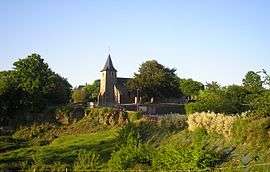
The church of Saint-Pierre | |
 Brectouville | |
|
Location within Normandy region  Brectouville | |
| Coordinates: 49°01′22″N 1°01′16″W / 49.0228°N 1.0211°WCoordinates: 49°01′22″N 1°01′16″W / 49.0228°N 1.0211°W | |
| Country | France |
| Region | Normandy |
| Department | Manche |
| Arrondissement | Saint-Lô |
| Canton | Condé-sur-Vire |
| Intercommunality | Saint-Lô Agglo |
| Government | |
| • Mayor (2008–2014) | Philippe Compère |
| Area1 | 3.74 km2 (1.44 sq mi) |
| Population (2009)2 | 159 |
| • Density | 43/km2 (110/sq mi) |
| Time zone | CET (UTC+1) |
| • Summer (DST) | CEST (UTC+2) |
| INSEE/Postal code | 50075 / 50160 |
| Elevation |
29–137 m (95–449 ft) (avg. 85 m or 279 ft) |
|
1 French Land Register data, which excludes lakes, ponds, glaciers > 1 km² (0.386 sq mi or 247 acres) and river estuaries. 2 Population without double counting: residents of multiple communes (e.g., students and military personnel) only counted once. | |
Brectouville is a former commune in the Manche department in Normandy in northwestern France. On 1 January 2016, it was merged into the new commune of Torigny-les-Villes.[1]
Population
| Historical population | ||
|---|---|---|
| Year | Pop. | ±% |
| 1793 | 194 | — |
| 1800 | 192 | −1.0% |
| 1806 | 212 | +10.4% |
| 1821 | 334 | +57.5% |
| 1831 | 230 | −31.1% |
| 1836 | 240 | +4.3% |
| 1841 | 242 | +0.8% |
| 1846 | 259 | +7.0% |
| 1851 | 233 | −10.0% |
| 1856 | 212 | −9.0% |
| 1861 | 174 | −17.9% |
| 1866 | 166 | −4.6% |
| 1872 | 167 | +0.6% |
| 1876 | 155 | −7.2% |
| 1881 | 153 | −1.3% |
| 1886 | 161 | +5.2% |
| 1891 | 178 | +10.6% |
| 1896 | 177 | −0.6% |
| 1901 | 146 | −17.5% |
| 1906 | 163 | +11.6% |
| 1911 | 157 | −3.7% |
| 1921 | 124 | −21.0% |
| 1926 | 135 | +8.9% |
| 1931 | 126 | −6.7% |
| 1936 | 134 | +6.3% |
| 1946 | 137 | +2.2% |
| 1954 | 142 | +3.6% |
| 1962 | 123 | −13.4% |
| 1968 | 125 | +1.6% |
| 1975 | 122 | −2.4% |
| 1982 | 149 | +22.1% |
| 1990 | 169 | +13.4% |
| 1999 | 157 | −7.1% |
| 2009 | 159 | +1.3% |
See also
References
- ↑ Arrêté préfectoral 28 September 2015 (French)
| Wikimedia Commons has media related to Brectouville. |
This article is issued from Wikipedia - version of the 8/16/2016. The text is available under the Creative Commons Attribution/Share Alike but additional terms may apply for the media files.