Breiter Graben
| Breiter Graben | |
|---|---|
|
Breiter Graben (top left) joining Struga near Mulkwitz | |
| Other name(s) | Flutgraben |
| Country | Germany |
| Basin | |
| Main source |
Nochtener Weg, Mühlrose 51°29′04″N 14°31′38″E / 51.48444°N 14.52722°E |
| River mouth |
east of bridge of state road 130, Mulkwitz 51°30′34″N 14°29′30″E / 51.50944°N 14.49167°ECoordinates: 51°30′34″N 14°29′30″E / 51.50944°N 14.49167°E |
| Progression | Struga – Spree – Havel – Elbe – North Sea |
| Physical characteristics | |
| Length | 4.4 km |
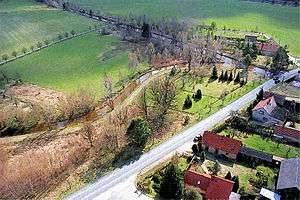
Breiter Graben is a canal in Landkreis Görlitz, Saxony, Germany. It is also known as Flutgraben and runs between the north-western edge of the lignite open-cast mine Nochten and the village of Mulkwitz where it joins the river Struga, a tributary of the river Spree. On its course, it passes north of the village Mühlrose. Its acidic, iron-rich water, originating from an open-cast mine, heavily pollutes Struga river.[1]
See also
References
- ↑ L. Küchler, S. Harnapp (2004). Gewässergütebericht 2003 - Biologische Befunde der Gewässergüte sächsischer Fließgewässer mit Gewässergütekarte (PDF). Materialien zur Wasserwirtschaft. Sächsisches Landesamt für Umwelt und Geologie (LfUG), Dresden. p. 48.
This article is issued from Wikipedia - version of the 8/31/2016. The text is available under the Creative Commons Attribution/Share Alike but additional terms may apply for the media files.