Bridlewood, Ottawa
Bridlewood is a neighbourhood in Kanata South Ward in the western part of Ottawa, Ontario, Canada. Bridlewood was part of the Township of Nepean until 1978, and then part of the City of Kanata until 2001, when that city amalgamated with the City of Ottawa.
Location
Bridlewood is located east of Eagleson Road, south and west of the National Capital Commission Greenbelt, and north of Hope Side Road. This community is located in the southeast part of the former city of Kanata and is 12 KM from the boundary of pre-amalgamation Ottawa proper.
History
Bridlewood began to develop as a residential area in the 1980s in the northern part of the community. Previous to that, the land was used for agricultural purposes. William Teron spurred development with his purchase of agricultural land in order to create a model community that subsequently evolved into Kanata.[1]
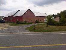
Most of the land that became Bridlewood was originally part of the Deevy farm, in the Township of Nepean. On January 1, 1978, Bridlewood was amalgamated into the new City of Kanata. The farmhouse and barn remained in the centre of the community just off Equestrian Drive until it was demolished in 2013.
In the early 1970s, Ontario Hydro installed a hydro line corridor through what would become the community, and in 1989 the voltage of the hydro lines was increased from a single 230 kV line to two (i.e., twin) towers with 500 kV lines. The Bridlewood Residents Hydro Line Committee (now defunct) opposed this change, citing concerns for children's health when exposed to electromagnetic radiation. The BRHLC struggle received national media attention, including by CTV's W5 and CBC's The Journal.[2]
According to the Canada 2006 Census, there were 19,167 people living in Bridlewood. The 2011 Census reported 21,247 people living in Bridlewood.
Community
The Bridlewood Community Association (BCA) serves not only Bridlewood but the adjacent community of Emerald Meadows. The BCA deals with various community matters including sports, outdoor hockey rinks, garage sales, safety and security, business networking, traffic volume concerns, and developer and zoning activity.[3]
Bridlewood is served by local councillor Allan Hubley as it is part of the Kanata South Ward.
For several years, the neighbourhood has been plagued by a significant traffic congestion problem, particularly on the main street, Stonehaven Drive, which bore the vast majority of the traffic getting out onto Eagleson Road to the west and Richmond Road to the east. Due to the presence of four schools along Stonehaven Drive, that Richmond Road is two-lanes wide (though planned to be widened to four lanes in the future), the lack of other streets exiting the community, the street layouts which consists of numerous crescent or P-shaped streets and connectors all funneling onto Stonehaven, infrequent transit service (OC Transpo Routes 61, 66 (both express routes), 164 (a peak-only route on Hope Side Road) and local route 168 been the main routes of the community) as well as a higher population density (as there are numerous townhouses, row houses and condos), commuters often took as much as 25 minutes to exit the community during morning rush hour.[4]
Sports
Sports participation is significant in Bridlewood. The BCA estimates participance of over 800 children for the 2007 soccer program. Bridlewood is a community participant in the True Sport movement,[5] which is a Canadian program espousing goals of ensuring positive and meaningful experiences for sport participants.
Schools
There are six elementary schools in this area:
Primary schools
- W.O. Mitchell Elementary School
- Bridlewood Community Elementary School
- Roch Carrier Elementary School
Catholic schools
- St. James Catholic School
- St. Anne Catholic School
- Elizabeth Bruyere Catholic School
New public French language elementary school "École élémentaire publique Kanata-Sud" was opened in September 2010.[6]
Community shopping plazas
There are three strip malls in this community:
Stonehaven Plaza
Located at 701 Eagleson Road.
- Optometrist
- Bridlewood Animal Hospital
- Big Bone BBQ
- Hair Tech (Hair Salon) Formerly known as Hair Tech 2000
- Kanata Music Academy
- Scotiabank
Eagleson Plaza
Located at 700 Eagleson Rd.
- Beer Store
- Bridlewood Chiropractic and Massage Therapy
- Bridlewood Home Hardware
- Domino's Pizza
- First Choice Haircutters
- Goodlife Fitness (opening September 2013)
- Harvey's
- Heavenly Spa
- Kanata Dental Centre
- Rogers Plus
- Shoppers Drug Mart
- Starbucks Coffee
- Subway
- TD Canada Trust
- Wild Wing
Bridgestone Plaza
- Black Belt Excellence Martial Arts
- Bridlewood Medical Centre
- Mac's Milk
- Gabriel Pizza and Italian Restaurant
- The Works (Gourmet Burger Bistro)
- Hurley's
- Tiny Hoppers
- Snap Fitness
Notable residents
References
- ↑ Ottawa Living reference
- ↑ Bridlewood Electromagnetic Fields (EMFs) InformationService
- ↑ Bridlewood website
- ↑ "Archived copy". Archived from the original on 2015-02-22. Retrieved 2014-12-21.
- ↑ True Sport website
- ↑ http://www.emckanata.ca/20091120/News/New+French+school+breaks+ground+in+Kanata[]
External links
- Bridlewood Community Association, accessed 12 November 2006
45°17′N 75°51′W / 45.283°N 75.850°W
 |
Greenbelt | | ||
| Glen Cairn | |
Greenbelt | ||
| ||||
| | ||||
| Emerald Meadows |