Brislington Brook
| Brislington Brook | |
| stream | |
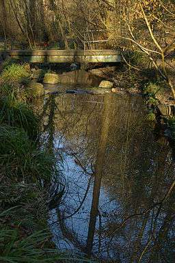 Brislington Brook in St Annes Wood | |
| Country | England |
|---|---|
| Region | West Country |
| District | Bristol |
| Source | Maes Knoll |
| - location | Whitchurch, Bristol, England |
| - elevation | 476 ft (145 m) |
| - coordinates | GB-ENG 51°23′43″N 2°34′22″W / 51.3952°N 2.5729°W |
| Mouth | Bristol Avon |
| - location | St Annes, Bristol, England |
| - elevation | 33 ft (10 m) |
| - coordinates | GB-ENG 51°27′14″N 2°32′49″W / 51.4539°N 2.5469°WCoordinates: GB-ENG 51°27′14″N 2°32′49″W / 51.4539°N 2.5469°W |
| Length | 5 mi (8 km), northerly |
| Basin | 4.6 sq mi (12 km2) |
| River system | Bristol Avon |
 Diagrammatic map of the Brislington Brook within Bristol
| |
Brislington Brook is a short, 5 miles (8.0 km) long tributary of the Bristol Avon, rising on the northern slopes of Maes Knoll on the southern boundary of the city of Bristol, England. The stream has been badly affected by pollution but improvements have been made in the latter part of the twentieth century, and some wildlife is supported. St Anne's Well near the northern end of the brook was a major pilgrimage site for Christians in the Middle Ages.
Course
Brislington Brook rises in twin tributaries fed by springs on the northern slopes of Maes Knoll, at the eastern end of Dundry Hill, just north of the boundary between Somerset and Bristol. One branch flows culverted through the Bamfield estate and then runs on the surface alongside Airport Road.[1]
The other briefly enters Bath and North East Somerset, then enters a shallow valley, passing underneath Saltwell Viaduct, which carries the A37 Wells Road. The brook then re-enters Bristol, passing between Hengrove and Flowers Hill, on into Brislington, being met by a small unnamed tributary on the right bank just before it passes underneath the A4174 road, where it joins the western tributary at West Town Lane. Brislington Brook then turns in a northeast direction, passing underneath the A4 Bath Road and flowing down into Nightingale Valley in Broomhill, passing under a restored packhorse bridge.[1] Near here, a side weir carries excess water in times of heavy rainfall into a tunnel which discharges into the Avon opposite Conham.[2]
Brislington Brook itself then resumes its northerly course and is augmented by water from St Anne's Spring before running through industrial estates in St Annes Park before joining the Avon in a culvert at the site of the former St Annes Board Mills.
History
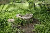
St Anne's Spring was in medieval times a site of pilgrimage to venerate Saint Anne, mother of the Virgin Mary. A ferry from the northern (Gloucestershire) bank, which conveyed pilgrims across the Avon, was recorded in the Domesday Book in 1087. In 1485, Henry VII visited St Anne in the Wood, a chapel erected nearby, possibly by the Barons de la Warr who held Brislington Manor.[3][4] The chapel was described by William Worcester, the noted fifteenth-century chronicler, as being 19 yards (17 m) long and 5 yards (4.6 m) wide, and containing a number of giant wax candles, some 80 feet (24 m) high, which had been donated by some of the city guilds. John Latimer, in his book Sixteenth Century Bristol, considered the height of the candles to have been exaggerated.[5] The site was described by the early Protestant reformer Hugh Latimer "as being no less famous for pilgrimage than the shrine at Walsingham." After the Dissolution of the Monasteries the chapel was pulled down and the lands let to local gentry.[6]
Natural history and hydrology
Kingfishers and eels have been identified in Nightingale Valley, which also supports a range of trees and plants. The water quality is regularly sampled by Bristol City Council. In the 1990s improvements were made by identifying and rectifying illegal sewage connections,[7] but water quality remains poor with relatively high biochemical oxygen demand and a high count of coliform bacteria.[8]
References
- 1 2 "Brislington Brook walk" (PDF). South Bristol Riverscapes. Retrieved 2009-12-07.
- ↑ Quinn, Phil (August 2009). "Wildlife Survey of Brislington Brook" (PDF). bristolrivers.com. p. 28. Retrieved 23 March 2013.
- ↑ Lovegrove, Chris (March 1986). "St Anne in the Wood, Brislington". Source Online Archive. Retrieved 2009-12-07.
- ↑ "St Ann's Well (Brislington)". The Megalithic Portal. Retrieved 2009-12-07.
- ↑ Latimer, John (1908). Sixteenth Century Bristol (in latimer-16-p5). Bristol: J. W. Arrowsmith. p. 5.
- ↑ Richardson, Rev. A. (1898). "St Anne's Chapel, Brislington". Proceedings. Somersetshire Archaeological and Natural History Society. XLIV: 188–196.
- ↑ "Bristol Living Rivers Project - Waterways Monitoring - Brislington Brook". Bristol City Council. Retrieved 2009-12-07.
- ↑ "Bristol surface water quality monitoring results". Bristol City Council. September 2010. Retrieved 16 October 2010.