Broadback River
| Broadback | |
| River | |
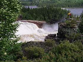 Tupatukasi Waterfall, Broadback River | |
| Country | Canada |
|---|---|
| Province | Quebec |
| Region | Jamésie |
| Source | Lac Frotet |
| - location | 95 km north of Chibougamau |
| - elevation | 380 m (1,247 ft) |
| - coordinates | 50°46′0″N 74°39′20″W / 50.76667°N 74.65556°W |
| Mouth | Rupert Bay off James Bay |
| - location | 17 km south of Waskaganish |
| - elevation | 0 m (0 ft) |
| - coordinates | 51°21′20″N 78°52′00″W / 51.35556°N 78.86667°WCoordinates: 51°21′20″N 78°52′00″W / 51.35556°N 78.86667°W |
| Length | 450 km (280 mi) [1] |
| Basin | 20,800 km2 (8,000 sq mi) [1] |
| Discharge | |
| - average | 350 m3/s (12,360 cu ft/s) [1] |
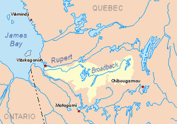 Broadback River basin in yellow
| |
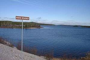
The Broadback River (French: Rivière Broadback) is a river in northern Quebec, Canada. It drains into Rupert Bay (a smaller bay at the south end of James Bay), just south of the Rupert River and Cree community Waskaganish. The major lake on the river's course is Lac Evans.
The Broadback, together with the Nottaway and Rupert Rivers, was initially considered to be dammed and diverted as part of the James Bay Project. But in 1972 hydro-electric development began on the more northerly La Grande and Eastmain Rivers, and the NBR Project was shelved. With the decision to divert the Rupert River to the La Grande, it is not likely that the Broadback will be developed in the foreseeable future.
River is a popular canoe-tripping destination.[2]
Tributaries
Since the Broadback River flows relatively close to the northern edge of its basin, most of its major tributaries are left tributaries. Major tributaries in downstream order include:
Tributaries upper than Evans Lake
- Châtillon River
- Assinica River
- Coigne River (right tributary)
- Nipukatasi River
- Salamandre River
Tributaries lower than Evans Lake
- Ouasouagami River
- Colomb River
- Kaminahikuschit River
- Natouacamisie River
- Machisipi River
- Lepallier River
References
- 1 2 3 Atlas of Canada Archived February 2, 2007, at the Wayback Machine.
- ↑ Lester Kovac. "Broadback 2005".