Brough with St Giles
Brough with St. Giles is a village and a civil parish in the Richmondshire district of North Yorkshire, England. The civil parish also includes the settlements of Catterick Bridge and Walkerville, and Catterick Racecourse and the site of the Roman town of Cataractonium. According to the 2001 Census the parish had a population of 338, increasing to 801 at the 2011 Census.[1]
Brough was known as Burgh until the 17th century.[2] It was historically a township in the ancient parish of Catterick in the North Riding of Yorkshire. It became a separate civil parish in 1866. In 1974 it was transferred to the new county of North Yorkshire.
St Giles is now a single farm in the north of the parish. Near the modern farm is the site of the medieval hospital of St Giles, a Scheduled Ancient Monument excavated in 1988-1990.[3]
Brough Hall is a Grade I listed country house which has now been converted to apartments. It was originally built in the 15th century but has been altered and extended several times since then. Originally owned by the de Burgh family, from c.1575 it belonged to the Lawsons.[4]
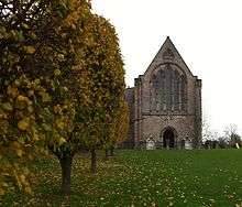
The former Roman Catholic church of St Paulinus in the grounds of Brough Hall was designed in 1837 by Ignatius Bonomi for the recusant William Lawson and is a Grade II* listed building.[5]
References
- ↑ "Civil Parish population 2011". Retrieved 8 August 2015.
- ↑ William Page, ed. (1914). "Parishes: Catterick". Victoria County History. A History of the County of York North Riding: Volume 1. pp. 301–313. Retrieved 14 May 2016.
- ↑ "St Giles medieval hospital, post-medieval farmstead and Iron Age occupation site immediately north of St Giles Farm". Historic England. Retrieved 14 May 2016.
- ↑ "Brough Hall, Brough with St Giles". British Listed Buildings. Retrieved 5 December 2013.
- ↑ "Name: CHURCH OF ST PAULINUS, PRESBYTERY AND ATTACHED OUTBUILDINGS. List entry Number: 1179809". English Heritage. Retrieved 5 December 2013.
Coordinates: 54°22′55″N 1°39′58″W / 54.382°N 1.666°W