Buena Suerte, Palawan
| Barangay Buena Suerte Buena Suerte | |
|---|---|
| Barangay | |
|
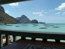
View of Aplaya, with the famous marble cliffs and the El Nido Port Zone at the background | |
| Country | Philippines |
| Region | Region IV-B (MIMAROPA) |
| Province | Palawan |
| District | 1st District |
| Municipality | El Nido |
| Government | |
| • Type | Local Government Unit (LGU) |
| Population (2007) | |
| • Total | 2,209 |
| Time zone | PST (UTC+8) |
| Postal Code | 5313 |
| Area code(s) | 48 |

Buena Suerte (officially the Barangay Buena Suerte), or more known as Zone II, is one of the eighteen barangays comprising the Municipality of El Nido in the province of Palawan in the Philippines.[1] Its name literally means "Good Luck" in Spanish.
During the Spanish era, Cabigsing, the westernmost purok of the barangay, was the center of the town. It was then known as the Inventario.
Geography
Buena Suerte, one of the four Población barangays, sits on the western section of the town proper, occupying the areas from the famous limestone and marble cliffs called taraw that act as a backdrop and run from the southern to its westernmost sections, the Lapus-Lapus Trail that leads to the beaches of Ipil Point and Siete Commando opposite the surrounding mountain walls, and to the St. Francis of Assissi Parish Church that serves as the main office of the Parish of El Nido. It is bordered by Masagana on the east and Maligaya on the southeast. A creek, draining from Maligaya, transverses in the south and to the sea in the northwest. Off the coast of Buena Suerte lies Cadlao Island, the largest among the 45 islands in the Bacuit Bay. Its highest peak towers up to 640 meters above sea level, and is considered as El Nido's tallest mountain. The island has several pockets of white sand beaches, hidden lagoons and nature trails that lead to lush tropical rainforest. One of these nature trails leads to the charming saltwater Makaamo Lagoon, which is surrounded by mangroves that attract a proliferation of birds.[2] Sabang Beach, one of its many beaches, was one of the settings for the Scandinavian show Robinson Expedisjonen, the predecessor to Survivor.
Government
Buena Suerte is composed of four puroks or sitios namely, Aplaya, the beachfront area; Putting Bato (White Rock), the cliffside area; Cabigsing, the port area, and Cadlao, the largest island off the coast of the municipality.
Like all other barangays in the country, it is governed from the Barangay Hall by a Barangay Captain, an elected official entitled for three-year term, who is aided by the Sangguniang Barangay members (barangay kagawads or counselors), also elected. In 2005, it has a budgetary allocation of PHP 681,365 from the Philippine government.[3]
Demographics

Population
Buena Suerte, one of the most densely populated area in the entire municipality, ranks only third to Bucana and Teneguiban in terms of the total number of constituents. As of August 1, 2007, it has a population of 2,209. The barangay has a heavy presence of migrants from other parts of the Philippines, and it is also home to a number of foreigners who intermarried with the local inhabitants.
Livelihood
Being a coastal area, the main livelihood is fishing and tourism. Seafood is a local speciality, in fact, many fishes are exported to Manila, and to other Southeast Asian countries. Commercial and tourist establishments also abound the area. Bay View Inn (also known as El Nido Sands Inn),[4] the oldest tourist inn, can be found here.
Religion
Buena Suerte is predominantly Catholic as the rest of El Nido, although there are sizable number of people who constitute other Christian denominations, such as Baptist, Iglesia Ni Kristo, among others.
Transportation
Seaport
Located in Cabigsing, El Nido Port Zone, serves a number of cargo and passenger ships from Coron and Manila. Since March 7, 2005, the port zone has been managed and supervised by the Philippine Ports Authority.[5] Pump boats and speedboats also dock at the side of the port.
In 2009, plans of establishing a 51,440 square meter-Roll On Roll Off (Roro) port in Buena Suerte was stalled after facing strong opposition from the Department of Tourism and local communities. Citing that the project would not only damage the ecosystem, critics of the port project also found out that it would go against the municipality's Comprehensive Land and Water Use Plan, which stated that the area is limited to "low density and nature-based" tourism activities.[6]
Road systems and bridges
Most roads and streets in Buena Suerte are made of concrete materials and rolled gravel. The main roads are Calle Real near Putting Bato (White Rock) and Sirena Street in Aplaya. Tricycles and motorcycles are the most popular types of transportation to go around the barangay because some of the streets here are too narrow for jeepneys and private vehicles to pass by. In addition, makeshift and wooden bridges are common in estuarine parts of Putting Bato and Cabigsing that are lying on a nearby creek or situated in what used to be mangrove forests.
References
- ↑ List of barangays in the Philippines Archived April 28, 2010, at the Wayback Machine..
- ↑ Beaches of El Nido and Bacuit Bay.
- ↑ Department of Budget and Management Archived July 18, 2011, at the Wayback Machine. Accessed August 26, 2008.
- ↑ El Nido Tourism Accommodation List.
- ↑ Executive Order No. 412 Archived September 5, 2008, at the Wayback Machine.. Accessed August 25, 2008.
- ↑ DoT opposes Roro port in El Nido Archived August 26, 2009, at the Wayback Machine.. The Philippine Daily Inquirer. August 23, 2009. Accessed March 29, 2010.
External links
Coordinates: 11°50′N 122°05′E / 11.833°N 122.083°E