Buffalo Creek (Guyandotte River)
| Buffalo Creek | |
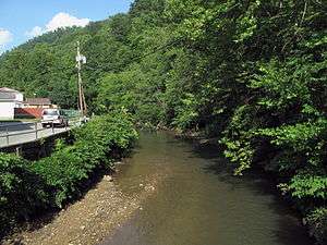 Buffalo Creek in Man in 2010 | |
| Country | United States |
|---|---|
| State | West Virginia |
| County | Logan County |
| Source | |
| - location | east of Saunders |
| - elevation | 2,602 ft (793 m) [1] |
| - coordinates | 37°47′25″N 81°36′41″W / 37.7903875°N 81.6114994°W [2] |
| Mouth | Guyandotte River |
| - location | Man |
| - elevation | 725 ft (221 m) [2] |
| - coordinates | 37°44′29″N 81°52′39″W / 37.7414961°N 81.8776191°WCoordinates: 37°44′29″N 81°52′39″W / 37.7414961°N 81.8776191°W [2] |
| Length | 18.8 mi (30 km) |
| Basin | 45 sq mi (117 km2) |
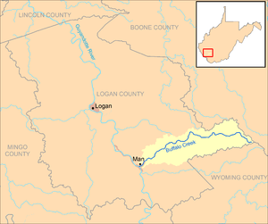 Buffalo Creek and its watershed in Logan County, West Virginia
| |
Buffalo Creek is a tributary of the Guyandotte River, 18.8 miles (30.3 km) long,[3] in southern West Virginia in the United States. Via the Guyandotte and Ohio rivers, it is part of the watershed of the Mississippi River, draining an area of 45 square miles (120 km2)[4] in the Logan Coalfield. The creek was the site of the Buffalo Creek Flood in 1972.
Buffalo Creek's entire course and drainage area are in eastern Logan County. It rises near the common boundary of Logan, Wyoming, and Boone counties and flows generally west-southwestward through the unincorporated communities of Saunders, Pardee, Lorado, Craneco, Lundale, Stowe, Crites, Latrobe, Robinette, Amherstdale, Becco, Braeholm, Accoville, Crown, and Kistler, to the town of Man, where it flows into the Guyandotte River from the northeast.[5]
According to the West Virginia Department of Environmental Protection, approximately 92% of the Buffalo Creek watershed is forested, mostly deciduous.[4]
See also
References
- ↑ Google Earth elevation for GNIS source coordinates. Retrieved on 2011-10-15.
- 1 2 3 Geographic Names Information System. "Geographic Names Information System entry for Buffalo Creek (Feature ID #1536626)". Retrieved 2011-10-15.
- ↑ United States Environmental Protection Agency. "Watershed Assessment, Tracking & Environmental Results: Assessment Summary for Reporting Year 2008, West Virginia, Upper Guyandotte Watershed". Archived from the original on 2011-10-15. Retrieved 2011-10-15.
- 1 2 West Virginia Department of Environmental Protection. "Upper Guyandotte River". Watershed Atlas Project. Archived from the original on 2005-04-05. Retrieved 2011-10-15.
- ↑ West Virginia Atlas & Gazetteer. Yarmouth, Me.: DeLorme. 1997. pp. 57–58. ISBN 0-89933-246-3.