Buffalo Pound Lake
| Buffalo Pound Lake | |
|---|---|
 | |
| Location | Saskatchewan |
| Coordinates | 50°39′N 105°30′W / 50.650°N 105.500°WCoordinates: 50°39′N 105°30′W / 50.650°N 105.500°W |
| Lake type | Prairie lake |
| Primary inflows | Qu'Appelle River |
| Primary outflows | Qu'Appelle River |
| Catchment area | 3,310 km2 (1,280 sq mi) |
| Basin countries | Canada |
| First flooded | 1939 |
| Max. length | 35 km (22 mi) |
| Max. width | 2 km (1.2 mi) |
| Surface area | 29.5 km2 (11.4 sq mi) |
| Average depth | 3 m (9.8 ft) |
| Max. depth | 5.6 m (18 ft) |
| Water volume | 0.0898 km3 (0.0215 cu mi) |
| Residence time | 1.5 years |
| Shore length1 | 72.5 km (45.0 mi) |
| Surface elevation | 509.47 m (1,671.5 ft) above sea level |
| Islands | none |
| Settlements | none |
| 1 Shore length is not a well-defined measure. | |
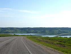
Buffalo Pound Lake is a eutrophic prairie lake in Saskatchewan, Canada, formed from glaciation about 10,000 years ago, on the Qu'Appelle River approximately 28 km north of Moose Jaw, 11 km east of Tuxford and 3 km north of Sun Valley. The lake gets its name from the method used by First Nations people to capture the bison using the natural topography as corrals or buffalo pounds. Bison once numbered more than 60 million, by 1900 they were all but extinct due to settlement. Bison were reintroduced into the area in 1972. The Qu'Appelle River was dammed by the Buffalo Pound Dam in 1939 to control fluctuating water levels. The dam is an embankment dam approximately 1400 metres long.
A fish ladder installed in 1999-2000 allows fish to migrate in and out of the lake and new gates were installed to create a better water supply downstream. The height of the dam was also raised 1 metre. The problem with fluctuating water levels wasn't solved all together until the construction of the Qu'Appelle River Dam and Gardiner Dam that created Lake Diefenbaker 100 km upstream in 1967. As a result water flow in the Qu'Appelle River now remains relatively constant. This however has flushed the lake out and allowed excessive algae growth due to the cleaner water which reduced the popularity of swimming and boating during the summer months, raised the cost of water treatment, and the lake still remains eutrophic, due to low oxygen levels and highly nutritious soil on the lake's bottom.
The lake provides drinking water for the cities of Regina, Moose Jaw, and The Mosaic Company potash mine at Belle Plaine, approximately 25% of the province's population. It is also used for recreational purposes such as camping, boating, and fishing and is home to a host of fish species including walleye, sauger, yellow perch, northern pike, cisco, mooneye, lake whitefish, white sucker, channel catfish, burbot, bigmouth buffalo, and common carp. Buffalo Pound Provincial Park is located on the southeastern shore of the lake and can be accessed by Highway 202 and Highway 301. cabins can be rented or bought along the shores of the lake.
Highway 2 crosses by causeway on the lake.
The Moose Jaw River joins the Qu'Appelle River 5 km east of the dam.
External links
- International Lake Environment Committee page on Buffalo Pound Lake including Map
- Saskatchewan Watershed Authority Page on Buffalo Pound Dam and Buffalo Pound Lake
- Fish Species of Saskatchewan
- Buffalo Pound Dam
- News at gov.sk.ca
- http://www.saskhyways.homestead.com[]
- Buffalo Pound Provincial Park