Bulgarian toponyms in Antarctica T
Coordinates: 90°S 0°W / 90°S -0°E

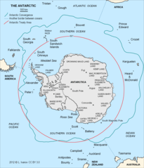
The South Polar Region.
A | B | C | D | E | F | G | H | I | J | K | L | M | N | O | P | Q | R | S | T | U | V | W | Y | Z
- Takev Point, Foyn Coast
- Talev Glacier, Graham Coast
- Tambra Island, Biscoe Islands
- Tangra Mountains, Livingston Island
- Tarakchiev Point, Davis Coast
- Taran Plateau, Brabant Island
- Targovishte Glacier, Greenwich Island
- Taridin Ridge, Oscar II Coast
- Tarnovo Ice Piedmont, Livingston Island
- Tatarchev Nunatak, Oscar II Coast
- Tatul Island, Robert Island
- Telerig Nunatak, Greenwich Island
- Telish Rock, Livingston Island
- Temenuga Island, Anvers Island
- Tepava Ridge, Oscar II Coast
- Teres Ridge, Livingston Island
- Terter Peak, Greenwich Island
- Tervel Peak, Livingston Island
- Teshel Cove, Low Island
- Teteven Glacier, Greenwich Island
- Thamyris Glacier, Anvers Island
- Ticha Peak, Livingston Island
- Tikale Peak, Oscar II Coast
- Tile Ridge, Greenwich Island
- Timok Cove, Rugged Island
- Tintyava Peak, Trinity Peninsula
- Tirizis Island, Robert Island
- Tlachene Cove, Loubet Coast
- Toledo Island, Livingston Island
- Topola Ridge, Davis Coast
- Toros Peak, Sentinel Range
- Trajan Gate, Trinity Peninsula
- Trakiya Heights, Trinity Peninsula
- Trambesh Peak, Brabant Island
- Tran Crag, Livingston Island
- Transmarisca Bay, Krogh Island
- Trave Peak, Nordenskjöld Coast
- Travnik Buttress, Oscar II Coast
- Trebishte Island, Anvers Island
- Treklyano Island, Robert Island
- Trepetlika Glacier, Danco Coast
- Treskavets Glacier, Clarence Island
- Trigrad Gap, Livingston Island
- Troyan Peak, Livingston Island
- Tryavna Peak, Livingston Island
- Tsamblak Hill, Livingston Island
- Tsarevets Buttress, Trinity Peninsula
- Tsarigrad Peak, Smith Island
- Tsepina Cove, Robert Island
- Mount Tsotsorkov, Danco Coast
- Tuida Cove, Nelson Island
- Tumba Ice Cap, Graham Land
- Tundzha Glacier, Livingston Island
- Tutrakan Peak, Livingston Island
- Tvarditsa Rocks, Greenwich Island
See also
External links
- Bulgarian Antarctic Gazetteer
- SCAR Composite Gazetteer of Antarctica
- Antarctic Digital Database (ADD). Scale 1:250000 topographic map of Antarctica with place-name search.
This article is issued from Wikipedia - version of the 6/17/2016. The text is available under the Creative Commons Attribution/Share Alike but additional terms may apply for the media files.
