Burdekin River
| Burdekin | |
| River | |
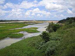 Burdekin River, 2005, taken from the Burdekin Bridge | |
| Name origin: Thomas Burdekin | |
| Country | Australia |
|---|---|
| State | Queensland |
| Regions | North Queensland, Far North Queensland |
| Tributaries | |
| - left | Running River, Fanning River, Kirk River |
| - right | Dry River (Queensland), Clarke River (Queensland), Basalt River, Broughton River (Queensland), Cape River (Queensland), Suttor River, Bowen River (Queensland), Bogie River |
| Settlements | Charters Towers, Home Hill |
| Source | Seaview Range |
| - location | near Ingham |
| - elevation | 620 m (2,034 ft) |
| - coordinates | 18°42′12″S 145°44′23″E / 18.70333°S 145.73972°E |
| Mouth | Coral Sea |
| - location | Upstart Bay |
| - elevation | 0 m (0 ft) |
| - coordinates | 19°38′49″S 147°29′14″E / 19.64694°S 147.48722°ECoordinates: 19°38′49″S 147°29′14″E / 19.64694°S 147.48722°E |
| Length | 886 km (551 mi) |
| Basin | 129,700 km2 (50,077 sq mi) |
| Discharge | |
| - average | 380 m3/s (13,420 cu ft/s) |
| - max | 40,000 m3/s (1,412,587 cu ft/s) |
| - min | 0 m3/s (0 cu ft/s) |
| Reservoir and lakes | Lake Dalrymple; Lamonds Lagoon |
| National park | Diamantina National Park |
 Location of Burdekin River mouth in Queensland
| |
| Wikimedia Commons: Burdekin River | |
| [1] | |
The Burdekin River is a river located in North and Far North Queensland, Australia. The river rises on the northern slopes of Boulder Mountain at Valley of Lagoons, part of the western slope of the Seaview Range, and flows into the Coral Sea at Upstart Bay over 200 kilometres (124 mi) to the southeast of the source, with a catchment area of approximately 130,000 square kilometres (50,000 sq mi).[2] The Burdekin River is Australia's largest river by (peak) discharge volume.[3]:5
The river was first encountered by Europeans during the expedition led by Ludwig Leichhardt in 1845 and named in honour of Thomas Burdekin, one of the sponsors of the expedition.[4]
Course and features
The Burdekin River rises on the western slopes of the Seaview Range, part of the Great Dividing Range, west of Ingham. In the river's upper catchment, from its source the river generally flows west and then south out of the Girringun National Park, part of the UNESCO Wet Tropics World Heritage Area. This area, now part of Basalt was the location of one of the earliest inland settlements in northern Australia and was known as Dalrymple.[5] The river is joined by Lucy Creek, the Running River, Star River and Keelbottom Creek, above Charters Towers. From the west in the Dry Tropics to the west of the river, the river is joined by the Clarke, Basalt and Dry rivers. South of Charters Towers, the upper catchment of the Burdekin River is joined by the Fanning River,[6] and then continues to flow south through wetlands before entering Lake Dalrymple, the reservoir created by the Burdekin Dam.
Within Lake Dalrymple, the Burdekin River is joined by the Cape, Suttor/Belyando rivers. The source of the Belyando River in central western Queensland is almost 500 kilometres (311 mi) from the mouth of the Burdekin River, and extends into the typical black-soil grassland of Central Queensland, with the Belyando draining the Drummond and Galilee Basins and flowing north for over 1,000 kilometres (620 mi).[7][8][9]
Below the dam wall, in the river's lower catchment, is northern Australia’s largest irrigation area with approximately 80,000 hectares (200,000 acres) under irrigation, predominantly for growing sugarcane. It consists of two broad regions, the earlier established delta region located on the coarse sedimentary deposits of the Burdekin River Delta, a groundwater dominated scheme, and the Burdekin Haughton Water Supply Scheme (BHWSS) - a more recently developed surface water dominated scheme on alluvial floodplains of the Burdekin River.[10] Here the Burdekin is joined by the Bowen and Bogie rivers.
The Burdekin River descends 620 metres (2,030 ft) over its 886-kilometre (551 mi) course.[1]
Four DIWA wetlands can be found along the course of the river. The first is at the Valley of Lagoons in the upper region of the catchment, the next is a Lake Dalrymple,[11] then at the junction of the Burdekin and Bowen rivers known as the Burdekin-Bowen Junction and Blue Valley Weir Aggregation[12] and the last is at the river delta which forms a 342.5 square kilometres (132 sq mi) wetland.[13]
Apart from the Murray River, the Burdekin River is economically the most important river in Australia, and has the fourth-largest watershed of any exorheic drainage system in Australia. It is also the fourth-largest river in Australia by volume of flow,[14] but is so erratic that its discharge can reach the mean discharge of the Yangtze River (after two severe cyclones in 1958) or have as many as seven months with no flow whatsoever (as in 1923). This exceedingly erratic flow is due to the extreme variability of precipitation throughout the entire basin. Annual rainfall at most gauges within the basin can range from 200 to 1,600 millimetres (7.9 to 63.0 in) depending on the monsoon and the number of cyclones that cross the coast.[15] On the coast itself, the variability is even higher: at Bowen not far from the river's mouth, the annual rainfall has ranged from 216 millimetres (9 in) in 1915 to over 2,200 millimetres (87 in) in 1950. It has the highest mean annual flow for any river adjacent to the Great Barrier Reef.[16]
History


The river was first discovered by Europeans by John Clements Wickham aboard the HMS Beagle in 1839 who named it the Wickham River. In 1849, Ludwig Leichhardt named the river after Thomas Burdekin, one of the sponsors of Leichhardt's expedition.[4] Because he was inland away from the coast he was not aware it was the same watercourse named by Wickham. The town of Wickham was established on Rita Island at the river mouth but was soon swept away during a flood in the 1860s.[4]
Pastoralists had established runs along the river during the 1860s, with some along the lower reached taken for selection in the 1880s.
In 1899, the Burdekin River Rail Bridge was built over the river about 24 km NW of Charters Towers to carry the Great Northern railway. Although replaced by a new bridge in 1964, the old bridge remains and is listed on the Queensland Heritage Register.[17]
The townships of Ayr and Brandon were established in 1882 with many sugarmills being erected. The North Coast railway between Ayr and Townsville with a bridge built over the Burdekin to Home Hill in 1913 followed by bridge for road traffic in 1930. Both were too low and often damaged during flooding and the decision was made to replace them with a higher dual level bridge known as the Silver Link. Construction commenced in 1947 and was not completed until 1957 when the bridge opened.[4]
A weir was constructed in a gorge in the Leichhardt Range for settlement farms near Calre and Dalbeg in 1953 for growing tobacco. In 1984 construction of the Burdekin Falls Dam commenced and was completed by 1987 when the dam started to fill forming Lake Dalrymple.[4]
Floods

Floods events occur on average from no floods to three per year between December and March.[16]
Heavy flooding occurred in 1875 with the Dawson, Fitzroy, Mary and Burdekin Rivers rising up to 60 feet (18 m) in a few hours. The waters washed away dwellings, fencing and livestock[18] and effects downstream included the loss of the steamer SS Gothenburg which was unable to steer effectively and ran aground on a reef at the entrance of Flinders Channel.[19]
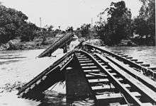
In 1917 more severe flooding occurred with the bridge at Inkerman under 11 feet (3 m) of water and the one at Ayr over 14 feet (4 m) underwater after a day of flooding.[20] Approximately one third of the Inkerman Bridge was later washed away by the floodwaters.[21]
Further flooding occurred in 1927 with waters running nearly 6 feet (2 m) over the Inkerman Bridge and 3 feet (1 m) over the Burdekin Bridge,[22] the river reached its peak at 66 feet (20 m) above summer levels at Sellheim.[23]
During the 1974 flood event associated with Cyclone Wanda, which lasted from 17 December 1973 to 23 April 1974, an estimated mass discharge peak of 25,000 tonnes (25,000 long tons; 28,000 short tons) of water per second was reached, which affected 450 kilometres (280 mi) of coastline and created a plume with widths ranging from 25 to 100 kilometres (16 to 62 mi).[16]
Water storage
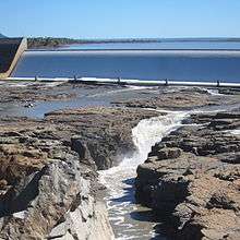
The Burdekin Falls Dam, the largest dam in Queensland was constructed west of Ayr and Home Hill and completed in 1987 to form what is also known as Lake Dalrymple.
As part of the proposed Bradfield Scheme the upper Burdekin River was to be used to feed water by gravity westwards to the upper reaches of the Flinders River.[24]
Irrigation
On the lower Burdekin floodplain an irrigation area was established in the early 1950s.[25] At first only Gorge Weir and Blue Valley Weir provided water to the scheme, until the 1970s when Eungella Dam also provided water. Water is also drawn from the Haughton River.[26] Major pump stations are located at Clare Weir feeding water to both sides of the river. An area of 2,560 square kilometres (990 sq mi) is irrigated.[26]
In the delta around Ayr and Home Hill, groundwater is used extensively to irrigate crops of sugar cane. This groundwater is recharged artificially during the extreme flood events that occasionally occur, usually due to a La Niña event. The use of groundwater in the floodplain is carefully managed so that supply can be maintained during the dry season and to prevent saltwater intrusion.[27]
Watershed
The North Coast railway line cross the river at Home Hill via a bridge constructed in 1913. At the same location the Bruce Highway traverses the river via the Burdekin Bridge. Further west, the river is crossed by the Flinders Highway.
Although on paper most of the basin of the Burdekin appears perfect for rainfed crops like cotton and maize, in fact the rainfall is so erratic that in almost every year a would-be farmer will experience either too little or too much rain for the crop to mature properly. Thus, most of the basin of the Burdekin can be used only for low-density grazing of sheep and cattle which is less likely to be damaged economically and ecologically by the extreme risks of an extraordinarily erratic climate.
The Valley of Lagoons Station was established in 1862 after the area in the upper reaches of the Burdekin was opened up by the government.[28] Initially stocked with sheep the property was later used to raise cattle. Inkerman Station was established toward the lower reaches where the town of Inkerman now stands in 1864. The area was plagued by cattle tick, so the government acquired the property in 1910 and sold-off as farmland where sugarcane was later grown.[29]
The natural vegetation away from the coast is a grassland dominated by perennial Mitchell and annual Flinders grasses, whilst near the coast there are patches of dry eucalypt forest on the typically infertile laterised soils characteristic of most of Australia.
Few mines exist along the waterway, with the notable exception of the Ben Lomond Uranium mine which is situated approximately 50 kilometres (31 mi) west of Townsville. The mine is currently dormant, but in 1981 the mine discharged toxic waste containing unacceptable levels of radioactivity,[30] when its tailing dam overflowed into a creek that feeds into the Burdekin.
Wildlife
Neosilurus mollespiculum is a species of eeltail catfish endemic to the Burdekin.[31] Many other species such as Agassiz's glassfish, Banded grunter, Barramundi, Black catfish, Eastern rainbowfish, Empire gudgeon, Freshwater longtom, Mangrove Jack, Tilapia and Yellowbelly are found throughout the catchment.[32]
See also
References
- 1 2 "Map of Burdekin River, QLD". Bonzle Digital Atlas of Australia. Retrieved 7 November 2015.
- ↑ "Flood Warning System for the Burdekin River". Bureau of Meteorology. Australian Government. June 2015. Retrieved 7 November 2015.
- ↑ Mitchell, Alan; Furnas, Miles; De’ath, Glenn; Brodie, Jon; Lewis, Steve (2006). "A report into the water quality condition of the Burdekin River and surrounds based on the AIMS end-of-catchment sampling program" (PDF). Australian Centre for Tropical Freshwater Research. James Cook University. Retrieved 7 November 2015.
- 1 2 3 4 5 "Burdekin Shire". Queensland Places. Centre for the Government of Queensland. Retrieved 10 October 2014.
- ↑ "About Dalrymple". Department of National Parks, Recreation, Sport and Racing. 27 June 2014. Retrieved 10 October 2014.
- ↑ "Social, Economic, Cultural and Environmental Values of Streams and Wetlands in the Burdekin Dry Tropics Region" (PDF). Department of National Resources, Mines and Energy. Queensland Government. July 2006. Retrieved 9 November 2015.
- ↑ "Map of Belyando River, QLD". Bonzle Digital Atlas of Australia. Retrieved 13 November 2015.
- ↑ "Map of Belyando River, QLD (2)". Bonzle Digital Atlas of Australia. Retrieved 13 November 2015.
- ↑ "Map of Belyando River (Western Branch), QLD". Bonzle Digital Atlas of Australia. Retrieved 13 November 2015.
- ↑ Petheram, C.; Tickell, S.; O’Gara, F.; Bristow, K. L.; Smith, A.; Jolly, P. (2008). "Analysis of the Lower Burdekin, Ord and Katherine-Douglas-Daly Irrigation Areas" (abstract). Cooperative Research Centre for Irrigation Futures. Retrieved 9 November 2015.
- ↑ "Lake Dalrymple – QLD006". Directory of Important Wetlands in Australia. Australian Government. 2012. Retrieved 12 October 2014.
- ↑ "Burdekin-Bowen Junction and Blue Valley Weir Aggregation – QLD205". Directory of Important Wetlands in Australia. Australian Government. 2012. Retrieved 12 October 2014.
- ↑ "Burdekin Delta DIWA nationally important wetland". Department of Environment and Heritage Protection, Queensland. 2014. Retrieved 12 October 2014.
- ↑ Brown, John Alexander Henstridge (1983). Australia's Surface Water Resources. Canberra: Australian Government Publication Service.
- ↑ Willcocks, Jacqui; Queensland's rainfall history: graphs of rainfall averages, 1880-1988; published 1991 by Queensland Department of Primary Industries
- 1 2 3 King, Brian; McAllister, Felicity; Wolanski, Eric; Done, Terry; Spagnol, Simon (2000). "River Plume Dynamics in the Central Great Barrier Reef". In Wolanski, Eric. Oceanographic Processes of Coral Reefs: Physical and Biological Links in the Great Barrier Reef. CRC Press. pp. 147, 151,152. ISBN 1420041673. Retrieved 10 October 2014.
- ↑ "Burdekin River Rail Bridge (former) (entry 600442)". Queensland Heritage Register. Queensland Heritage Council. Retrieved 7 July 2013.
- ↑ "General News.". The Queenslander. Brisbane, Queensland: National Library of Australia. 27 March 1875. p. 2. Retrieved 11 October 2014.
- ↑ "Wreck of the Gothenburg". The Brisbane Courier. Queensland: National Library of Australia. 15 April 1875. p. 2. Retrieved 11 October 2014.
- ↑ "Floods On The Railway.". Cairns Post. Queensland: National Library of Australia. 5 January 1917. p. 5. Retrieved 11 October 2014.
- ↑ "Barcaldine and General". The Western Champion and General Advertiser for the Central-Western Districts. Barcaldine, Queensland: National Library of Australia. 20 January 1917. p. 7. Retrieved 11 October 2014.
- ↑ "Flooded Rivers". Morning Bulletin. Rockhampton, Queensland: National Library of Australia. 28 January 1927. p. 9. Retrieved 11 October 2014.
- ↑ "Northern Cyclone.". Morning Bulletin. Rockhampton, Queensland: National Library of Australia. 12 February 1927. p. 9. Retrieved 11 October 2014.
- ↑ Ghassemi, Fereidoun; Ian White (2007). Inter-Basin Water Transfer: Case Studies from Australia, United States, Canada, China and India. Cambridge University Press. p. 125. ISBN 1139463047. Retrieved 10 October 2014.
- ↑ "Burdekin Haughton". Sunwater. Retrieved 23 September 2012.
- 1 2 "Water resources – Overview – Queensland: Groundwater Management Unit: Burdekin River Irrigation Area (Left Bank)". Australian Natural Resources Atlas. Department of Sustainabililty, Environment, Water, Population and Communities. 15 June 2009. Retrieved 23 September 2012.
- ↑ "The hydroecology of the Lower Burdekin River floodplain wetlands". Wetlands Australia: National Wetlands Update. Commonwealth of Australia. 21 September 2012.
- ↑ "Archives – Valley of Lagoons Station". Australian National University. 29 August 2011. Retrieved 11 October 2014.
- ↑ "Inkerman". Centre for the Government of Queensland. 2014. Retrieved 11 October 2014.
- ↑ "Potential uranium port sparks fears for Barrier Reef". ABC News. Australia. 22 April 2013. Retrieved 29 April 2013.
- ↑ Pusey, Brad; Kennard, Mark; Arthington, Angela, eds. (2004). Freshwater Fishes of North-Eastern Australia. Csiro Publishing. p. 130. ISBN 064309895X. Retrieved 10 October 2014.
- ↑ "Freshwater Fishes of the Burdekin Dry Tropics". NQ Dry Tropics. Retrieved 12 October 2014.
External links
![]() Media related to Burdekin River at Wikimedia Commons
Media related to Burdekin River at Wikimedia Commons
- "Burdekin River in flood, 1875; Image number: raw00143". John Oxley Library, State Library of Queensland.
- Logan, Murray; Fabricius, Katharina; Weeks, Scarla; Canto, Marites; Noonan, Sam; Wolanski, Eric; Brodie, Jon (2013). "The relationship between Burdekin River discharges and photic depth in the central Great Barrier Reef. Report to the National Environmental Research Program" (PDF). Cairns, Queensland: Reef and Rainforest Research Centre Limited, Australian Institute of Marine Science. ISBN 978-1-921359-80-4.
Rivers of Queensland | |||||||||||||||||||||||||
|---|---|---|---|---|---|---|---|---|---|---|---|---|---|---|---|---|---|---|---|---|---|---|---|---|---|
| |||||||||||||||||||||||||
| |||||||||||||||||||||||||
| |||||||||||||||||||||||||
| |||||||||||||||||||||||||
| |||||||||||||||||||||||||
| |||||||||||||||||||||||||