Buttermilk Channel


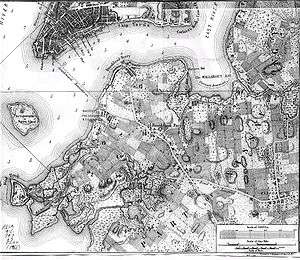

Buttermilk Channel is a small tidal strait in Upper New York Bay in New York City, approximately 1 mile (1.6 km) long and 0.25 miles (0.40 km) wide, separating Governors Island from Brooklyn. The channel is marked by a number of navigation aids (green cans no. 5 and 7 at the northeast entrance, and green gong no. 1, marking low water off the tip of Governors Island). Tidal currents on the channel are rather strong.
History
Origins of the name are uncertain but it is alleged to be a reference to the dairy farmers who used to cross this channel by boat to sell their milk in Manhattan markets. Some people believe that the channel got its name because crossing it was so rough that the farmers' milk was churned into butter by the time they reached Manhattan. According to another legend, before the channel was dredged to accommodate cargo ships,[1] cows were walked across it at low tide to graze on Governor's Island. In his newspaper articles about Brooklyn history, Walt Whitman wrote of a time "as late as the Revolutionary War (when) cattle were driven across from Brooklyn, over what is now Buttermilk Channel, to Governors Island."[2] In the bitter volcanic winter of 1817— the volcanic winter following the "Year Without a Summer"— when the thermometer dropped to −26 °F (−32 °C), the waters of the Upper Bay froze so hard that horse-drawn sleighs were driven across Buttermilk Channel to Governors Island.[3]
On the Brooklyn side, modern development started in the 1840s, when the Atlantic Basin and docks, and the "Erie Basin" were started. The former is now the Red Hook Container Port and the Brooklyn Cruiseship Terminal, while the latter is now the site of the Brooklyn IKEA.[4]
In 1902[5] the channel was dredged extensively by the U.S. Army Corps of Engineers. With current charted depths of 35 to 40 feet (11 to 12 m), Buttermilk Channel is still a busy shipping lane offering the most convenient access to the Brooklyn waterfront.
Until the late 20th century the primary user of the channel was the U.S. Coast Guard, which had a local headquarters on Governor's Island.[4]
In April 2015 the US Army Corps of Engineers issued a Request for Proposals for additional maintenance dredging of Buttermilk Channel.[6]
References
- ↑ "The passage between Governor's-Island and Long-Island, formerly called Butter-milk channel, and within the memory of man, both narrow and shallow, is now eight fathoms deep," reported The Medical Repository, February–April 1806, p 433, quoted at The Big Apple: Buttermilk Channel.
- ↑ Brooklyn Historical Society, 2000, pp. 14-15
- ↑ Burrows and Wallace, p. 494.
- 1 2 Jackson, p.173}
- ↑ Subsequent modifications were made in 1913, 1935 and 1962 ((US Army Corps of Engineers) Buttermilk Channel, NY: Federal Navigation Channel, Maintenance of Infrastructure and Stewardship, Aug/sept 2008
- ↑ "Maintenance Dredging of Buttermilk Channel, NY", fbo.gov, April 28, 2015
Bibliography
- Red Hook Gowanus Historical Guide (Brooklyn Historical Society, 2000)
- Jackson, Kenneth T., ed. (1995), The Encyclopedia of New York City, New Haven: Yale University Press, ISBN 0300055366
- Burrows, Edwin G. & Wallace, Mike (1999), Gotham: A History of New York City to 1898, New York: Oxford University Press, ISBN 0-195-11634-8
Coordinates: 40°41′06″N 74°00′54″W / 40.68500°N 74.01500°W