Butzbach
| Butzbach | ||
|---|---|---|
|
Aerial view | ||
| ||
 Butzbach | ||
Location of Butzbach within Wetteraukreis district 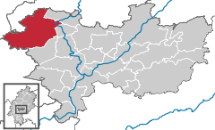
 | ||
| Coordinates: 50°26′12″N 8°39′44″E / 50.43667°N 8.66222°ECoordinates: 50°26′12″N 8°39′44″E / 50.43667°N 8.66222°E | ||
| Country | Germany | |
| State | Hesse | |
| Admin. region | Darmstadt | |
| District | Wetteraukreis | |
| Government | ||
| • Mayor | Michael Merle (SPD) | |
| Area | ||
| • Total | 106.60 km2 (41.16 sq mi) | |
| Population (2015-12-31)[1] | ||
| • Total | 25,557 | |
| • Density | 240/km2 (620/sq mi) | |
| Time zone | CET/CEST (UTC+1/+2) | |
| Postal codes | 35510 | |
| Dialling codes | 06033 | |
| Vehicle registration | FB | |
| Website | www.stadt-butzbach.de | |


Butzbach (German pronunciation: [ˈbʊtsbax]) is a town in the Wetteraukreis district in Hessen, Germany. It is located approximately 16 km south of Gießen and 35 km north of Frankfurt am Main.
In 2007, the town hosted the 47th Hessentag state festival from 1 to 10 June.
The "Landgrafenschloss" ("landgraves' castle"), used by the United States Army until 1990, is now utilized by the city council. The so-called "Roman Way Housing" of the United States Army with more than 1000 apartments was returned to the German Government in October 2007 and since has been renovated and rented out to the public. The town's market place is enclosed by timber framing. The "Schrenzer" hill (or Heidelbeerberg, 385 m) overlooks the town and the country north of Frankfurt, called Wetterau. Another much higher mountain nearby is the Hausberg which features a look-out tower.
Boroughs of Butzbach
Butzbach consists of the boroughs Bodenrod, Butzbach (urban core), Ebersgöns, Fauerbach vor der Höhe, Griedel, Hausen-Oes, Hoch-Weisel, Kirch-Göns, Maibach, Münster, Nieder-Weisel, Ostheim, Pohl-Göns and Wiesental.
Twin towns — sister cities
-
 Collecchio, Italy – since 2012
 -
 Eilenburg, Saxony, Germany – since 1990
 -
 Saint-Cyr-l'École, France – since 2008
 -
 Teplá, Czech Republic
Sons and daughters of the town
- Gabriel Biel (c. 1411-1495) late medieval theologian and longtime Propst of the Brothers of the Common Life (also Fraterherren or Kugelherren) in Butzbach
- Johann Jakob Griesbach (1745-1812) professor for the New Testament in Jena since 1775 and is regarded as one of the fathers of the New Testament text critique.
- Born in Oberkleen Friedrich Ludwig Weidig (1791-1837) worked 22 years as teacher and rector of the school in Butzbach
- Lorenz Diefenbach (1806-1883) librarian, pastor, Germanist, lexicographer and writer
- Friedrich Schwally (1863-1919) German orientalist.
- Ernst Glaeser (1902-1963) writer who used among others the pseudonyms Anton Ditschler, Erich Meschede, Alexander Ruppel
- Born in Nieder-Weisel, Peter Krick (born 1944) was a three-figure German champion in figure skating
- Dieter Enders (born 1946) is a German chemist and expert in the field of asymmetric synthesis
- Siegfried Zielinski (born 1951), media scientist and university lecturer
- Ron Gardenhire, (born 1957), former Major League Baseball manager for the Minnesota Twins
References
- ↑ "Bevölkerung der hessischen Gemeinden". Hessisches Statistisches Landesamt (in German). August 2016.
External links
| Wikimedia Commons has media related to Butzbach. |
- Official website (German)
- Town museum website (German)
- English description (English)
Towns and municipalities in Wetteraukreis district | ||
|---|---|---|