Bystrianska Cave
Bystrianska Cave is a limestone cave located on the southern slopes of the Nizke Tatry Mountains, along the road towards Banska Bystrica, at the southern edge of the town of Bystrá, in the Brezno District, Banskobystrický region, in Slovakia.
History
The old parts of the cave have been known already in the prehistoric times. Though the precipice Peklo the new parts have been discovered by E. and A. Hollmann and J. Kovalčík in 1926.[1] In 1951 the Mostárenské Hall was discovered. The lower entrance to the cave was opened in 1932. The Old and New Cave were connected by J. Majko and J. Vytřísalová together with their colleagues in 1955. About 490 m of the cave has been made public in 1968. The Lower Guerilla Hall and some other parts of the cave have been used for speleotherapy since 1971.
Description
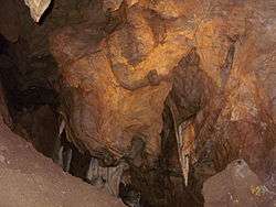
The cave consists primarily of dark limestone rocks of the middle trias, formed in tectonic cracks by water corrosion, the demolition of some parts of the ceiling and gradually enlarged by the underground river Bystra. An underground stream still flows through the bottom part of the cave, springing out in the village of Valaska. The embellishment of the cave consists of stalactites and stalagmites, wrom which Zvonivé stalaktity (Ringing statlctites), Beldachýn (Baldaquin) and Kovacska vyhna (Blacksmith's workshop) are specially remarkable. Except for many erosive forms a ceilng river-bed is to be seen in the cave, in which the round granit stones of the Low Tatras are attached by sinter. The cave is 2637 m in length and 95 m in depth. It is the most important cave of the Upper Hron River Valley. [2]
In the largest dome there is a memorial tablet commemorating the partisan who was shot dead by fascist soldiers directly in the cave. Aside the sightseeing tour there is a medical hall used presenyly for curing the respiratory diseases of children (speleotherapy).
See also
References
- ↑ "Bystrianska Cave - The National Nature Monument". Archived from the original on 2010-10-10. Retrieved 2010-02-24.
- ↑ "The Bystrianska Jaskyna Cave (brochure)".
External links
| Wikimedia Commons has media related to Bystrianska Cave. |
- Bystrianska Cave at Slovak Caves Administration.
Coordinates: 48°50′25″N 19°35′46″E / 48.84028°N 19.59611°E