Cabras Island
For the island in São Tomé and Príncipe, see Ilhéu das Cabras.
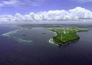
Cabras Island is the low-lying land to the left in this view of Apra Harbor's mouth
Cabras Island is a long finger of low-lying reef and land which forms the northern shore of Apra Harbor, Guam.
The island's length has been extended artificially by the Glass Breakwater, named for Captain Henry Glass, who captured Guam for the United States in 1898 during the Spanish–American War. A road extends to the breakwater, though this is sometimes closed for security reasons during visits by ships.
The opposite coast of the harbor is formed by the Orote Peninsula, which houses Naval Base Guam and Point Udall (formerly Orote Point), mainland Guam's westernmost extremity.
References
- Bendure, G. & Friary, N. (1988) Micronesia: A Travel Survival Kit. South Yarra, VIC: Lonely Planet.
Coordinates: 13°27′43″N 144°40′27″E / 13.4620°N 144.6742°E
This article is issued from Wikipedia - version of the 12/14/2015. The text is available under the Creative Commons Attribution/Share Alike but additional terms may apply for the media files.