Cadier en Keer
| Cadier en Keer | |
|---|---|
| Village | |
| Coordinates: 50°49′38″N 5°46′10″E / 50.82722°N 5.76944°E | |
| Country | Netherlands |
| Province | Limburg (Netherlands) |
| Municipality | Eijsden-Margraten |
| Population (2010) | 3.633 |
| Major roads | N278 |
Coordinates: 50°50′N 5°46′E / 50.833°N 5.767°E
Cadier en Keer (Limburgish: Keer) is a town in the Dutch province of Limburg. It is a part of the municipality of Eijsden-Margraten, and lies about 5 km east of Maastricht.
Cadier was a separate municipality until 1828. Cadier en Keer was a separate municipality between 1828 and 1982, when it was merged with Margraten.[1]
In 2010, Cadier en Keer had 3.633 inhabitants. Cadier en Keer used to be two separate villages, Cadier and Keer. The built-up area of the town was 0.76 km², and contained 1332 residences.[2]
Gallery
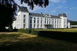
 Kasteel Blankenberg at Cadier en Keer |
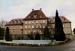
 Gerlach building at Cadier en Keer |
References
- ↑ Ad van der Meer and Onno Boonstra, Repertorium van Nederlandse gemeenten, KNAW, 2006.
- ↑ Statistics Netherlands (CBS), Bevolkingskernen in Nederland 2001 "Archived copy". Archived from the original on 2006-03-19. Retrieved 2007-01-24.. Statistics are for the continuous built-up area.
External links
| Wikimedia Commons has media related to Cadier en Keer. |
- J. Kuyper, Gemeente Atlas van Nederland, 1865-1870, "Cadier en Keer". Map of the former municipality, around 1868.
This article is issued from Wikipedia - version of the 11/12/2016. The text is available under the Creative Commons Attribution/Share Alike but additional terms may apply for the media files.