Calceta
| Calceta | |||
|---|---|---|---|
| |||
| Motto: Calceta, ls sin par (Calceta, the peerless) | |||
 Calceta | |||
| Coordinates: 0°50′24″S 80°10′12″W / 0.84000°S 80.17000°WCoordinates: 0°50′24″S 80°10′12″W / 0.84000°S 80.17000°W | |||
| Country | Ecuador | ||
| Province | Manabí | ||
| Demonym | Calcetense-Bolivacense | ||
| City Established | October 13, 1913 | ||
| Government | |||
| • Mayor | Ramon Gonzalez Alava | ||
| Area | |||
| • Total | 650 km2 (250 sq mi) | ||
| Population (2008) | |||
| • Total | 17,682 | ||
| Time zone | -5GMT | ||
| Area code(s) | +593 5 | ||
| Climate | Aw | ||

Calceta is a town in the Manabí province of Ecuador. Situated on the banks of the Carrizal river, and surrounded a valley of the same name, Calceta is a center of trade and services for the north-central zone of Manabí. It has a dozen high schools and more than twenty schools. 3 kilometres away is the Escuela Superior Politécnica de Manabí (ESPAM), a modern agricultural and environmental university.
Attractions
The tower of the Juan Manuel Alava public clock, The Saint Agustín Church, the Civic Square, and the San Bartolo old red bridge, assembled in 1910.
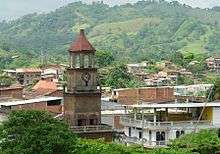
Calceta Clock Tower (Reloj del Publico Calceta)
Sources
- World-Gazetteer.com
This article is issued from Wikipedia - version of the 6/3/2016. The text is available under the Creative Commons Attribution/Share Alike but additional terms may apply for the media files.