California State Route 108
| ||||
|---|---|---|---|---|
|
Map of east central California with SR 108 highlighted in red | ||||
| Route information | ||||
| Defined by Streets and Highways Code § 408 | ||||
| Maintained by Caltrans | ||||
| Length: | 120 mi[1] (193 km) | |||
| Restrictions: | Segment through Sonora Pass closed in winter | |||
| Major junctions | ||||
| West end: |
| |||
| East end: |
| |||
| Highway system | ||||
| ||||

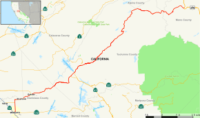
State Route 108, also known as Highway 108, is a numbered state highway in California. SR 108 runs generally northeast across central California from downtown Modesto near the SR 99/SR 132 interchange, crossing the Sierra Nevada at Sonora Pass, to U.S. Route 395 near the Nevada state line. The route was once recommended to continue south of Modesto to Interstate 5, although today the route is a county road. Parts of SR 108 are closed annually during the winter due to inclement weather along the summit.
Route description
This route is part of the California Freeway and Expressway System[2] and is eligible for the State Scenic Highway System.[3] However, it is not a scenic highway as defined by Caltrans.[4]
State Route 108 begins in downtown Modesto at the junction of SR 99 and SR 132, overlapping SR 132 for several blocks northeast on L Street to 9th Street. There it splits into a short one-way pair, with eastbound SR 108 turning southeast with SR 132 on 9th Street to K Street and then northeast to Needham Street; the westbound direction remains on L Street to Needham Street. After several blocks eastward on Needham Street, SR 108 reaches McHenry Avenue, which it follows north out of the city. There is no route marker eastbound indicating where the route turns left from 9th Street to K Street, nor is there a route marker indicating where the westbound traffic turns left from Needham Street to L Street.
From Modesto, SR 108 runs north along McHenry Avenue for about 7 miles (11 km) before turning eastward on Patterson Road to follow the Stanislaus River east-northeast. In Riverbank, County Route J7 comes from the north and departs to the south after about a one-mile (1.6 km) co-routing. After following the river about 10 miles (16 km), SR 108 passes straight through the heart of downtown Oakdale.
At the main intersection in Oakdale, SR 120 joins SR 108 from the north and they are co-signed as they continue northeast, climbing into the foothills and passing just south of Knights Ferry. SR 120 brings with it the title Northern Yosemite Highway for this segment; with State Route 132 being the middle route from the west and State Route 140 being the southern route to Yosemite. Just past Knights Ferry, SR 108 crosses from Stanislaus County into Tuolumne County, and the road changes from two lanes to four-lane separated highway for about 6 miles (9.7 km). This is advantageous as steep grade is located along this stretch of the road and the extra lanes are useful as passing lanes both ascending and descending the mountain range. About a mile after the end of the separated pavement, La Grange Road (County road J59) heads south, passing just west of Lake Don Pedro and meeting SR 132 near the town of La Grange. Another 3 miles (4.8 km) eastward, at Yosemite Junction, SR 120 finally separates from SR 108 and heads southward toward to a co-routing with State Route 49 through Chinese Camp and across the upper end of Lake Don Pedro.

Another 3 miles (4.8 km) eastward, SR 49 joins from the south and is co-routed with SR 108 through Jamestown and into Sonora, where SR 49 departs to the north. SR 108 continues eastward and gains elevation as it passes through Twain Harte, Mi-Wuk Village, Long Barn, Cold Springs, Strawberry-Pinecrest Lake and Dodge Ridge Ski Area, then on to Dardanelle and Kennedy Meadow. SR 108 crosses the summit of the Sierra Nevada mountains at Sonora Pass, then descends past the Mountain Warfare Training Center at Pickel Meadows, finally reaching the eastern terminus at Sonora Junction where it meets U.S. Route 395.
Major intersections
Except where prefixed with a letter, postmiles were measured on the road as it was in 1964, based on the alignment that existed at the time, and do not necessarily reflect current mileage. R reflects a realignment in the route since then, M indicates a second realignment, L refers an overlap due to a correction or change, and T indicates postmiles classified as temporary (for a full list of prefixes, see the list of postmile definitions).[5] Segments that remain unconstructed or have been relinquished to local control may be omitted. The numbers reset at county lines; the start and end postmiles in each county are given in the county column.
| County | Location | Postmile [5][6][7] | Destinations | Notes | |
|---|---|---|---|---|---|
| Stanislaus STA 14.73[N 1]-T18.17[N 2] | Modesto | 14.73[N 1] | Continuation beyond SR 99 | ||
| 14.73[N 1] | Interchange; west end of SR 132 overlap; west end of SR 108 | ||||
| 15.06[N 1] R22.44 | East end of SR 132 overlap; serves Modesto City-County Airport | ||||
| 24.81 | Briggsmore Avenue | ||||
| 26.06 | Standiford Avenue, Sylvan Avenue | ||||
| | 27.62 | ||||
| | 29.15 | ||||
| Riverbank | 31.05 | Oakdale Road | |||
| 32.44 | West end of CR J7 overlap | ||||
| | 33.38 | East end of CR J7 overlap | |||
| Oakdale | 38.24 5.12[N 2] | West end of SR 120 overlap | |||
| Tuolumne TUO R0.00[N 2]-66.97 | | 8.19[N 2] | |||
| | | ||||
| | 12.08[N 2] L0.00 | East end of SR 120 overlap | |||
| | L2.81 R11.59[N 3] | West end of SR 49 overlap | |||
| Jamestown | 14.74[N 3] | ||||
| Sonora | 16.48[N 3] R0.00 | Interchange; east end of SR 49 overlap; former SR 108 east; west end of Sonora bypass | |||
| | R2.20 | Interchange; former SR 108 | |||
| | R3.42 | Hess Avenue, Phoenix Lake Road | Interchange | ||
| | R4.50 | Peaceful Oak Road, Standard Road | Interchange; eastbound exit and westbound entrance | ||
| | R5.50 | Former SR 108 west; east end of Sonora bypass | |||
| | 7.51 | Soulsbyville Road – Mono Vista, Soulsbyville, Willow Springs, Tuolumne City | |||
| | R9.58 | Twain Harte Drive (SR 108 Bus. east), Plainview Road – Twain Harte | |||
| Twain Harte | R11.75 | ||||
| Mono | | 15.15 | East end of SR 108 | ||
1.000 mi = 1.609 km; 1.000 km = 0.621 mi
| |||||
References
- ↑ January 1, 2006 California Log of Bridges on State Highways
- ↑ CA Codes (shc:250-257)
- ↑ CA Codes (shc:260-284)
- ↑ "Officially Designated State Scenic Highways and Historic Parkways". California Department of Transportation. December 7, 2007. Retrieved June 23, 2011.
- 1 2 California Department of Transportation. "State Truck Route List". Sacramento: California Department of Transportation. Archived from the original (XLS file) on June 30, 2015. Retrieved June 30, 2015.
- ↑ California Department of Transportation, Log of Bridges on State Highways, July 2007
- ↑ California Department of Transportation, All Traffic Volumes on CSHS, 2005 and 2006