California State Route 271
| ||||
|---|---|---|---|---|
|
Map of northwestern California with SR 271 highlighted in red | ||||
| Route information | ||||
| Defined by Streets and Highways Code § 571 | ||||
| Maintained by Caltrans | ||||
| Length: | 14.84 mi[1] (23.88 km) | |||
| Section 1 | ||||
| South end: |
| |||
| North end: |
| |||
| Section 2 | ||||
| South end: |
| |||
| North end: |
| |||
| Highway system | ||||
| ||||

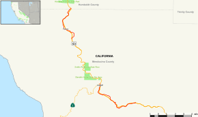
State Route 271 (SR 271) is a state highway in northern California, USA. It is a former routing of U.S. Route 101 (US 101), now reduced to being a frontage road for that route in discontiguous segments. It also connects with Route 1 just before that route's terminus with US 101 in Leggett. Its appeal now is that while US Highway 101 stays mostly in second growth redwoods, State Route 271 travels through several old growth redwood groves. It is now most commonly used as a scenic alternate.
Route description
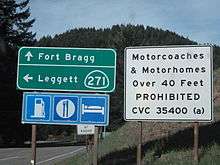
The southern portion of SR 271 begins at an interchange with US 101 in the community of Cummings. SR 271 winds through the forest, paralleling US 101 and intersecting it twice on its northwest journey. The highway eventually comes into the southern area of Leggett, where SR 271 comes to another grade-separated interchange with US 101. The road continues north, paralleling US 101 to the west, and passing through the Drive-Thru Tree Park. The southern segment of SR 271 terminates at SR 1 in Leggett.[2]
The northern portion of SR 271 begins at another interchange with US 101 and parallels US 101 to the east. At an interchange, it passes to the west of US 101 and continues north to the community of Cooks Valley, where it terminates at an interchange with US 101.[3]
History
CA 271 was part of U.S. Route 101 until a freeway bypass completed in 1970–1974, assuming the 101 designation. The former highway was then designated as CA 271.
Major intersections
Except where prefixed with a letter, postmiles were measured on the road as it was in 1964, based on the alignment that existed at the time, and do not necessarily reflect current mileage. R reflects a realignment in the route since then, M indicates a second realignment, L refers an overlap due to a correction or change, and T indicates postmiles classified as temporary (for a full list of prefixes, see the list of postmile definitions).[4] Segments that remain unconstructed or have been relinquished to local control may be omitted. The numbers reset at county lines; the start and end postmiles in each county are given in the county column.
| County | Location | Postmile [4][5][6] | Destinations | Notes | |||
|---|---|---|---|---|---|---|---|
| Mendocino MEN 0.00-22.72 | | 0.00 | Interchange; south end of SR 271 | ||||
| South Leggett | 5.60 | Interchange | |||||
| Leggett | 7.31 | Former SR 208 | |||||
| Gap in route | |||||||
| Reynolds | R17.05 | Interchange | |||||
| Piercy | 19.46 | Interchange | |||||
| Humboldt HUM 0.00-0.30 | Cooks Valley | 0.30 | North end of SR 271 | ||||
| 1.000 mi = 1.609 km; 1.000 km = 0.621 mi | |||||||
References
- ↑ January 1, 2006 California Log of Bridges on State Highways
- ↑ Google (2011-03-19). "California State Route 271 - southern portion" (Map). Google Maps. Google. Retrieved 2011-03-19.
- ↑ Google (2011-03-19). "California State Route 271 - northern portion" (Map). Google Maps. Google. Retrieved 2011-03-19.
- 1 2 California Department of Transportation. "State Truck Route List". Sacramento: California Department of Transportation. Archived from the original (XLS file) on June 30, 2015. Retrieved June 30, 2015.
- ↑ California Department of Transportation, Log of Bridges on State Highways, April 2008
- ↑ California Department of Transportation, All Traffic Volumes on CSHS, 2007