Canal Dunkerque-Escaut
| Canal Dunkerque-Escaut | |
|---|---|
|
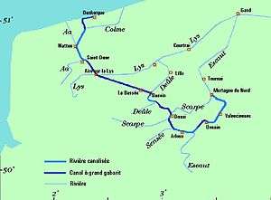
Map of Dunkerq Escaut Waterway | |
| Specifications | |
| Length | 187 km (116 mi) Dunkirk to Belgium via Valenciennes [1] |
| Maximum boat length | 143 m (469 ft) |
| Maximum boat beam | 11 m (36 ft) |
| Locks | 14 [1] |
The Canal Dunkerque-Escaut is a 189 km series of large canals from Dunkerque to Mortagne-du-Nord. The route is also known as the liaison, La Liaison au Grand Gabarit, Canal au Grand Gabarit, Dunkerque-Escaut Waterway and Liaison Dunkerque-Escaut.
The Grand Gabarit (English: Large Gauge) canal route was created after the Second World War to accommodate very large commercial vessels - up to 143m long by 11m wide. This includes push-tows and side-by-side configurations. Existing canals were straightened and widened; and locks (ecluses) were enlarged.
The route
Different references have it as different lengths depending on beginning and ending points. All agree on the beginning as Dunkerque:
- Ending in Doornik Belgium is 202 km (126 mi) with 14 locks[2]
- Ending at Belgium border is 187 km (116 mi) with 14 locks [1]
- Ending at Mortagne-du-Nord 189 km (117 mi) with 14 locks [3]
The route includes, starting in Dunkerque:[1] [3]
- Canal de Bourbourg from Dunkerque to 50°53′19″N 2°14′49″E / 50.88869°N 2.24696°E between Lynck and Pont l'Abbesse
- Canal de la Colme from 50°53′19″N 2°14′49″E / 50.88869°N 2.24696°E to Watten
- River Aa from Watten to Arques
- Canal de Neufossé from Arques to Aire-sur-la-Lys
- Canal d'Aire from Aire-sur-la-Lys to Bauvin
- Canal de la Deûle from Bauvin to Douai
- Canal de la Sensée from Douai to Bassin Rond
- River Scheldt from Bassin Rond via Valenciennes to Belgium
See also
References
- 1 2 3 4 McKnight, Hugh (2005). Cruising French Waterways, 4th Edition. Sheridan House. ISBN 978-1-57409-087-1.
- ↑ Jefferson, David (2009). Through the French Canals. Adlard Coles Nautical. p. 275. ISBN 978-1-4081-0381-4.
- 1 2 Vois Navigables France Itinéraires Fluviaux. Editions De L'Ecluse. 2009. ISBN 978-2-916919-21-8.
External links
- Grand Gabarit guide Places, ports and moorings on the canal(s).
- Map
This article is issued from Wikipedia - version of the 11/13/2016. The text is available under the Creative Commons Attribution/Share Alike but additional terms may apply for the media files.