Canal de l'Est

Canal de l'Est in the waterway network in eastern France.

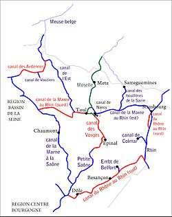
The Canal de l'Est (French: "canal of the east") is a canal in northeastern France. It was built from 1874 to 1887 and has a total length of 394 kilometres (245 mi). It consists of two parts: a northern branch linking the Meuse River and the Moselle, and a southern branch linking the Moselle to the Saône. In 2003, these branches were officially renamed Canal de la Meuse and Canal des Vosges, respectively.

Northern branch (Canal de la Meuse)

Canal de la Meuse at Mouzon

The northern branch of the Canal de l'Est starts at Givet in the Ardennes department. It follows the Meuse upstream, passing through Mouzon, Fumay, Revin, Nouzonville, Charleville-Mézières, Sedan, Stenay, Verdun, Saint-Mihiel and Commercy until it joins the Canal de la Marne au Rhin at Troussey. This branch of the canal is 272 kilometres (169 mi) long. For much of its length, the canal is actually the canalised river Meuse.

Southern branch (Canal des Vosges)

Canal des Vosges at Golbey

Originally, the southern branch of the Canal de l'Est started at Toul, where it branched off the Canal de la Marne au Rhin. Since the Moselle has been made navigable for larger ships up to Neuves-Maisons, the 27-kilometre (17 mi) part of the Canal de l'Est between Toul and Neuves-Maisons is considered part of the Moselle. The canal follows the Moselle upstream through Charmes and Thaon-les-Vosges until Golbey, north of Épinal, where it leaves the Moselle valley. It passes through Les Forges and enters the valley of the Côney near Uzemain. It follows the Côney downstream until its confluence with the Saône at Corre in the Haute-Saône department, the southern end of the Canal de l'Est. This branch of the canal is 123 kilometres (76 mi) long.

Geographic latitude and longitude

branch commune latitude and longitude
northern Givet 50°09′55″N 4°49′23″E / 50.165339°N 4.823090°E / 50.165339; 4.823090 (Givet)
northern Fumay 49°59′42″N 4°42′17″E / 49.995027°N 4.704711°E / 49.995027; 4.704711 (Fumay)
northern Revin 49°56′26″N 4°38′19″E / 49.940532°N 4.638501°E / 49.940532; 4.638501 (Revin)
northern Nouzonville 49°49′00″N 4°44′28″E / 49.816795°N 4.741077°E / 49.816795; 4.741077 (Nouzonville)
northern Charleville-Mézières 49°45′35″N 4°43′28″E / 49.759734°N 4.724509°E / 49.759734; 4.724509 (Charleville-Mézières)
northern Sedan 49°42′06″N 4°56′09″E / 49.701676°N 4.935798°E / 49.701676; 4.935798 (Sedan)
northern Mouzon 49°36′34″N 5°04′20″E / 49.609429°N 5.072111°E / 49.609429; 5.072111 (Mouzon)
northern Stenay 49°29′22″N 5°10′56″E / 49.489465°N 5.182199°E / 49.489465; 5.182199 (Stenay)
northern Verdun 49°09′11″N 5°23′01″E / 49.153179°N 5.383668°E / 49.153179; 5.383668 (Verdun)
northern Saint-Mihiel 48°53′19″N 5°32′11″E / 48.888597°N 5.536481°E / 48.888597; 5.536481 (Saint-Mihiel)
northern Commercy 48°45′57″N 5°35′42″E / 48.765725°N 5.595111°E / 48.765725; 5.595111 (Commercy)
northern Troussey 48°42′52″N 5°41′24″E / 48.714535°N 5.690091°E / 48.714535; 5.690091 (Troussey)
southern Toul 48°40′59″N 5°54′23″E / 48.683183°N 5.906358°E / 48.683183; 5.906358 (Toul)
southern Neuves-Maisons 48°36′25″N 6°06′30″E / 48.606976°N 6.108320°E / 48.606976; 6.108320 (Neuves-Maisons)
southern Charmes 48°22′27″N 6°17′43″E / 48.374052°N 6.295253°E / 48.374052; 6.295253 (Charmes)
southern Thaon-les-Vosges 48°14′50″N 6°25′32″E / 48.247316°N 6.425521°E / 48.247316; 6.425521 (Thaon-les-Vosges)
southern Golbey 48°12′33″N 6°26′23″E / 48.209058°N 6.439801°E / 48.209058; 6.439801 (Golbey)
southern Les Forges 48°10′54″N 6°23′24″E / 48.181601°N 6.390107°E / 48.181601; 6.390107 (Les Forges)
southern Uzemain 48°06′25″N 6°18′57″E / 48.106896°N 6.315748°E / 48.106896; 6.315748 (Uzemain)
southern Corre 47°54′41″N 5°59′41″E / 47.911417°N 5.994600°E / 47.911417; 5.994600 (Corre)

See also

References

This article is issued from Wikipedia - version of the 10/2/2016. The text is available under the Creative Commons Attribution/Share Alike but additional terms may apply for the media files.