Canal du Centre (France)
| Canal du Centre | |
|---|---|
|
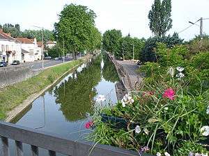
Canal du Centre in Paray-le-Monial. | |
| Specifications | |
| Length | 112.1 km (69.7 mi) [1] |
| Locks | 61 [2] (originally 80) |
| Status | Open |
| History | |
| Former names | Canal du Charollais |
| Principal engineer | Émiland Gauthey |
| Date approved | 1783 |
| Construction began | 1784 |
| Date of first use | 1792 |
| Date completed | 1792 |
| Geography | |
| Start point | Digoin |
| End point | Chalon-sur-Saône |
| Beginning coordinates | 46°28′39″N 3°58′50″E / 46.47756°N 3.98053°E at aqueduct crossing Loire in Digoin |
| Ending coordinates | 46°47′53″N 4°52′48″E / 46.79812°N 4.88008°E |
| Branch of | Bourbonnais route |
| Connects to | Canal latéral à la Loire in Digoin, Saône in Chalon-sur-Saône |
The Canal du Centre, originally known as the Canal du Charollais, is a French canal running from Digoin, where it now joins the Canal latéral à la Loire, to the River Saône in Chalon-sur-Saône. It was opened in 1792 and made it possible for the first time for boat traffic to pass from the north of France to the south. It is 112.1 km long and has 61 locks. Most of its traffic came from the coal mines at Montceau-les-Mines.
.png)
History
The canal was first suggested during the 16th century, under King Francis I and a detailed plan was prepared by Adam de Craponne in the time of Henry II. But nothing more happened until the Chief Engineer of Burgundy, Émiland Gauthey, obtained building powers in 1783. He selected a route which joined the valleys of the Loire and Saône and provided adequate water supplies at the summit. The first stone was laid in 1784 by Prince de Condé and despite the intervention of exceptional floods on the Loire in 1790, which totally wrecked a new port in Digoin, and the Revolution, the works were completed in 1792.
The canal brought new life to the Charollais and within 20 years of opening, many villages had sprung up along its banks. But the amount of traffic that could be carried towards Paris was limited by the fickle nature of the Loire, and it was estimated that the opening of the Canal Latéral à la Loire would triple the toll income of the canal. This happened in 1838, five years after the establishment of coal mines at Montceau-les-Mines, and this increased the traffic until in 1936 some 1,622,000 tonnes of coal was carried on the canal. But the coal traffic sharply declined during the 1980s, and the mines were closed in 2000.
Layout
Originally 80 locks took the canal up by 77.64 m from the Loire and down 130.9 m to the Saône. These were enlarged in 1880-1900 when they were all rebuilt whilst bringing them up to the Freycinet gauge and the number of locks reduced. During the 1950s about 5 km of canal in the centre of Chalon was replaced by a new cut upstream of the town with a single 10.76 m deep lock replacing 3 locks.
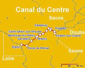
Route
- PK 112 Digoin
- PK 102 Paray-le-Monial
- PK 81 Génelard
- PK 65 Montceau-les-Mines
- PK 61 Blanzy
- PK 52 Montchanin
- PK 45 Saint-Julien-sur-Dheune
- PK 33 Saint-Léger-sur-Dheune
- PK 24.5 Santenay
- PK 19 Chagny
- PK 17 Rully
- PK 8 Fragnes
- PK 0 Chalon-sur-Saône
See also
References
External links
| Wikimedia Commons has media related to Canal du Centre (France). |