Canal latéral à l'Oise
| Canal latéral à l'Oise | |
|---|---|
|
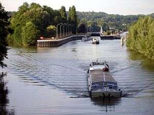
Lock on the Oise at L'Isle-Adam, Val-d'Oise, France | |
| Specifications | |
| Length | 138 km (86 mi) |
| Lock length | 39 m (128 ft) |
| Lock width | 6.5 m (21 ft) |
| Locks | 11 (4 in the canal and 7 in the Oise) |
| Total rise | 10.45 km (6.49 mi) in the Oise, 13.1 km (8.1 mi) in the canal.[1] |
| Status | Open |
| Geography | |
| Start point | Canal de Saint-Quentin at Chauny |
| End point | Seine at Conflans-Sainte-Honorine |
| Beginning coordinates | 49°36′32″N 3°13′43″E / 49.60883°N 3.22861°E [1] |
| Ending coordinates | 48°59′18″N 2°04′18″E / 48.98830°N 2.07157°E [1] |
| Connects to | Canal de Saint-Quentin, Seine, Canal du Nord |
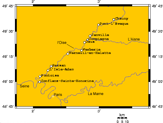
The Canal latéral à l'Oise is a canal in northern France that, along with the River Oise, connects the Canal de Saint-Quentin at Chauny to the Seine at Conflans-Sainte-Honorine.[1]
The path is made up of the canal and the canalized River Oise. When a canal has the word latéral as part of its name, the canal follows the path of the river it is named after but is in a separate bed. When a river is canalized, locks have been placed in the bed of the river so that the river acts as a canal. So, the path described in this article is 34 km of a canal parallel to the River Oise and 103.5 km of the River Oise converted to a canal. The transition point is in Janville. 49°27′45″N 2°51′54″E / 49.46255°N 2.86503°E
En route
The PK numbers below go from 0 to 34 at Janville and then decrease from 103.5 to 0 at the Seine.
- PK 0 Chauny from Canal de Saint-Quentin
- PK 3 Left to Canal de l'Oise à l'Aisne at Abbécourt
- PK 18 Pont l'Eveque
- PK 18.5 Left to Canal du Nord
- PK 33 Longueil-Annel
- PK 34 Lock #4, double, at Janville
- PK 103.5 Janville continues as l'Oise
- PK 99 Left to River Aisne
- PK 98 Compiègne
- PK 91.5 Jaux
- PK 99 Connects to River Aisne
- PK 82 Verberie
- PK 70.5 Pont-Sainte-Maxence
- PK 62 Verneuil-en-Halatte
- PK 59 Nogent-sur-Oise and Creil
- PK 34 Persan and Beaumont-sur-Oise
- PK 27 L'Isle-Adam
- PK 15 Pontoise
- PK 9 Cergy Suburb NW of Paris
- PK 0 T-Junction with Seine and Conflans-Sainte-Honorine, the Barge Capital of France.