Canton Island Airport
| Kanton Island Airport | |||||||||||
|---|---|---|---|---|---|---|---|---|---|---|---|
| IATA: CIS – ICAO: PCIS | |||||||||||
| Summary | |||||||||||
| Location | Kiribati | ||||||||||
| Elevation AMSL | 9 ft / 3 m | ||||||||||
| Coordinates | 02°46′09″S 171°42′19″W / 2.76917°S 171.70528°WCoordinates: 02°46′09″S 171°42′19″W / 2.76917°S 171.70528°W | ||||||||||
| Runways | |||||||||||
| |||||||||||
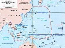
Canton Island Airport (IATA: CIS, ICAO: PCIS) is an emergency use airport located on the sparsely populated Kanton Island, in the Phoenix Islands, in the Republic of Kiribati. It has a single runway 6,230 feet (1,900 m) in length, paved with asphalt. Though it was once a major stop on commercial trans-Pacific airline routes, it is for the most part abandoned today.
Construction
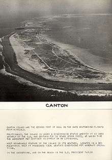
During World War II, Kanton (then spelled "Canton") Island was considered part of the British-controlled Gilbert and Ellice Islands colony. The atoll is a low, narrow rim of land surrounding a large shallow lagoon. It is 4½ miles wide on the west, from which it narrows to the southeast point, which is nine miles distant from the northwest point. The airfield was built on the island's northwestern corner by Pan American Airways between 1938–39, and was used by that airline as a stopover on its route from Hawaii to New Zealand. Pan American also cleared and deepened a portion of the lagoon during this time.
The Pan American pioneered central air route, Hawaii to the Philippines and Asia by way of stations at Midway, Wake and Guam passed through the Japanese controlled islands with serious concerns about its safety growing in 1941 even as the Army had reinforced the Philippines with a flight of B-17 bombers by way of Midway, Wake and Port Moresby in September. The War Department approved a plan with orders effective 4 October 1941 to build an alternate air ferry route skirting the mandated islands and capable of handling planes such as the B-17s. While a commercial firm was engaged for most of the island stops of the new route, the Kanton field was under construction by a team of Army Engineers and civilian contractors with a target opening of bomber capability by January 1942.[1][2] The effort began on 3 November with a transport carrying 130 troops and civilian contractors and towing four barges of equipment departed Honolulu arriving at the island 14 November after losing two of the barges.[3] By 28 December, despite considerable difficulties, the field was declared suitable to accommodate heavy bombers.[4] On 31 January 1942 garrison forces for the island, then codenamed "HOLLY," sailed from San Francisco.[5]
The political status of the island was uncertain at first, with American and British settlers occupying two separate camps on the island. On March 3, 1938 President Franklin Roosevelt placed Canton and Enderbury Island under jurisdiction of the United States Department of the Interior, but this claim was strenuously resisted by the British government. In April 1939, Canton and Enderbury were placed under joint British and American control for fifty years, and "thereafter until such time as it may be modified or terminated by mutual consent".
World War II
The airport was used as a military airfield during World War II by the United States Army Air Forces in 1942 and 1943, initially being used by the 40th Ferrying (later Transport) Squadron, Ferrying (later Air Transport) Command as an airfield for moving combat aircraft to forward combat units. The airfield saw various aircraft, including A-20s, B-17s, B-24s, B-25s, B-26s, P-38s, P-40s, C-46s, and C-47s transit the base. In February 1943, the long-range B-24 Liberator Bombers of the 392d Bombardment Squadron were sent to the airfield.
Though Kanton Island was never physically invaded by Japanese forces, the airfield was bombarded on 1 November 1943 by the Japanese submarine I-36. After the war, it was returned to civilian control.
After the war
Kanton Island airport continued to see use during the 1950s as a trans-Pacific stopover for DC-4, DC-6B and DC-7C aircraft for Pan American, British Commonwealth Pacific Airlines, QANTAS and Canadian Pacific Airlines, but with the advent of long-range jet aircraft during the 1960s, their need for the island faded, and the airfield and its associated facilities were ultimately abandoned in 1965. It would see occasional use thereafter in conjunction with subsequent U.S. government projects on the island (largely related to the Manned spaceflight program, in particular Project Mercury), but with the abandonment of these endeavors, the airport was finally closed for good in 1975, though it remains available as an emergency landing field.
See also
References
- ↑ Leighton 1995, p. 124.
- ↑ Dod 1987, p. 45.
- ↑ Dod 1987, p. 47.
- ↑ Dod 1987, p. 164.
- ↑ Matloff 1999, p. 151.
![]() This article incorporates public domain material from the Air Force Historical Research Agency website http://www.afhra.af.mil/.
This article incorporates public domain material from the Air Force Historical Research Agency website http://www.afhra.af.mil/.
- Dod, Karl C. (1987). The Corps Of Engineers: The War Against Japan. United States Army In World War II. Washington, DC: Center Of Military History, United States Army. LCCN 66-60004.
- Leighton, Richard M; Coakley, Robert W (1995). The War Department — Global Logistics And Strategy 1940–1943. United States Army In World War II. Washington, DC: Center Of Military History, United States Army. LCCN 55-60001.
- Matloff, Maurice; Snell, Edwin M. (1999). The War Department: Strategic Planning For Coalition Warfare 1941-1942. United States Army In World War II. Washington, DC: Center Of Military History, United States Army. LCCN 53061477.
- Maurer, Maurer, ed. (1982) [1969]. Combat Squadrons of the Air Force, World War II (PDF) (reprint ed.). Washington, DC: Office of Air Force History. ISBN 0-405-12194-6.
- Canton Island Airfield at Pacific Wrecks
External links
Previously: Hawaiian Air Force (1940-1942) | |||||||||||||||||||||||||||||||||||
| Airfields |
| .svg.png) | |||||||||||||||||||||||||||||||||
| Units |
| ||||||||||||||||||||||||||||||||||